Lodge, John, 1756 or 7-1830, engraver Roberts, Henry, Lieut
Published / Created:
1785
Call Number:
1977 Folio 177
Image Count:
2
Resource Type:
Maps, Atlases & Globes
Alternative Title:
Political magazine.
Description:
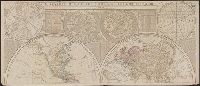
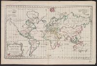
At foot of title: Political Mag. Jany. 1785., From: The political magazine and Parliamentary, naval, military, and literary journal. London : Printed for J. Bew, 1784., Imperfect: left sheet wanting. Right sheet measures 64.2 x 48.0 cm. Ms. note at head of title: Cook's voyages. Ms. note on verso: Map of Cook's last voyage. No. 12 of 34 maps bound together., Prime meridian: Greenwich., and World map showing the Endeavour's track in the years 1768-1771, Resolution's first voyage in 1772-1775 and Resolution's second voyage in 1776-1780.
Publisher:
Printed for J. Bew],
Subject (Topic):
Voyages around the world--Maps--Early works to 1800 and World maps--Early works to 1800
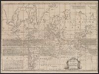
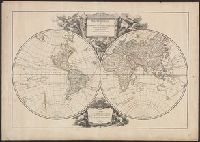
Cross collection no. 34., Double hemispherical map of the world showing countries, Dampier's voyage, winds, planetary systems, charts and appearance of the sun and moon. Relief shown pictorially., Imperfect: third name in imprint illegible. Hand col. Mounted on linen., Scale measured at center of hemisphere., and Shows California as an island.
Publisher:
Printed for I. Bowles ... Ca. Bowles ... and sold by [?] ... R. Sayer ... and Iohn King ...,
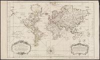
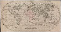
Cross collection no. 43. and Map of the world showing wind patterns and incomplete outline of Australia and New Zealand. Also shows time differences and some relief in hill shading.
At bottom of the title cartouche: "Par le S.r Bellin, Ingenieur de la Marine and New Guinea shown joined to New Holland; Dampier's Strait marked. Bellin traces the 'hypothetical' coast of New Holland which was object of speculation before Cook's discoveries.
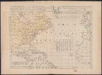
"Longitude w. from London.", "Plate III. The dominions ceded by France & Spain to Great Britain are colored with a feint red.", Accompanied by 2 leaves intended to be hinged to the margin as overlays to North America: Plate I. Clai, and Relief shown pictorially.
Subject (Geographic):
Atlantic Ocean--Maps--Early works to 1800 and North America--Maps--Early works to 1800
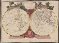
"Gravé par E. Dussy.", Cross collection no. 44., Map of the world, showing imaginary coastline of Australia joining Van Diemen's Land to d'Esprit., and Title in decorative frame; colour-coded according to major world religions.
Publisher:
Chez l'Auteur, Quai de l'Horloge pres le Pont neuf,
Subject (Name):
Dussy, E., fl. 1754-1778
Subject (Topic):
Religions--Maps--Early works to 1800 and World maps--Early works to 1800