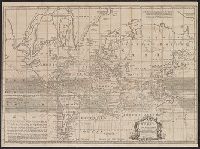
Cross collection no. 43. and Map of the world showing wind patterns and incomplete outline of Australia and New Zealand. Also shows time differences and some relief in hill shading.
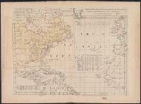
"Longitude w. from London.", "Plate III. The dominions ceded by France & Spain to Great Britain are colored with a feint red.", Accompanied by 2 leaves intended to be hinged to the margin as overlays to North America: Plate I. Clai, and Relief shown pictorially.
Subject (Geographic):
Atlantic Ocean--Maps--Early works to 1800 and North America--Maps--Early works to 1800
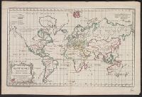
"Gravé par E. Dussy.", Cross collection no. 44., Map of the world, showing imaginary coastline of Australia joining Van Diemen's Land to d'Esprit., and Title in decorative frame; colour-coded according to major world religions.
Publisher:
Chez l'Auteur, Quai de l'Horloge pres le Pont neuf,
Subject (Name):
Dussy, E., fl. 1754-1778
Subject (Topic):
Religions--Maps--Early works to 1800 and World maps--Early works to 1800