Search
You Searched For
Search Results
- Creator:
- H.H. Lloyd & Co
- Published / Created:
- 1867, c1866.
- Call Number:
- 771 N49 1867A
- Container / Volume:
- BRBL_00487
- Image Count:
- 2
- Resource Type:
- Maps, Atlases & Globes
- Found in:
- Beinecke Rare Book and Manuscript Library > 40 miles around New York ; H.H. Lloyd's new map of the great metropolis, : including the cities of New York, Brooklyn, Jersey City, Hoboken, &c.
- Published / Created:
- 1866
- Call Number:
- 304 1866
- Container / Volume:
- BRBL_00033
- Image Count:
- 1
- Resource Type:
- Maps, Atlases & Globes
- Found in:
- Beinecke Rare Book and Manuscript Library > A Map of the Germanic Confederation as it existed in June, 1866 and of Central Europe.
- Creator:
- Lucas, Fielding, 1781-1854
Warr, John, b. ca. 1798
Warr, William W
- Published / Created:
- [1862], c1852
- Call Number:
- 21cea 1862
- Image Count:
- 1
- Resource Type:
- Maps, Atlases & Globes
- Found in:
- Beinecke Rare Book and Manuscript Library > A chart of the Chesapeake and Delaware Bays / compiled and published by Fielding Lucas.
- Creator:
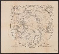
- Berghaus, Heinrich Karl Wilhelm, 1797-1884
Boell, William
Bowen & Co
Kane, Elisha Kent, 1820-1857
Petermann, A. (August), 1822-1878
- Published / Created:
- [1860]
- Call Number:
- 18 1860A
- Container / Volume:
- BRBL_00013
- Image Count:
- 1
- Resource Type:
- Maps, Atlases & Globes
- Found in:
- Beinecke Rare Book and Manuscript Library > A chart of the arctic regions : projected from Berghaus & Petermann, the charts of E.K. Kane, materials in the British Hydrographic office, etc. / eng. by W. Boell.
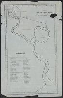
- Published / Created:
- 186-?]
- Call Number:
- 582 C38 186X
- Container / Volume:
- BRBL_00314
- Image Count:
- 1
- Resource Type:
- Maps, Atlases & Globes
- Found in:
- Beinecke Rare Book and Manuscript Library > A chart, Menam Chow P'aya or Bangkok River, from the British Survey &c.
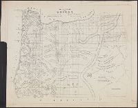
- Creator:
- United States. Surveyor General
- Published / Created:
- 1860
- Call Number:
- 846 1860A
- Container / Volume:
- BRBL_00621
- Image Count:
- 1
- Resource Type:
- Maps, Atlases & Globes
- Found in:
- Beinecke Rare Book and Manuscript Library > A diagram of Oregon.
- Published / Created:
- 1860?]
- Call Number:
- 796gme 1860
- Container / Volume:
- BRBL_00531
- Image Count:
- 1
- Resource Type:
- Maps, Atlases & Globes
- Found in:
- Beinecke Rare Book and Manuscript Library > A geographically correct map of the Red River, Sabine & Western Railway (under construction) and connections : showing distribution of pine forests (compiled from maps of U.S. government), also location of coal, iron, and oil deposits.
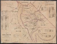
- Creator:
- Reed, Theron
- Published / Created:
- 1864
- Call Number:
- 844 Al65 1864
- Container / Volume:
- BRBL_00604
- Image Count:
- 1
- Resource Type:
- Maps, Atlases & Globes
- Found in:
- Beinecke Rare Book and Manuscript Library > A map of the Silver Mountain mining districts : including the territory of the proposed new county of Alpine [Calif.] / compiled by Theron Reed.
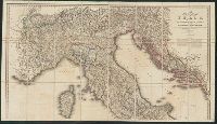
- Creator:
- Wyld, James, 1812-1887, cartographer
- Call Number:
- 40 1845B
- Container / Volume:
- BRBL_00200
- Image Count:
- 2
- Resource Type:
- Maps, Atlases & Globes
- Found in:
- Beinecke Rare Book and Manuscript Library > A new map of Italy, including the southern parts of Germany and the kingdom of Illyria : distinguishing their natural features and political divisions, post roads and stations with the number of posts between each station.
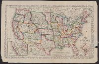
- Creator:
- Young, J. H. (James Hamilton)
- Published / Created:
- 1860, c1859.
- Call Number:
- 75 1859D
- Container / Volume:
- BRBL_00401
- Image Count:
- 1
- Resource Type:
- Maps, Atlases & Globes
- Found in:
- Beinecke Rare Book and Manuscript Library > A new map of the United States of America / by J.H. Young ; engraved by J.L. Hazzard & E. Yeager.