Search
You Searched For
Search Results
- Published / Created:
- [1572-1618?]
- Call Number:
- 36 B23 1618
- Container / Volume:
- BRBL_00122
- Image Count:
- 2
- Resource Type:
- Maps, Atlases & Globes
- Found in:
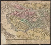
- Beinecke Rare Book and Manuscript Library > [Bardum. Braun and Hogenberg.]
- Published / Created:
- [1870?].
- Call Number:
- 764 B26 1870
- Container / Volume:
- BRBL_00453
- Image Count:
- 1
- Resource Type:
- Maps, Atlases & Globes
- Found in:
- Beinecke Rare Book and Manuscript Library > [Barnstable County, Mass.]
- Creator:
- Des Barres, Joseph F. W. (Joseph Frederick Wallet), 1722-1824
- Published / Created:
- Augt. 1st, 1781.
- Call Number:
- 734 S46 1781
- Container / Volume:
- BRBL_00380
- Image Count:
- 1
- Resource Type:
- Maps, Atlases & Globes
- Found in:
- Beinecke Rare Book and Manuscript Library > [Bay of Seven Islands, Québec].
- Creator:
- Straube, Julius
- Published / Created:
- [1875?]
- Call Number:
- 36 B45 1875B
- Container / Volume:
- BRBL_00122
- Image Count:
- 1
- Resource Type:
- Maps, Atlases & Globes
- Found in:
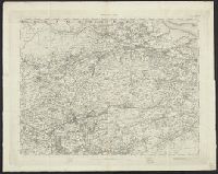
- Beinecke Rare Book and Manuscript Library > [Berlin, Germany].
- Published / Created:
- 1910
- Call Number:
- 59gme B639 1910
- Container / Volume:
- BRBL_00319
- Image Count:
- 1
- Resource Type:
- Maps, Atlases & Globes
- Found in:
- Beinecke Rare Book and Manuscript Library > [Bombay Tramway System.]
- Creator:
- Shurtleff, Arthur A. (Arthur Asahel), 1870-1957
- Published / Created:
- [1909]
- Call Number:
- 764 B65 1909E
- Container / Volume:
- BRBL_00456A
- Image Count:
- 1
- Resource Type:
- Maps, Atlases & Globes
- Found in:
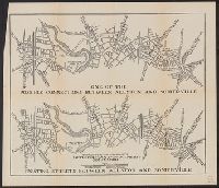
- Beinecke Rare Book and Manuscript Library > [Boston, Mass., Cambridge Bridge to North Station : proposed redevelopment] / Arthur A. Shurtleff.
- Creator:
- Shurtleff, Arthur A. (Arthur Asahel), 1870-1957
- Published / Created:
- [1909]
- Call Number:
- 764 B65 1909D
- Container / Volume:
- BRBL_00456A
- Image Count:
- 1
- Resource Type:
- Maps, Atlases & Globes
- Found in:
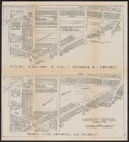
- Beinecke Rare Book and Manuscript Library > [Boston, Mass., Providence R.R. property : proposed redevelopment] / Arthur A. Shurtleff.
- Creator:
- Shurtleff, Arthur A. (Arthur Asahel), 1870-1957
- Published / Created:
- [1909]
- Call Number:
- 764 B65 1909G
- Container / Volume:
- BRBL_00456A
- Image Count:
- 1
- Resource Type:
- Maps, Atlases & Globes
- Found in:
- Beinecke Rare Book and Manuscript Library > [Boston, Mass., between Allston and Somerville : proposed redevelopment] / Arthur A. Shurtleff.
- Creator:
- Shurtleff, Arthur A. (Arthur Asahel), 1870-1957
- Published / Created:
- [1909]
- Call Number:
- 764 B65 1909F
- Container / Volume:
- BRBL_00456A
- Image Count:
- 1
- Resource Type:
- Maps, Atlases & Globes
- Found in:
- Beinecke Rare Book and Manuscript Library > [Boston, Mass., streets between Harvard and Wellington Bridges : proposed redevelopment] / Arthur A. Shurtleff.
- Published / Created:
- 1752
- Call Number:
- 356 B754 1752
- Container / Volume:
- BRBL_00114
- Image Count:
- 1
- Resource Type:
- Maps, Atlases & Globes
- Found in:
- Beinecke Rare Book and Manuscript Library > [Breslau] ...
- Published / Created:
- 191-.
- Call Number:
- 11hcf 1919D-19
- Container / Volume:
- BRBL_00010W
- Image Count:
- 1
- Resource Type:
- Maps, Atlases & Globes
- Found in:
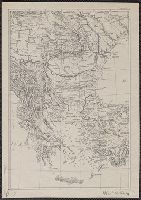
- Beinecke Rare Book and Manuscript Library > [Bulgaria and surrounding areas].
- Published / Created:
- 1917
- Call Number:
- 5 1917
- Container / Volume:
- BRBL_00271
- Image Count:
- 1
- Resource Type:
- Maps, Atlases & Globes
- Found in:
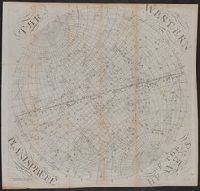
- Beinecke Rare Book and Manuscript Library > [Calendar chart of the night sky]
- Published / Created:
- 1873?]
- Call Number:
- 844 1873A
- Container / Volume:
- BRBL_00602
- Image Count:
- 1
- Resource Type:
- Maps, Atlases & Globes
- Found in:
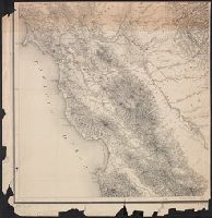
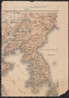
- Beinecke Rare Book and Manuscript Library > [California].
- Published / Created:
- [1840?]
- Call Number:
- 785 C17 1840
- Container / Volume:
- BRBL_00513
- Image Count:
- 1
- Resource Type:
- Maps, Atlases & Globes
- Found in:
- Beinecke Rare Book and Manuscript Library > [Cape Hatteras.]
- Creator:
- Dépôt de la guerre (France)
- Published / Created:
- 1837-1869.
- Call Number:
- 38 1848
- Container / Volume:
- BRBL_00755-759
- Image Count:
- 14
- Resource Type:
- Maps, Atlases & Globes
- Found in:
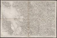
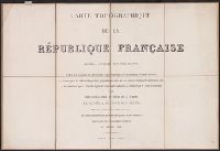
- Beinecke Rare Book and Manuscript Library > [Carte de France de l'Etat-Major] / levée par les Officiers du Corps d'Etat-Major ... gravée et publiée par le Dépôt de la Guerre.
- Creator:
- Dépôt de la guerre (France)
- Published / Created:
- 1837-1869.
- Call Number:
- 38 1848
- Container / Volume:
- BRBL_00747-762
- Image Count:
- 253
- Resource Type:
- Maps, Atlases & Globes
- Found in:
- Beinecke Rare Book and Manuscript Library > [Carte de France de l'Etat-Major] / levée par les Officiers du Corps d'Etat-Major ... gravée et publiée par le Dépôt de la Guerre.
- Published / Created:
- 191-.
- Call Number:
- 11hcf 1919-35
- Container / Volume:
- BRBL_00010K
- Image Count:
- 1
- Resource Type:
- Maps, Atlases & Globes
- Found in:
- Beinecke Rare Book and Manuscript Library > [Central Africa.]
- Published / Created:
- [1920-30?]
- Call Number:
- 89 1930
- Container / Volume:
- BRBL_00658
- Image Count:
- 1
- Resource Type:
- Maps, Atlases & Globes
- Found in:
- Beinecke Rare Book and Manuscript Library > [Central America]
- Published / Created:
- [1865?]
- Call Number:
- 304 1865
- Container / Volume:
- BRBL_00033
- Image Count:
- 1
- Resource Type:
- Maps, Atlases & Globes
- Found in:
- Beinecke Rare Book and Manuscript Library > [Central Europe].
- Published / Created:
- 1945
- Call Number:
- 304cbf 1945A
- Container / Volume:
- BRBL_00034A
- Image Count:
- 1
- Resource Type:
- Maps, Atlases & Globes
- Found in:
- Beinecke Rare Book and Manuscript Library > [Central Europe].
- Published / Created:
- 1633?]
- Call Number:
- 322 1633
- Container / Volume:
- BRBL_00059
- Image Count:
- 2
- Resource Type:
- Maps, Atlases & Globes
- Found in:
- Beinecke Rare Book and Manuscript Library > [Channel Islands]
- Published / Created:
- 186-?]
- Call Number:
- 582 C38 186XA
- Container / Volume:
- BRBL_00314
- Image Count:
- 1
- Resource Type:
- Maps, Atlases & Globes
- Found in:
- Beinecke Rare Book and Manuscript Library > [Chao Phraya River base map].
- Creator:
- Des Barres, Joseph F. W. (Joseph Frederick Wallet), 1722-1824
- Published / Created:
- 177-?]
- Call Number:
- 733cea G76 1776
- Container / Volume:
- BRBL_00379
- Image Count:
- 2
- Resource Type:
- Maps, Atlases & Globes
- Found in:
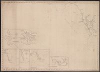
- Beinecke Rare Book and Manuscript Library > [Chart of Passamaquoddy Bay and Grand Manan island, New Brunswick].
- Creator:
- Månsson, Johan, -1659
- Call Number:
- Double Covers 303cea +1645
- Image Count:
- 7
- Resource Type:
- Maps, Atlases & Globes
- Found in:
- Beinecke Rare Book and Manuscript Library > [Chart of the Baltic Sea] / Siegismuntlus von Vogell fecit.
- Creator:
- Bordon, Benedetto, 1450-1530
- Published / Created:
- 1528?]
- Call Number:
- 57 1528
- Container / Volume:
- BRBL_00300
- Image Count:
- 2
- Resource Type:
- Maps, Atlases & Globes
- Found in:
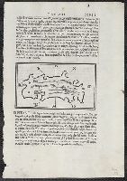
- Beinecke Rare Book and Manuscript Library > [Ciampagu ; Iaua Maggiore, Sondur, and Condur].
- Call Number:
- 766 N46 1917
- Container / Volume:
- BRBL_00473A
- Image Count:
- 15
- Resource Type:
- Maps, Atlases & Globes
- Found in:
- Beinecke Rare Book and Manuscript Library > [City of New Haven] 1913-1917.
- Creator:
- E. & G.W. Blunt (Firm)
- Published / Created:
- [between 1827? and 1850?]
- Call Number:
- 21cea 1830
- Container / Volume:
- BRBL_00016
- Image Count:
- 1
- Resource Type:
- Maps, Atlases & Globes
- Found in:
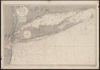
- Beinecke Rare Book and Manuscript Library > [Coast chart from Cape Hatteras to Cape Fear, North Carolina [cartographic material] : with insets of Cape Hatteras, Ocracoke Bar and Roads, Cape Lookout, Beaufort Harbour, Cape Fear, and the Cape Fear River] / engraved & printed by W. Hooker.
- Published / Created:
- 1919?]
- Call Number:
- 11hcf 1919B-30
- Container / Volume:
- BRBL_00010Q
- Image Count:
- 1
- Resource Type:
- Maps, Atlases & Globes
- Found in:
- Beinecke Rare Book and Manuscript Library > [Coast of the Adriatic Sea].
- Creator:
- Bruner, L. D.
- Published / Created:
- [1867?]
- Call Number:
- BrSides Elephant Folio 2018 14
- Image Count:
- 7
- Resource Type:
- Maps, Atlases & Globes
- Found in:
- Beinecke Rare Book and Manuscript Library > [Collection of five manuscript nautical charts of the World, the South Atlantic, and the East Indies with "Course indicator of U.S.S. 'Idaho'" drawn by L.D. Bruner].
- Published / Created:
- [1918]
- Call Number:
- 38hc R283 1918
- Container / Volume:
- BRBL_00173
- Image Count:
- 10
- Resource Type:
- Maps, Atlases & Globes
- Found in:
- Beinecke Rare Book and Manuscript Library > [Collection of maps related to raid of the Second Battalion Infantry Regiment 134 near Remenauville during the night of April 27/28 1918].
- Published / Created:
- [1780?]
- Call Number:
- 38 C71 1780
- Container / Volume:
- BRBL_00157
- Image Count:
- 1
- Resource Type:
- Maps, Atlases & Globes
- Found in:
- Beinecke Rare Book and Manuscript Library > [Colmar and Environs]
- Published / Created:
- ca. 163--1734]
- Call Number:
- 1973 Folio 18
- Image Count:
- 10
- Resource Type:
- Maps, Atlases & Globes
- Found in:
- Beinecke Rare Book and Manuscript Library > [Composite atlas of the world].
- Published / Created:
- 1918?]
- Call Number:
- 11hcf 1919D-48
- Image Count:
- 1
- Resource Type:
- Maps, Atlases & Globes
- Found in:
- Beinecke Rare Book and Manuscript Library > [Corpus Separatum di Fiume.]
- Published / Created:
- 1918?]
- Call Number:
- 11hcf 1919D-49
- Image Count:
- 1
- Resource Type:
- Maps, Atlases & Globes
- Found in:
- Beinecke Rare Book and Manuscript Library > [Corpus Separatum di Fiume.]
- Published / Created:
- [1916?].
- Call Number:
- 11hc 1916B
- Container / Volume:
- BRBL_00010C
- Image Count:
- 2
- Resource Type:
- Maps, Atlases & Globes
- Found in:
- Beinecke Rare Book and Manuscript Library > [Country between Paris and Strassbourg.]
- Published / Created:
- 1863
- Call Number:
- 783 Ap48 1863
- Container / Volume:
- BRBL_00510
- Image Count:
- 1
- Resource Type:
- Maps, Atlases & Globes
- Found in:
- Beinecke Rare Book and Manuscript Library > [Country south of juncture of Appomatox and James Rivers] / Engineer Dept. H.Q. Army of the Potomac.
- Published / Created:
- 1918
- Call Number:
- 11hcf 1919D-16
- Container / Volume:
- BRBL_00010W
- Image Count:
- 1
- Resource Type:
- Maps, Atlases & Globes
- Found in:
- Beinecke Rare Book and Manuscript Library > [Da Croda della Spia.]
- Published / Created:
- 1860
- Call Number:
- 464 1860
- Container / Volume:
- BRBL_00261
- Image Count:
- 1
- Resource Type:
- Maps, Atlases & Globes
- Found in:
- Beinecke Rare Book and Manuscript Library > [Dalmatia].
- Creator:
- Sprigade, Paul, 1863-1928
- Published / Created:
- 1909
- Call Number:
- 26911 1909B
- Container / Volume:
- BRBL_00023A
- Image Count:
- 1
- Resource Type:
- Maps, Atlases & Globes
- Found in:
- Beinecke Rare Book and Manuscript Library > [Deutsch-Neuguinea (Kaiser-Wilhelmsland u. Bismarck-Archipel)] / [bearbeitet v. P. Sprigade u. M. Moisel].
- Creator:
- Germany. Heer. Abteilung für Kriegskarten- und Vermessungswesen
- Published / Created:
- 1943
- Call Number:
- 685 1943B
- Container / Volume:
- BRBL_00351
- Image Count:
- 2
- Resource Type:
- Maps, Atlases & Globes
- Found in:
- Beinecke Rare Book and Manuscript Library > [Deutsche Heereskarte Afrika 1:200,000 (Tunesien-Algerien) Fumm Tatawin].
- Published / Created:
- 1911
- Call Number:
- 59gme B639 1911
- Container / Volume:
- BRBL_00319
- Image Count:
- 1
- Resource Type:
- Maps, Atlases & Globes
- Found in:
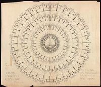
- Beinecke Rare Book and Manuscript Library > [Diagram of Tramway System : showing division into 12 fare sections.]
- Published / Created:
- [1640?]
- Call Number:
- 352 D64 1640
- Container / Volume:
- BRBL_00107
- Image Count:
- 2
- Resource Type:
- Maps, Atlases & Globes
- Found in:
- Beinecke Rare Book and Manuscript Library > [Dnieper River]
- Published / Created:
- [between 1829 and 1835]
- Call Number:
- 796ad 1830
- Container / Volume:
- BRBL_00716
- Image Count:
- 1
- Resource Type:
- Maps, Atlases & Globes
- Found in:
- Beinecke Rare Book and Manuscript Library > [Dominguez Grant]
- Creator:
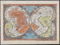
- Mercator, Gerhard, 1512-1594
- Published / Created:
- [192-?]
- Call Number:
- 11 1538
- Image Count:
- 1
- Resource Type:
- Maps, Atlases & Globes
- Found in:
- Beinecke Rare Book and Manuscript Library > [Double cordiform map of the world, 1538] / [cartographic material] / Joanni Drosio suo Gerardus Rupelmudan deducabat.
- Published / Created:
- [1780?]
- Call Number:
- 36 D935 1780
- Container / Volume:
- BRBL_00123
- Image Count:
- 1
- Resource Type:
- Maps, Atlases & Globes
- Found in:
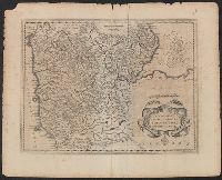
- Beinecke Rare Book and Manuscript Library > [Durlach and Environs.]
- Published / Created:
- 1890
- Call Number:
- 804fa P984 1890
- Container / Volume:
- BRBL_00545
- Image Count:
- 1
- Resource Type:
- Maps, Atlases & Globes
- Found in:
- Beinecke Rare Book and Manuscript Library > [East Part of Putnam County, Ohio].
- Published / Created:
- 1885?]
- Call Number:
- 3614 1885
- Container / Volume:
- BRBL_00135
- Image Count:
- 1
- Resource Type:
- Maps, Atlases & Globes
- Found in:
- Beinecke Rare Book and Manuscript Library > [East Prussia]
- Published / Created:
- 1705
- Call Number:
- 326 F776 1705
- Container / Volume:
- BRBL_00070
- Image Count:
- 1
- Resource Type:
- Maps, Atlases & Globes
- Found in:
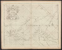
- Beinecke Rare Book and Manuscript Library > [Edinburgh Firth ... (Firth of Fourth).] To the Right Honorable Lord Chancellor of the Kingdom of Scotland. This Chart is humbly dedicated by Capt. Greenvile Collins. Hydrographer to the King.
- Published / Created:
- 1857-1867.
- Call Number:
- 326 1867
- Container / Volume:
- BRBL_00070
- Image Count:
- 2
- Resource Type:
- Maps, Atlases & Globes
- Found in:
- Beinecke Rare Book and Manuscript Library > [Edinburgh to Kirkinthllock]
- Published / Created:
- [19--?]
- Call Number:
- 615 1406/19XX
- Container / Volume:
- BRBL_00332
- Image Count:
- 1
- Resource Type:
- Maps, Atlases & Globes
- Found in:
- Beinecke Rare Book and Manuscript Library > [Egypt & Libya. From a manuscript copy of Ptolemy translated by Jacobo Angelo.]
- Published / Created:
- [1633?]
- Call Number:
- 32 1633
- Container / Volume:
- BRBL_00042
- Image Count:
- 7
- Resource Type:
- Maps, Atlases & Globes
- Found in:
- Beinecke Rare Book and Manuscript Library > [England & Wales]
- Published / Created:
- 1723
- Call Number:
- 492 1723
- Container / Volume:
- BRBL_00270
- Image Count:
- 2
- Resource Type:
- Maps, Atlases & Globes
- Found in:
- Beinecke Rare Book and Manuscript Library > [Engraved map of the coasts of the Black sea].
- Published / Created:
- 1918
- Call Number:
- 11hc 1918-Z21
- Container / Volume:
- BRBL_00010G
- Image Count:
- 1
- Resource Type:
- Maps, Atlases & Globes
- Found in:
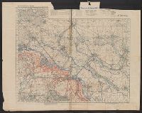
- Beinecke Rare Book and Manuscript Library > [Erkundungs-karte nach Truppenmeldungen und Fliegerbildern Gruppe Vailly Ic, IId. : Zusammendruck Laffaux.]
- Creator:
- Sanson, Nicolas, 1600-1667, cartographer.
- Published / Created:
- ca. 1702?]
- Call Number:
- 1973 Folio 18
- Image Count:
- 1
- Resource Type:
- Maps, Atlases & Globes
- Found in:
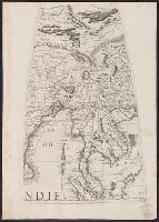
- Beinecke Rare Book and Manuscript Library > [Est]ats de L'Empire du Grand Seigneur des Turcs Europe, en Asie, et en Afrique [cartographic material] : divise en tous ses Beglerbeglicz ou Gouvernements ou sont aussi remarques les Estats qui luy sont Tributaires dresse sur les plus nouvelles relations / par le Sr. Sanson ...
- Creator:
- Sanson, Nicolas, 1600-1667
- Published / Created:
- 1700?]
- Call Number:
- 501 1700
- Container / Volume:
- BRBL_00275
- Image Count:
- 1
- Resource Type:
- Maps, Atlases & Globes
- Found in:
- Beinecke Rare Book and Manuscript Library > [Est]ats de L'Empire du Grand Seigneur des Turcs en Europe, en Asie, et en Afrique : divise en touts ses beglerbeglicz ou gouvernements ou sont aussi remarques les Estats qui luy sont Tributaires dresse sur les plus nouvelles relations / par le Sr. Sanson
- Published / Created:
- [1870]
- Call Number:
- 30ed 1870
- Container / Volume:
- BRBL_00037B
- Image Count:
- 1
- Resource Type:
- Maps, Atlases & Globes
- Found in:
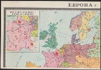
- Beinecke Rare Book and Manuscript Library > [Europe Ethnographic].
- Published / Created:
- [19--]
- Call Number:
- 30f 1914
- Container / Volume:
- BRBL_00037B
- Image Count:
- 4
- Resource Type:
- Maps, Atlases & Globes
- Found in:
- Beinecke Rare Book and Manuscript Library > [Europe in 1870-1914].
- Published / Created:
- 1940
- Call Number:
- 30hd 1940I
- Container / Volume:
- BRBL_00038
- Image Count:
- 1
- Resource Type:
- Maps, Atlases & Globes
- Found in:
- Beinecke Rare Book and Manuscript Library > [Europe-Western Battle Lines].
- Published / Created:
- [1910?]
- Call Number:
- 30 1910
- Container / Volume:
- BRBL_00032
- Image Count:
- 1
- Resource Type:
- Maps, Atlases & Globes
- Found in:
- Beinecke Rare Book and Manuscript Library > [Europe].
- Published / Created:
- 1919?]
- Call Number:
- 11hcf 1919B-34
- Container / Volume:
- BRBL_00010Q
- Image Count:
- 1
- Resource Type:
- Maps, Atlases & Globes
- Found in:
- Beinecke Rare Book and Manuscript Library > [Europe].
- Creator:
- Löwe, Cornelius
Pharus-Verlag
United States. Office of Strategic Services. Geography Division. Map Information Section
- Published / Created:
- ca. 1942]
- Call Number:
- 36 L65 1942
- Container / Volume:
- BRBL_00125
- Image Count:
- 2
- Resource Type:
- Maps, Atlases & Globes
- Found in:
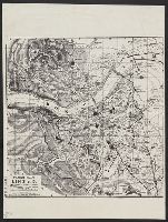
- Beinecke Rare Book and Manuscript Library > [Facsimile map of Linz, Austria].
- Published / Created:
- ca. 1942]
- Call Number:
- 36 Sa12 1942
- Container / Volume:
- BRBL_00126
- Image Count:
- 2
- Resource Type:
- Maps, Atlases & Globes
- Found in:
- Beinecke Rare Book and Manuscript Library > [Facsimile map of Saarbrücken, Germany].
- Published / Created:
- 191-?]
- Call Number:
- 11hcf 1919D-17
- Container / Volume:
- BRBL_00010W
- Image Count:
- 1
- Resource Type:
- Maps, Atlases & Globes
- Found in:
- Beinecke Rare Book and Manuscript Library > [Fiume].
- Published / Created:
- 1942?]
- Call Number:
- 38gmb 1942
- Container / Volume:
- BRBL_00170
- Image Count:
- 1
- Resource Type:
- Maps, Atlases & Globes
- Found in:
- Beinecke Rare Book and Manuscript Library > [France, highways].
- Published / Created:
- 1835
- Call Number:
- 3627 F98 1835
- Image Count:
- 1
- Resource Type:
- Maps, Atlases & Globes
- Found in:
- Beinecke Rare Book and Manuscript Library > [Füssen and Environs] 1835.
- Call Number:
- Gfp94 +Gi597
- Collection Title:
- Geografia; cioè, Descrittione vniversale della terra. Partita in due volumi, nel primo de' quali si
- Image Count:
- 1
- Resource Type:
- Maps, Atlases & Globes
- Found in:
- Beinecke Rare Book and Manuscript Library > [Geographia. Italian]
- Call Number:
- 1977 +379
- Collection Title:
- Geografia; cioè, Descrittione vniversale della terra. Partita in due volumi, nel primo de' quali si
- Image Count:
- 1
- Resource Type:
- Maps, Atlases & Globes
- Found in:
- Beinecke Rare Book and Manuscript Library > [Geographia. Italian]
- Call Number:
- 1977 +435
- Collection Title:
- Geografia; cioè, Descrittione vniversale della terra. Partita in due volumi, nel primo de' quali si
- Image Count:
- 1
- Resource Type:
- Maps, Atlases & Globes
- Found in:
- Beinecke Rare Book and Manuscript Library > [Geographia. Italian]
- Call Number:
- 1977 +435
- Collection Title:
- Geografia; cioè, Descrittione vniversale della terra. Partita in due volumi, nel primo de' quali si
- Image Count:
- 1
- Resource Type:
- Maps, Atlases & Globes
- Found in:
- Beinecke Rare Book and Manuscript Library > [Geographia. Italian]
- Published / Created:
- 1940
- Call Number:
- 7715cea 1940
- Image Count:
- 1
- Resource Type:
- Maps, Atlases & Globes
- Found in:
- Beinecke Rare Book and Manuscript Library > [German Chart No. 455] Atlantischer Ozean Ostküste von Nordamerika Block Island Bis New York.
- Published / Created:
- [1919?].
- Call Number:
- 11hcf 1919A-5
- Container / Volume:
- BRBL_00010N
- Image Count:
- 1
- Resource Type:
- Maps, Atlases & Globes
- Found in:
- Beinecke Rare Book and Manuscript Library > [Germany : the German propositions after World War I.]
- Creator:
- Coronelli, Vincenzo, 1650-1718
- Published / Created:
- 1693-1707]
- Call Number:
- 50 1693 41
- Container / Volume:
- BRBL_00735
- Image Count:
- 1
- Resource Type:
- Maps, Atlases & Globes
- Found in:
- Beinecke Rare Book and Manuscript Library > [Globe gore covering Asia]
- Creator:
- Coronelli, Vincenzo, 1650-1718
- Published / Created:
- 1693-1707]
- Call Number:
- 911 1693 15
- Container / Volume:
- BRBL_00735
- Image Count:
- 1
- Resource Type:
- Maps, Atlases & Globes
- Found in:
- Beinecke Rare Book and Manuscript Library > [Globe gore covering Brazil]
- Creator:
- Coronelli, Vincenzo, 1650-1718
- Published / Created:
- 1693-1707]
- Call Number:
- 556 1693 40
- Container / Volume:
- BRBL_00735
- Image Count:
- 1
- Resource Type:
- Maps, Atlases & Globes
- Found in:
- Beinecke Rare Book and Manuscript Library > [Globe gore covering East Asia]
- Creator:
- Coronelli, Vincenzo, 1650-1718
- Published / Created:
- 1693-1707]
- Call Number:
- 23 1693 7
- Container / Volume:
- BRBL_00735
- Image Count:
- 1
- Resource Type:
- Maps, Atlases & Globes
- Found in:
- Beinecke Rare Book and Manuscript Library > [Globe gore covering Pacific Ocean]
- Creator:
- Coronelli, Vincenzo, 1650-1718
- Published / Created:
- 1693-1707]
- Call Number:
- 935 1693 13
- Container / Volume:
- BRBL_00735
- Image Count:
- 1
- Resource Type:
- Maps, Atlases & Globes
- Found in:
- Beinecke Rare Book and Manuscript Library > [Globe gore covering South America]
- Creator:
- Coronelli, Vincenzo, 1650-1718
- Published / Created:
- 1693-1707]
- Call Number:
- 71 1693 31
- Container / Volume:
- BRBL_00735
- Image Count:
- 1
- Resource Type:
- Maps, Atlases & Globes
- Found in:
- Beinecke Rare Book and Manuscript Library > [Globe gore covering central North America]
- Creator:
- Coronelli, Vincenzo, 1650-1718
- Published / Created:
- 1693-1707]
- Call Number:
- 655 1693 25
- Container / Volume:
- BRBL_00735
- Image Count:
- 1
- Resource Type:
- Maps, Atlases & Globes
- Found in:
- Beinecke Rare Book and Manuscript Library > [Globe gore covering northwest Africa]
- Creator:
- Coronelli, Vincenzo, 1650-1718
- Published / Created:
- 1693-1707]
- Call Number:
- 64 1693 19
- Container / Volume:
- BRBL_00735
- Image Count:
- 1
- Resource Type:
- Maps, Atlases & Globes
- Found in:
- Beinecke Rare Book and Manuscript Library > [Globe gore covering southern Africa]
- Creator:
- Coronelli, Vincenzo, 1650-1718
- Published / Created:
- 1693-1707]
- Call Number:
- 52 1693 44
- Container / Volume:
- BRBL_00735
- Image Count:
- 1
- Resource Type:
- Maps, Atlases & Globes
- Found in:
- Beinecke Rare Book and Manuscript Library > [Globe gore covering the Arabian Peninsula]
- Creator:
- Coronelli, Vincenzo, 1650-1718
- Published / Created:
- 1693-1707]
- Call Number:
- 85 1693 11
- Container / Volume:
- BRBL_00735
- Image Count:
- 1
- Resource Type:
- Maps, Atlases & Globes
- Found in:
- Beinecke Rare Book and Manuscript Library > [Globe gore covering the Caribbean Sea]
- Creator:
- Coronelli, Vincenzo, 1650-1718
- Published / Created:
- 1693-1707]
- Call Number:
- 23 1693 9
- Container / Volume:
- BRBL_00735
- Image Count:
- 1
- Resource Type:
- Maps, Atlases & Globes
- Found in:
- Beinecke Rare Book and Manuscript Library > [Globe gore covering the Pacific Ocean and New Zealand]
- Creator:
- Coronelli, Vincenzo, 1650-1718
- Published / Created:
- 1693-1707]
- Call Number:
- 23 1693 12
- Container / Volume:
- BRBL_00735
- Image Count:
- 1
- Resource Type:
- Maps, Atlases & Globes
- Found in:
- Beinecke Rare Book and Manuscript Library > [Globe gore covering the Pacific Ocean and South America]
- Creator:
- Coronelli, Vincenzo, 1650-1718
- Published / Created:
- 1693-1707]
- Call Number:
- 299 1693 22
- Container / Volume:
- BRBL_00735
- Image Count:
- 1
- Resource Type:
- Maps, Atlases & Globes
- Found in:
- Beinecke Rare Book and Manuscript Library > [Globe gore showing Madagascar and surrounding area]
- Creator:
- Coronelli, Vincenzo, 1650-1718
- Published / Created:
- 1693-1707]
- Call Number:
- 21 1693 27
- Container / Volume:
- BRBL_00735
- Image Count:
- 1
- Resource Type:
- Maps, Atlases & Globes
- Found in:
- Beinecke Rare Book and Manuscript Library > [Globe gore showing showing the North Atlantic Ocean]
- Published / Created:
- 1917
- Call Number:
- 11hc 1918-Z22
- Container / Volume:
- BRBL_00010G
- Image Count:
- 1
- Resource Type:
- Maps, Atlases & Globes
- Found in:
- Beinecke Rare Book and Manuscript Library > [Grabenkarte der 7. Armee. Bl.16. Jouy.]
- Published / Created:
- 1918
- Call Number:
- 11hc 1918-Z7
- Image Count:
- 1
- Resource Type:
- Maps, Atlases & Globes
- Found in:
- Beinecke Rare Book and Manuscript Library > [Gruppenkarte Korps Schmettow. Zusammendruck Romain.]
- Published / Created:
- 1880?]
- Call Number:
- 3627 G92 1880
- Image Count:
- 2
- Resource Type:
- Maps, Atlases & Globes
- Found in:
- Beinecke Rare Book and Manuscript Library > [Grünwald and Environs].
- Published / Created:
- [1780?]
- Call Number:
- 36 H362 1780
- Container / Volume:
- BRBL_00124
- Image Count:
- 1
- Resource Type:
- Maps, Atlases & Globes
- Found in:
- Beinecke Rare Book and Manuscript Library > [Heidelburg and Environs.]
- Published / Created:
- December 1st, 1757.
- Call Number:
- 5 1757
- Container / Volume:
- BRBL_00271
- Image Count:
- 5
- Resource Type:
- Maps, Atlases & Globes
- Found in:
- Beinecke Rare Book and Manuscript Library > [Hemispherical maps and astronomical charts.]
- Published / Created:
- [1915?]
- Call Number:
- 427gmb 1915
- Container / Volume:
- BRBL_00247
- Image Count:
- 2
- Resource Type:
- Maps, Atlases & Globes
- Found in:
- Beinecke Rare Book and Manuscript Library > [Hözels Automobilkarten]. Blatt XVII - Klagenfurt-Hofgastein.
- Published / Created:
- [1729?]
- Call Number:
- 534 1729
- Container / Volume:
- BRBL_00289
- Image Count:
- 1
- Resource Type:
- Maps, Atlases & Globes
- Found in:
- Beinecke Rare Book and Manuscript Library > [Ibrahim Mutafarrikah's engraved map of the Persian Empire, showing also the Caucasus, southern Russia, Transcaucasian Turkestan, Iraq and part of Anatolia ... A.H. 1142 - A.D. 1729/30] [In Turkish].
- Creator:
- Benitz, A.
Fernandez, Carmelo.
Laplante, Edard de
- Published / Created:
- [1840]
- Call Number:
- 1973 Folio 105
- Collection Title:
- Atlas fisico y politico de la Republica de Venezuela ... por ... Agustin Codazzi ...
- Image Count:
- 9
- Resource Type:
- Maps, Atlases & Globes
- Found in:
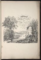
- Beinecke Rare Book and Manuscript Library > [Illustrated title page and selected text]
- Published / Created:
- 1660?]
- Call Number:
- 5 1660
- Container / Volume:
- BRBL_00723
- Image Count:
- 1
- Resource Type:
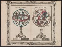
- Maps, Atlases & Globes
- Found in:
- Beinecke Rare Book and Manuscript Library > [Illustration of celestial spheres of Copernicus and Ptolemy].
- Published / Created:
- 1660?]
- Call Number:
- 6 1660
- Container / Volume:
- BRBL_00723
- Image Count:
- 1
- Resource Type:
- Maps, Atlases & Globes
- Found in:
- Beinecke Rare Book and Manuscript Library > [Illustration of terrestrial and celestial globes].
- Published / Created:
- 19--.
- Call Number:
- 565 1905X
- Container / Volume:
- BRBL_00299
- Image Count:
- 1
- Resource Type:
- Maps, Atlases & Globes
- Found in:
- Beinecke Rare Book and Manuscript Library > [Index map for Campaign in Manchuria maps.]
- Creator:
- Survey of India.
- Published / Created:
- 1827-1904.
- Call Number:
- Series 59 1827
- Image Count:
- 61
- Resource Type:
- Maps, Atlases & Globes
- Found in:
- Beinecke Rare Book and Manuscript Library > [Indian atlas 1:253 440, full sheets] / Survey of India.
- Published / Created:
- 1875?]
- Call Number:
- 428 IN7 1875
- Container / Volume:
- BRBL_00248
- Image Count:
- 1
- Resource Type:
- Maps, Atlases & Globes
- Found in:
- Beinecke Rare Book and Manuscript Library > [Innsbruck and Environs].
- Published / Created:
- [1878?]
- Call Number:
- 428 IN7 1878
- Container / Volume:
- BRBL_00248
- Image Count:
- 1
- Resource Type:
- Maps, Atlases & Globes
- Found in:
- Beinecke Rare Book and Manuscript Library > [Innsbruck].
- Creator:
- Sanborn Map Company
- Published / Created:
- [1918]
- Call Number:
- 766 W688 1918
- Container / Volume:
- BRBL_00502
- Image Count:
- 7
- Resource Type:
- Maps, Atlases & Globes
- Found in:
- Beinecke Rare Book and Manuscript Library > [Insurance maps of Wilmington, Delaware].