Skip to search
Skip to main content
Skip to first result
Search
You Searched For
Resource Type
Maps, Atlases & Globes
New Search
Search Results
Creator:
Published / Created:
1880
Call Number:
331 Am88 1880
Container / Volume:
BRBL_00079
Image Count:
2
Resource Type:
Maps, Atlases & Globes
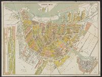
Alternative Title:
Platte grond van Amsterdam in 1880
Description:
Inzet: [1.] Vondels park ; [2.] Plan van uitbreiding der stad, vastgesteld in 1874., Verso: Gids voor de bezoekers van Amsterdam., and Verso: Lijst van straten, grachten enz.
Publisher:
Funke,
Subject (Geographic):
Amsterdam (Netherlands)--Maps
Found in:
Beinecke Rare Book and Manuscript Library > Amsterdam in 1880 / A. Braakensiek, fec.
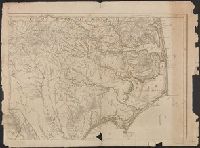
Published / Created:
1775
Call Number:
7855 1775C
Container / Volume:
BRBL_00515
Image Count:
1
Resource Type:
Maps, Atlases & Globes
Description:
Insets are described in booklet, Printed for Robt. Sayer and J. Bennett ... 1775., See booklet 785.1966 filed in corridor: W.P. Cumming, "North Carolina in Maps" ( Raleigh: State Dept. of Archives and History, 1966), Plate VIII., and See Roll Map 7855 +1794 for
Subject (Geographic):
North Carolina--Maps--Early works to 1800 and South Carolina--Maps--Early works to 1800
Found in:
Beinecke Rare Book and Manuscript Library > An Accurate Map of North and South Carolina With Their Indian Frontiers, Shewing ... from Actual Surveys by Henry Mouzon and Others.
Published / Created:
1749
Call Number:
3214 1749
Container / Volume:
BRBL_00056
Image Count:
1
Resource Type:
Maps, Atlases & Globes
Description:
Preliminary record.
Subject (Geographic):
Sussex (England)--Maps--Early works to 1800
Found in:
Beinecke Rare Book and Manuscript Library > An Accurate Map of the County of Sussex ... by Eman: Bowen ... 1749.
Published / Created:
[1778]
Call Number:
11 1778
Container / Volume:
BRBL_00005
Image Count:
1
Resource Type:
Maps, Atlases & Globes
Description:
Preliminary record.
Subject (Geographic):
World--Maps--Early works to 1800
Found in:
Beinecke Rare Book and Manuscript Library > An Accurate Map of the World ... By T. Conder. Engraved for Moore's New and Compleat Collection of Voyages and Travels.
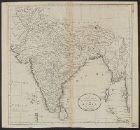
Published / Created:
1795].
Call Number:
59 1795B
Container / Volume:
BRBL_00316
Image Count:
1
Resource Type:
Maps, Atlases & Globes
Description:
From Carey's American Edition of Guthrie's Geography Improved.
Publisher:
Mathew Carey,
Subject (Geographic):
India--Maps--Early works to 1800
Found in:
Beinecke Rare Book and Manuscript Library > An Accurate map of Hindostan or India, from the Best Authorities. J.T. Scott, Sculp.
Published / Created:
1760?]
Call Number:
303 1760
Container / Volume:
BRBL_00033
Image Count:
1
Resource Type:
Maps, Atlases & Globes
Description:
Text on corner of Map.
Subject (Geographic):
Baltic Sea--Maps--Early works to 1800
Found in:
Beinecke Rare Book and Manuscript Library > An Exact chart of the North Sea ... Sold by W. Mount & T Page ...
Published / Created:
[1875?]
Call Number:
774J 1875
Container / Volume:
BRBL_00502
Image Count:
1
Resource Type:
Maps, Atlases & Globes
Alternative Title:
Historical map of Pennsylvania
Description:
Text attached. Various data on margin.
Publisher:
The Historical Society of Pennsylvania,
Subject (Geographic):
Pennsylvania--Maps
Found in:
Beinecke Rare Book and Manuscript Library > An Historical map of Pennsylvania showing the Indian Names of Streams and Villages, and paths of travel; The Sites of Old Forts and Battle Fields; The Sucessive Purchases from the Indians; and the names and dates of Counties and County Towns, with Tables
Published / Created:
[1795]
Call Number:
761 1795
Container / Volume:
BRBL_00447
Image Count:
2
Resource Type:
Maps, Atlases & Globes
Publisher:
O. Carleton & J. Norman,
Subject (Geographic):
Maine--Maps--Early works to 1800
Found in:
Beinecke Rare Book and Manuscript Library > An accurate Map of the District of Maine Being part of the Commonwealth of Massachusetts ...
Published / Created:
[1760]
Call Number:
361hc 1760
Container / Volume:
BRBL_00135
Image Count:
1
Resource Type:
Maps, Atlases & Globes
Subject (Geographic):
Prussia (Duchy)--Maps--Early works to 1800
Found in:
Beinecke Rare Book and Manuscript Library > An accurate Map of the Seat of War in the Empire of Germany as also in the Kingdom of Prussia with the adjacent Countries. By T. Kitchin Geogr.
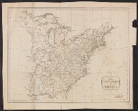
Published / Created:
1794
Call Number:
755 1794C
Container / Volume:
BRBL_00436
Image Count:
1
Resource Type:
Maps, Atlases & Globes
Description:
L.C. 863-11.
Publisher:
H.D. Symonds,
Subject (Geographic):
East (U.S.)--Maps--Early works to 1800
Found in:
Beinecke Rare Book and Manuscript Library > An accurate Map of the United States of America according to the Treaty of Peace of 1783. Russell del et Sculp.
Branch:v1.61.6 ,Deployed:2024-06-12T09:55:31-04:00