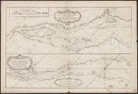
Sheet 1: "Dupuis Quebec jusqu'a Mantane et Riviere des Outards," also, above, on the same plate, "Partie du cours ... depuis Quebec jusqu'au Cap aux Oyes". and Sheet 2: [Riviere des Outardes to Anticost].
Guide de voyage à Constantinople sur le Danube and Plan de Constantinople
Description:
Historic Maps copy originally folded in paper wrapper 18 x 12 cm., Inset: Plan de Constantinople (scale [ca. 1:50,000])., NjP, Publication date suggested by advertisements on verso of map., and Relief shown by hachures.
Publisher:
Chez Artaria & Co.,
Subject (Geographic):
Balkan Peninsula--Maps, Danube River Valley--Maps, Danube River--Maps, and Istanbul (Turkey)--Maps
"Suppl. au Tome IX No. 16"--Lower left margin., Appears in Abbe Prevost's Histoire generale des voyages., In French., Includes key., Oriented with north to the right., Relief shown pictorially., and Shows farmland, fortifications, homes, places of worship, and vegetation.
Publisher:
s.n.,
Subject (Geographic):
Tranquebar (India)--Maps--Early works to 1800
Subject (Name):
Prévost, abbé, 1697-1763. Histoire generale des voyages
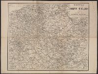
"Gravé et imprime par Charaire, à Sceaux." and Shows cities, towns, roads, waterways, and the location of troops and fortifications along the French front.
"Gravé et imprime par Charaire, à Sceaux." and Shows cities, towns, roads, waterways, and the location of troops and fortifications along the French front.