Search
You Searched For
Search Results
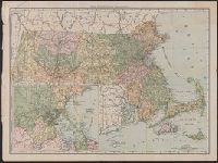
- Creator:
- Colton, J. H. (Joseph Hutchins), 1800-1893
- Published / Created:
- 1860
- Call Number:
- 764 1860
- Container / Volume:
- BRBL_00453
- Image Count:
- 1
- Resource Type:
- Maps, Atlases & Globes
- Found in:
- Beinecke Rare Book and Manuscript Library > Colton's Massachusetts and Rhode Island.
- Creator:
- Geo. H. Walker & Co
- Published / Created:
- c1891.
- Call Number:
- 764 1891A
- Container / Volume:
- BRBL_00453
- Image Count:
- 1
- Resource Type:
- Maps, Atlases & Globes
- Found in:
- Beinecke Rare Book and Manuscript Library > Massachusetts atlas plate no. 26.
- Creator:
- Geo. H. Walker & Co
- Published / Created:
- c1891.
- Call Number:
- 764 1891W
- Container / Volume:
- BRBL_00453
- Image Count:
- 1
- Resource Type:
- Maps, Atlases & Globes
- Found in:
- Beinecke Rare Book and Manuscript Library > Massachusetts atlas plate no. 27.
- Creator:
- Rand McNally and Company
- Published / Created:
- 1891
- Call Number:
- 764 1891
- Container / Volume:
- BRBL_00453
- Image Count:
- 1
- Resource Type:
- Maps, Atlases & Globes
- Found in:
- Beinecke Rare Book and Manuscript Library > Rand McNally & Co.'s Massachusetts.
- Published / Created:
- 1661
- Call Number:
- 764ad D728 1661
- Container / Volume:
- BRBL_00711
- Image Count:
- 1
- Resource Type:
- Maps, Atlases & Globes
- Found in:
- Beinecke Rare Book and Manuscript Library > [Manuscript map of Dorchester, Massachusetts].
- Creator:
- Dorman, Moses, author.
- Published / Created:
- 1830
- Call Number:
- 764 An23 1830
- Image Count:
- 1
- Resource Type:
- Maps, Atlases & Globes
- Description:
- portion of the City of Lawrence, Massachusetts.
- Subject (Topic):
- Landowners--Massachusetts--Andover
- Found in:
- Beinecke Rare Book and Manuscript Library > A plan of Andover taken for the town / by Moses Dorman, Jr.
- Creator:
- Ferguson, W. E
- Published / Created:
- 1850
- Call Number:
- 764gme 1850
- Container / Volume:
- BRBL_00462
- Image Count:
- 1
- Resource Type:
- Maps, Atlases & Globes
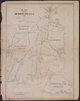
- Abstract:
- Map of eastern Massachusetts covering
- Subject (Topic):
- Railroads--Massachusetts--Maps
- Found in:
- Beinecke Rare Book and Manuscript Library > Map of the Old Colony Rail Road with its branches & connecting roads, prepared under the direction of the Committee of Investigation, Jany. 1850, S. Dwight Eaton, Engr.
- Creator:
- Dearborn, Benjamin, 1754-1838
- Published / Created:
- [1814]
- Call Number:
- 764 B65 1814A
- Container / Volume:
- BRBL_00455
- Image Count:
- 2
- Resource Type:
- Maps, Atlases & Globes
- Description:
- Removed from Massachusetts House
- Subject (Topic):
- Drainage--Massachusetts--Boston
- Found in:
- Beinecke Rare Book and Manuscript Library > A plan of those parts of Boston and the towns in its vicinity : with the waters and flats adjacent which are immediately or remotely connected with the contemplated design of erecting perpetual tide-mills.
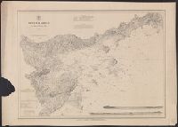
- Creator:
- United States Coast Survey
- Published / Created:
- [1875]
- Call Number:
- 764cea SA32 1875
- Container / Volume:
- BRBL_00461
- Image Count:
- 1
- Resource Type:
- Maps, Atlases & Globes
- Subject (Topic):
- Harbors--Massachusetts--Salem--Maps
- Found in:
- Beinecke Rare Book and Manuscript Library > Salem harbor, Massachusetts / United States Coast Survey ; topography by F. Dankworth ; sand by H.M. Knight ; lettering by J. Knight & S.E. Stull ; views by G. McCoy.
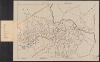
- Creator:
- Geo. H. Walker & Co
- Published / Created:
- c1904.
- Call Number:
- 764gmb T193 1904
- Container / Volume:
- BRBL_00462
- Image Count:
- 1
- Resource Type:
- Maps, Atlases & Globes
- Alternative Title:
- Massachusetts
- Found in:
- Beinecke Rare Book and Manuscript Library > City of Taunton.