Skip to search
Skip to main content
Skip to first result
Search
You Searched For
Date
-
"Michigan"
Resource Type
Maps, Atlases & Globes
New Search
Search Results
Published / Created:
[1859?] and [between 1880 and 1889?]
Call Number:
BrSides Folio 2018 138
Image Count:
1
Resource Type:
Maps, Atlases & Globes
Alternative Title:
Map of a portion of Point Keweenaw, Lake Superior
Description:
Backed with linen. Manuscript annotations on map. Manuscript title on verso: Copper Harbour & Eagle Harbour. From the Richard H. Rickard Papers. and In upper left corner: 59.
Publisher:
[publisher not identified],
Subject (Geographic):
Michigan --Keweenaw County
Subject (Name):
Delaware Mining Company of Michigan
Subject (Topic):
Copper mines and mining--Michigan
Found in:
Beinecke Rare Book and Manuscript Library > Map of a portion of Point Keweenaw, L.S. : showing the lands &c. of the Pennsylvania & Delaware Mining Co's.
Creator:
Published / Created:
[1839?]
Call Number:
811 1839A
Container / Volume:
BRBL_00552
Image Count:
4
Resource Type:
Maps, Atlases & Globes
Alternative Title:
Map of Michigan and part of Wisconsin
Description:
"Entered according to Act of Congress July 10, 1839 by David H. Burr in the clerk's office of the District Court of the District of Columbia." and Prime meridians: Greenwich and Washington.
Publisher:
J. Arrowsmith,
Subject (Geographic):
Michigan --Maps
Subject (Name):
Arrowsmith, John, 1790-1873
Found in:
Beinecke Rare Book and Manuscript Library > Map of Michigan & part of Wisconsin Territory : exhibiting the post offices, post roads, canals, rail roads, &c. / by David H. Burr.
Creator:
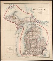
Published / Created:
[1863]
Call Number:
811 D48 1863
Container / Volume:
BRBL_00553
Image Count:
2
Resource Type:
Maps, Atlases & Globes
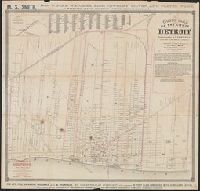
Alternative Title:
Guide map of the city of Detroit showing location of hotels, churches, schools, railroad depots and all places of interest
Description:
, Michigan Central, and Michigan Southern
Publisher:
Published by S. Farmer & Co.,
Subject (Geographic):
Detroit (Mich.)--Maps.
Subject (Name):
Mendel, Edward, 1827-1884 and Robinson, Eugene
Found in:
Beinecke Rare Book and Manuscript Library > Guide map of the city of Detroit / drawn by Eugene Robinson, city surveyor ; lith. by Ed Mendel.
Published / Created:
[between 1875 and 1900?]
Call Number:
BrSides 2018 155
Image Count:
1
Resource Type:
Maps, Atlases & Globes
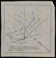
Description:
"Magnolia adversed Ypsilanti on conflicts marked A and B, and did not adverse Bullion. Piece marked C is in dispute between the Ypsilanti and Bullion.", From the Richard H. Rickard Papers., and Title devised by cataloger.
Subject (Name):
Rickard, Richard H.,---1885--Ownership.
Subject (Topic):
Copper mines and mining--Michigan --Maps.
Found in:
Beinecke Rare Book and Manuscript Library > [Manuscript map of mine locations in Michigan].
Branch:v1.61.8 ,Deployed:2024-06-20T11:15:02-04:00