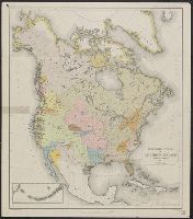
Search
You Searched For
Search Results
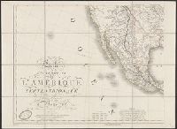
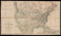
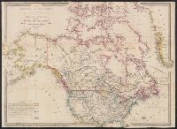
- Creator:
- Arrowsmith, Aaron, 1750-1823
- Published / Created:
- [betw. 1804 and 1811?]
- Call Number:
- 70 1808
- Container / Volume:
- BRBL_00358
- Image Count:
- 4
- Resource Type:
- Maps, Atlases & Globes
- Found in:
- Beinecke Rare Book and Manuscript Library > Map of America / by A. Arrowsmith ; engraved by W. West, the hills by H. Wilson.
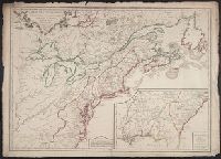
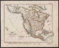
- Published / Created:
- 1906
- Call Number:
- 71 1906A
- Container / Volume:
- BRBL_00371
- Image Count:
- 2
- Resource Type:
- Maps, Atlases & Globes
- Subject (Topic):
- Geology--North America--Maps
- Found in:
- Beinecke Rare Book and Manuscript Library > Carte géologique de l'Amérique du nord / dressée d'apres les sources officielles des Etats Unis, du Canada, del la République du Mexique, de la Commission du Chemin de Fer Intercontinental, etc. ; Henry Ganett, géographe ; Bailey Willis, geologue.
- Creator:
- Hall, Sidney
- Published / Created:
- [between 1825 and 1845]
- Call Number:
- BrSides 2018 137
- Image Count:
- 1
- Resource Type:
- Maps, Atlases & Globes
- Subject (Geographic):
- North America--Maps
- Subject (Topic):
- Indians of North America--Maps
- Found in:
- Beinecke Rare Book and Manuscript Library > North America / engraved by Sidney Hall.
- Published / Created:
- [1867?]
- Call Number:
- 826 1866
- Container / Volume:
- BRBL_00577
- Image Count:
- 1
- Resource Type:
- Maps, Atlases & Globes
- Subject (Topic):
- Indians of North America--Maps
- Found in:
- Beinecke Rare Book and Manuscript Library > Indian territory with part of the adjoining state of Kansas &c. / Engineer Bureau War Dept., October 1866.
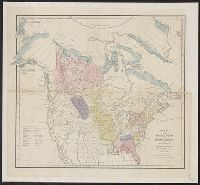
- Creator:
- Gallatin, Albert, 1761-1849
- Published / Created:
- [1836]
- Call Number:
- 71ed 1836
- Container / Volume:
- BRBL_00371
- Image Count:
- 1
- Resource Type:
- Maps, Atlases & Globes
- Subject (Topic):
- Indians of North America--Maps
- Found in:
- Beinecke Rare Book and Manuscript Library > Map of the Indian tribes of North America, about 1600 A.D. along the Atlantic, & about 1800 A.D. westwardly / published by the Amer. Antiq. Soc. from a drawing by Hon. A. Gallatin.
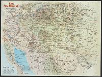
- Creator:
- National Geographic Society (U.S.). Cartographic Division
- Published / Created:
- 1982
- Call Number:
- 7821 1982
- Container / Volume:
- BRBL_00506
- Image Count:
- 2
- Resource Type:
- Maps, Atlases & Globes
- Subject (Topic):
- Indians of North America--Maps
- Found in:
- Beinecke Rare Book and Manuscript Library > The Southwest / produced by the Cartographic Division, National Geographic Society ; John B. Garver, Jr., chief cartographer.
- Published / Created:
- 19--?]
- Call Number:
- 71ED 1850
- Container / Volume:
- BRBL_00371
- Image Count:
- 1
- Resource Type:
- Maps, Atlases & Globes
- Subject (Topic):
- Indians of North America--Maps
- Found in:
- Beinecke Rare Book and Manuscript Library > [Map of Indian tribes of North America].
- Creator:
- Powell, John Wesley, 1834-1902
- Published / Created:
- 1891]
- Call Number:
- 71ef 1890
- Container / Volume:
- BRBL_00371
- Image Count:
- 1
- Resource Type:
- Maps, Atlases & Globes
- Subject (Topic):
- Indians of North America--Maps
- Found in:
- Beinecke Rare Book and Manuscript Library > Linguistic stocks of American Indians north of Mexico / by J.W. Powell.
- Published / Created:
- 1756
- Call Number:
- 755 1756
- Container / Volume:
- BRBL_00428
- Image Count:
- 1
- Resource Type:
- Maps, Atlases & Globes
- Subject (Geographic):
- North America--Maps--Early works to
- Subject (Topic):
- British--North America--Maps--Early
- Found in:
- Beinecke Rare Book and Manuscript Library > Carte des possessions Françoises et Angloises dans le Canada, et partie de la Louisiane / L. Thevenard fil. sculp.
- Creator:
- Palairet, Jean, 1697-1774
- Published / Created:
- 1756
- Call Number:
- 755 1756D
- Container / Volume:
- BRBL_00428
- Image Count:
- 1
- Resource Type:
- Maps, Atlases & Globes
- Subject (Geographic):
- North America--Maps--Early works to
- Subject (Topic):
- British--North America--Maps--Early
- Found in:
- Beinecke Rare Book and Manuscript Library > Carte des possessions angloises & françoises du continent de l'Amérique septentrionale / par I. Palairet, Londres ; Thos. Kitchin, sculpt.
- Published / Created:
- 1756
- Call Number:
- 755 1756A
- Container / Volume:
- BRBL_00428
- Image Count:
- 1
- Resource Type:
- Maps, Atlases & Globes
- Subject (Geographic):
- North America--Maps--Early works to
- Subject (Topic):
- British--North America--Maps--Early
- Found in:
- Beinecke Rare Book and Manuscript Library > Carte du Canada et de la Louisiane qui forment la Nouvelle France et des colonies Angloises ou sont representez les pays contestez ... / par J. B. Nolin ...
- Published / Created:
- [1756?]
- Call Number:
- 755 1756C
- Container / Volume:
- BRBL_00428
- Image Count:
- 1
- Resource Type:
- Maps, Atlases & Globes
- Subject (Geographic):
- North America--Maps--Early works to
- Subject (Topic):
- British--North America--Maps--Early
- Found in:
- Beinecke Rare Book and Manuscript Library > The British & French dominions in North America : particularly shewing the French encroachments through all the British plantations from Nova Scotia down to the Gulf of Mexico.
- Creator:
- Arrowsmith, Aaron, 1750-1823
- Published / Created:
- [1818]
- Call Number:
- 71 1818A
- Container / Volume:
- BRBL_00368
- Image Count:
- 4
- Resource Type:
- Maps, Atlases & Globes
- Subject (Geographic):
- North America--Maps
- Found in:
- Beinecke Rare Book and Manuscript Library > A map exhibiting all the new discoveries in the interior parts of North America : inscribed by permission to the honourable governor and company of adventurers of England trading into Hudsons Bay in testimony of their liberal communications to their most
- Creator:
- L'Isle, Guillaume de, 1675-1726, cartographer.
- Published / Created:
- [1718]
- Call Number:
- BrSides Double Folio 2019 105
- Image Count:
- 1
- Resource Type:
- Maps, Atlases & Globes
- Subject (Geographic):
- North America--Maps.
- Found in:
- Beinecke Rare Book and Manuscript Library > America septentrionalis : concinnata juxta observationes D[omi]n[o] n[ostro] Academiae Regalis Scientiarum et nonnullorum aliorum, et juxta annotationes recentissimas / par G. De L'Isle, geographum.
- Creator:
- Delamarche, Alexandre, 1815-1884, cartographer
- Call Number:
- 71 1838
- Container / Volume:
- BRBL_00370
- Image Count:
- 1
- Resource Type:
- Maps, Atlases & Globes
- Subject (Geographic):
- North America--Maps
- Found in:
- Beinecke Rare Book and Manuscript Library > Carte de l'Amerique Septentrionale / par Delamarche.
- Creator:
- Hennepin, Louis, 17th cent
- Published / Created:
- 19--?]
- Call Number:
- 71 1683
- Container / Volume:
- BRBL_00360
- Image Count:
- 1
- Resource Type:
- Maps, Atlases & Globes
- Subject (Geographic):
- North America--Maps
- Found in:
- Beinecke Rare Book and Manuscript Library > Carte de la Nouvelle France : et de la Louisiane nouvellement decouverte dediee au roy l'an 1683 / par le Reverend Pere Louis Hennepin, missionaire recollect et notaire apostoliquen ; N.Guerard ... et fecit.
- Creator:
- Brué, A. (Adrien Hubert), 1786-1832
- Published / Created:
- [1818]
- Call Number:
- 71 1818
- Container / Volume:
- BRBL_00368
- Image Count:
- 4
- Resource Type:
- Maps, Atlases & Globes
- Subject (Geographic):
- North America--Maps
- Found in:
- Beinecke Rare Book and Manuscript Library > Carte encyprotype de l'Amerique Septentrionale : dediée et preśentée à Monsieur- / par H. Brué, ingénieur-géographe de S.A. Royale ; dirigé par Brue.́
- Creator:
- Dussieux, L. (Louis), 1815-1894, cartographer
- Call Number:
- 70 1865
- Container / Volume:
- BRBL_00359
- Image Count:
- 1
- Resource Type:
- Maps, Atlases & Globes
- Subject (Geographic):
- North America--Maps
- Found in:
- Beinecke Rare Book and Manuscript Library > Carte physique et politique de L'Amerique Septentrionale / par L. Dussieux, 1865.
- Creator:
- Brué, A. (Adrien Hubert), 1786-1832
- Published / Created:
- 1845
- Call Number:
- 71 1845B
- Container / Volume:
- BRBL_00370
- Image Count:
- 1
- Resource Type:
- Maps, Atlases & Globes
- Subject (Geographic):
- North America--Maps
- Found in:
- Beinecke Rare Book and Manuscript Library > Carte physique et politique de l'Amérique Septentrionale / par A.H. Brué, géographe du Roi.
- Creator:
- Brué, A. (Adrien Hubert), 1786-1832
- Published / Created:
- 1821
- Call Number:
- 71 1821
- Container / Volume:
- BRBL_00369
- Image Count:
- 1
- Resource Type:
- Maps, Atlases & Globes
- Subject (Geographic):
- North America--Maps
- Found in:
- Beinecke Rare Book and Manuscript Library > Carte physique et politique de l'Amérique septentrionale / par A.H. Brué, géographe de S.A.R. Monsieur.
- Creator:
- Reichard, C. G. (Christian Gottlieb), 1758-1837
- Published / Created:
- 1813
- Call Number:
- 71 1813
- Container / Volume:
- BRBL_00368
- Image Count:
- 1
- Resource Type:
- Maps, Atlases & Globes
- Subject (Geographic):
- North America--Maps
- Found in:
- Beinecke Rare Book and Manuscript Library > Charte von NordAmerica / entworfen und gezeichnet von C.G. Reichard.
- Creator:
- Reichard, C. G. (Christian Gottlieb), 1758-1837
- Published / Created:
- 1817
- Call Number:
- 71 1817
- Container / Volume:
- BRBL_00368
- Image Count:
- 1
- Resource Type:
- Maps, Atlases & Globes
- Subject (Geographic):
- North America--Maps
- Found in:
- Beinecke Rare Book and Manuscript Library > Charte von NordAmerica / entworfen und gezeichnet von C.G. Reichard.
- Creator:
- Walch, Johannes
- Published / Created:
- 1836
- Call Number:
- 71 1836
- Container / Volume:
- BRBL_00370
- Image Count:
- 1
- Resource Type:
- Maps, Atlases & Globes
- Subject (Geographic):
- North America--Maps
- Found in:
- Beinecke Rare Book and Manuscript Library > Charte von Nordamerica : nach den neuesten Entdeckungen und zuverläfsigsten astronomischen Ortsbestimmungen entworfen / bey Joh: Walch.
- Creator:
- Johnson and Ward
- Published / Created:
- 1866?]
- Call Number:
- 71 1866
- Container / Volume:
- BRBL_00371
- Image Count:
- 2
- Resource Type:
- Maps, Atlases & Globes
- Subject (Geographic):
- North America--Maps
- Found in:
- Beinecke Rare Book and Manuscript Library > Johnson's North America / by Johnson and Ward.
- Creator:
- Smith, J. Calvin (John Calvin)
- Published / Created:
- 1849
- Call Number:
- 71 1849A
- Container / Volume:
- BRBL_00370
- Image Count:
- 1
- Resource Type:
- Maps, Atlases & Globes
- Subject (Geographic):
- North America--Maps
- Found in:
- Beinecke Rare Book and Manuscript Library > Map of North America / by J. Calvin Smith.
- Creator:
- Smith, J. Calvin (John Calvin)
- Published / Created:
- 1850
- Call Number:
- 71 1850A
- Container / Volume:
- BRBL_00370
- Image Count:
- 1
- Resource Type:
- Maps, Atlases & Globes
- Subject (Geographic):
- North America--Maps
- Found in:
- Beinecke Rare Book and Manuscript Library > Map of North America / by J. Calvin Smith.
- Creator:
- Smith, J. Calvin (John Calvin)
- Published / Created:
- 1851
- Call Number:
- 71 1851A
- Container / Volume:
- BRBL_00370
- Image Count:
- 1
- Resource Type:
- Maps, Atlases & Globes
- Subject (Geographic):
- North America--Maps
- Found in:
- Beinecke Rare Book and Manuscript Library > Map of North America / by J. Calvin Smith.
- Creator:
- Wyld, James, 1812-1887
- Published / Created:
- [1854?]
- Call Number:
- 71 1854A
- Container / Volume:
- BRBL_00371
- Image Count:
- 1
- Resource Type:
- Maps, Atlases & Globes
- Subject (Geographic):
- North America--Maps
- Found in:
- Beinecke Rare Book and Manuscript Library > Map of North America : exhibiting the recent discoveries, geographical & nautical / by James Wyld, Geographer to Her Majesty ; J.W. del. ; Stockley fc.
- Creator:
- Wyld, James, 1812-1887
- Published / Created:
- [1828]
- Call Number:
- 71 1828
- Container / Volume:
- BRBL_00369
- Image Count:
- 7
- Resource Type:
- Maps, Atlases & Globes
- Subject (Geographic):
- North America--Maps
- Found in:
- Beinecke Rare Book and Manuscript Library > Map of North America : exhibiting the recent discoveries, geographical and nautical; drawn chiefly from the authorities of M. de Humbolt, Lieutt. Pike, Messrs. Lewis and Clarke, Sir Alexr. Mackenzie, Mr. Hearne, Coll. Bouchette, Captns. Vancouver, Ross, P
- Creator:
- Wyld, James, 1812-1887
- Published / Created:
- [187-?]
- Call Number:
- 71 1870A
- Container / Volume:
- BRBL_00371
- Image Count:
- 1
- Resource Type:
- Maps, Atlases & Globes
- Subject (Geographic):
- North America--Maps
- Found in:
- Beinecke Rare Book and Manuscript Library > Map of North America : exhibiting the recent discoveries, geographical and nautical; drawn chiefly from the authorities of M. de Humbolt, Lieutt. Pike, Messrs. Lewis and Clarke, Sir Alexr. Mackenzie, Mr. Hearne, Coll. Bouchette, Captns. Vancouver, Ross, P
- Creator:
- Geological Survey (U.S.)
- Published / Created:
- 1912
- Call Number:
- 71 1912
- Container / Volume:
- BRBL_00371
- Image Count:
- 1
- Resource Type:
- Maps, Atlases & Globes
- Subject (Geographic):
- North America--Maps
- Found in:
- Beinecke Rare Book and Manuscript Library > Map of North America : reduced from map on scale of 1:5,000,000 / compiled by the U.S. Geological Survey.
- Creator:
- National Railway Publication Company
- Call Number:
- BrSides Zc19 N82h 870na
- Image Count:
- 1
- Resource Type:
- Maps, Atlases & Globes
- Subject (Geographic):
- North America--Maps.
- Found in:
- Beinecke Rare Book and Manuscript Library > Map of the Northern Pacific Railway and tributary country.
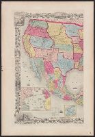
- Creator:
- Colton, G. Woolworth (George Woolworth), 1827-1901
- Published / Created:
- 1854
- Call Number:
- 71 1854B
- Container / Volume:
- BRBL_00371
- Image Count:
- 2
- Resource Type:
- Maps, Atlases & Globes
- Subject (Geographic):
- North America--Maps
- Found in:
- Beinecke Rare Book and Manuscript Library > Map of the United States of America, the British provinces, Mexico, the West Indies, and Central America, with part of New Granada and Venezuela / map drawn by Geo. W. Colton ; engraved by John M. Atwood ; border desig'd. & eng'd. by W.S. Barnard.
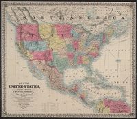
- Creator:
- Atwood, John M., b. ca. 1818
- Published / Created:
- 1851
- Call Number:
- 75 1851B
- Container / Volume:
- BRBL_00400
- Image Count:
- 1
- Resource Type:
- Maps, Atlases & Globes
- Subject (Geographic):
- North America--Maps
- Found in:
- Beinecke Rare Book and Manuscript Library > Map of the United States, Canada, Mexico, Central America, and the West India Islands : with a portion of Venezuela & New Granada; showing the routes overland and by the Isthmus to California & Oregon, also the new boundaries of California, Utah, & New Me
- Creator:
- Stieler, Adolf, 1775-1836
- Published / Created:
- 1835?]
- Call Number:
- 71 1835
- Container / Volume:
- BRBL_00370
- Image Count:
- 1
- Resource Type:
- Maps, Atlases & Globes
- Subject (Geographic):
- North America--Maps
- Found in:
- Beinecke Rare Book and Manuscript Library > Nord America / entworfen u. gezeichnet von F. v. St. 1832 ; L. Thiel sc.
- Creator:
- Weiland, C. F. (Carl Ferdinand), -1847, cartographer
- Published / Created:
- 1833
- Call Number:
- 71 1833
- Container / Volume:
- BRBL_00369
- Image Count:
- 1
- Resource Type:
- Maps, Atlases & Globes
- Subject (Geographic):
- North America--Maps
- Found in:
- Beinecke Rare Book and Manuscript Library > Nord America / entworfen und gezeichnet von C.F. Weiland ; Gest. v. C. Jungmann, W. 30.
- Creator:
- Wilkinson, Robert, -approximately 1825
- Published / Created:
- 1823 August 12
- Call Number:
- 71 1823
- Container / Volume:
- BRBL_00369
- Image Count:
- 1
- Resource Type:
- Maps, Atlases & Globes
- Subject (Geographic):
- North America--Maps
- Found in:
- Beinecke Rare Book and Manuscript Library > North America / E. Bourne sculp.
- Creator:
- Thomson, John, geographer
- Published / Created:
- 1814
- Call Number:
- 71 1814
- Container / Volume:
- BRBL_00368
- Image Count:
- 1
- Resource Type:
- Maps, Atlases & Globes
- Subject (Geographic):
- North America--Maps
- Found in:
- Beinecke Rare Book and Manuscript Library > North America / N.R. Hewitt, sc.
- Creator:
- Betts, John, fl. 1844-1863
- Published / Created:
- [18--?]
- Call Number:
- 71 18XX
- Container / Volume:
- BRBL_00371
- Image Count:
- 2
- Resource Type:
- Maps, Atlases & Globes
- Subject (Geographic):
- North America--Maps
- Found in:
- Beinecke Rare Book and Manuscript Library > North America.
- Creator:
- Vuillemin, A. (Alexandre), 1812-
- Published / Created:
- [1855?]
- Call Number:
- 71 1855C
- Container / Volume:
- BRBL_00371
- Image Count:
- 1
- Resource Type:
- Maps, Atlases & Globes
- Subject (Geographic):
- North America--Maps
- Found in:
- Beinecke Rare Book and Manuscript Library > Nouvelle carte illustrée de l'Amérique du nord : indiquant les grandes divisions physiques, la distribution géographique des végétaux et des minéraux, les ports de commerce, villes industrielles en fortifiées / dressée par A. Vuillemin, géographe
- Creator:
- Platt, Albert, 1794-1862
- Published / Created:
- 184-?]
- Call Number:
- 71CB 1840A
- Container / Volume:
- BRBL_00371
- Image Count:
- 1
- Resource Type:
- Maps, Atlases & Globes
- Subject (Geographic):
- North America--Maps
- Found in:
- Beinecke Rare Book and Manuscript Library > Oro-und hydrographische Karte v. Nordamerica.
- Creator:
- Wyld, James, 1812-1887
- Published / Created:
- March 2nd 1857.
- Call Number:
- 71 1857
- Container / Volume:
- BRBL_00371
- Image Count:
- 2
- Resource Type:
- Maps, Atlases & Globes
- Subject (Geographic):
- North America--Maps
- Found in:
- Beinecke Rare Book and Manuscript Library > The British possessions in North America and the United States with the Hudson's Bay territories / by James Wyld, geographer to the Queen & H.R.H. Prince Albert.
- Creator:
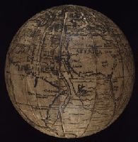
- Holbein, Hans, 1497-1543. Ambassadors
Schöner, Johann, 1477-1547
- Published / Created:
- ca. 1885?]
- Call Number:
- 2003 1481
- Image Count:
- 9
- Resource Type:
- Maps, Atlases & Globes
- Subject (Geographic):
- North America--Maps
- Found in:
- Beinecke Rare Book and Manuscript Library > ["The Ambassadors" globe]
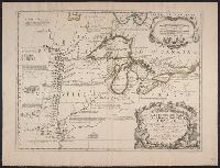
- Creator:
- Coronelli, Vincenzo, 1650-1718
- Published / Created:
- 1688
- Call Number:
- 755 1688
- Container / Volume:
- BRBL_00424
- Image Count:
- 1
- Resource Type:
- Maps, Atlases & Globes
- Subject (Geographic):
- Great Lakes Region (North America
- Subject (Topic):
- Indians of North America--Maps--Early
- Found in:
- Beinecke Rare Book and Manuscript Library > Partie occidentale du Canada, ou de la Nouvelle France : ou sont les nations des Ilinois, de Tracy, les Iroquois, et plusieurs autres peuples; avec la Louisiane nouvellement decouverte etc. Dressée sur les memoires les plus nouveaux / par le P. Coronelli
- Creator:
- Kitchin, Thomas, d. 1784
- Published / Created:
- 1766?]
- Call Number:
- 755 1763A
- Container / Volume:
- BRBL_00428
- Image Count:
- 1
- Resource Type:
- Maps, Atlases & Globes
- Subject (Geographic):
- North America--Maps--Early works to
- Subject (Topic):
- British--North America--Maps--Early
- Found in:
- Beinecke Rare Book and Manuscript Library > A new and accurate map of the British dominions in America, according to the Treaty of 1763, divided into the several provinces and jurisdictions : projected upon the best authorities and astronomical observations / by Thos. Kitchin, geographer.
- Creator:
- Hendges, M
- Published / Created:
- 1904
- Call Number:
- 70gme 1904
- Container / Volume:
- BRBL_00359
- Image Count:
- 1
- Resource Type:
- Maps, Atlases & Globes
- Subject (Topic):
- Railroads--North America--Maps
- Found in:
- Beinecke Rare Book and Manuscript Library > Intercontinental railway map : prepared under the direction of the permanent Pan American Railway Committee authorized by the Second International Conference of American States / M. Hendges.
- Creator:
- Steiger, W. T
- Published / Created:
- 1854
- Call Number:
- 75gme 1854
- Container / Volume:
- BRBL_00411
- Image Count:
- 2
- Resource Type:
- Maps, Atlases & Globes
- Subject (Topic):
- Railroads--North America--Maps
- Found in:
- Beinecke Rare Book and Manuscript Library > Diagram of the United States of America, Mexico, the West India Islands and Isthmus of Darien : showing proposed routes of the Pacific Rail Road ... / by W. T. Steiger, General Land Office ; Lith. by A. Hoen & Co. Baltimore.
- Creator:
- Kitchin, Thomas, d. 1784
- Published / Created:
- 1780?]
- Call Number:
- 755 1760
- Container / Volume:
- BRBL_00428
- Image Count:
- 1
- Resource Type:
- Maps, Atlases & Globes
- Subject (Geographic):
- North America--Maps--Early works to
- Subject (Topic):
- Indians of North America--Maps--Early
- Found in:
- Beinecke Rare Book and Manuscript Library > British dominions in America : drawn from the latest and best authorities / by Thos. Kitchin, hydrographer to his majesty.
- Creator:
- Gibson, J. (John)
- Published / Created:
- 1763]
- Call Number:
- 75 1778
- Collection Title:
- Gentleman's magazine.
- Container / Volume:
- BRBL_00689
- Image Count:
- 1
- Resource Type:
- Maps, Atlases & Globes
- Subject (Geographic):
- North America--Maps--Early works to
- Subject (Topic):
- Indians of North America--Maps--Early
- Found in:
- Beinecke Rare Book and Manuscript Library > [Map of Louisiana and the western parts of Virginia and Carolina] / [cartographic material] / J. Gibson, sculp.
- Creator:
- G.W. & C.B. Colton & Co
- Published / Created:
- 1870
- Call Number:
- 80 1870
- Container / Volume:
- BRBL_00535
- Image Count:
- 1
- Resource Type:
- Maps, Atlases & Globes
- Subject (Topic):
- Indians of North America--Maps
- Found in:
- Beinecke Rare Book and Manuscript Library > Colton's map of the states and territories west of the Mississippi River to the Pacific Ocean : showing the overland routes, projected rail road lines, &c.
- Creator:
- G.W. & C.B. Colton & Co
- Published / Created:
- 1870
- Call Number:
- 80 1881
- Container / Volume:
- BRBL_00536
- Image Count:
- 1
- Resource Type:
- Maps, Atlases & Globes
- Subject (Topic):
- Indians of North America--Maps
- Found in:
- Beinecke Rare Book and Manuscript Library > Colton's map of the states and territories west of the Mississippi River to the Pacific Ocean : showing the overland routes, projected rail road lines, &c.
- Creator:
- United States. Office of Indian Affairs
- Published / Created:
- 1909
- Call Number:
- 75ed 1909
- Container / Volume:
- BRBL_00410
- Image Count:
- 1
- Resource Type:
- Maps, Atlases & Globes
- Subject (Topic):
- Indians of North America--Maps
- Found in:
- Beinecke Rare Book and Manuscript Library > Map showing Indian reservations within the limits of the United States, 1909 / [Department of the Interior, Office of Indian Affairs] ; compiled under the direction of R. G. Valentine.
- Published / Created:
- 1683?]
- Call Number:
- 807 1683
- Container / Volume:
- BRBL_00717
- Image Count:
- 2
- Resource Type:
- Maps, Atlases & Globes
- Subject (Topic):
- Indians of North America--Maps
- Found in:
- Beinecke Rare Book and Manuscript Library > [An untitled manuscript map in French depicting the Mississippi River valley from the Gulf of Mexico to the Illinois River in the north and tracing the Wabash and Ohio Rivers in the northeast .]
- Creator:
- Arrowsmith, Aaron, 1750-1823, cartographer.
- Call Number:
- 71 1811
- Image Count:
- 4
- Resource Type:
- Maps, Atlases & Globes
- Subject (Geographic):
- North America--Maps.
- Found in:
- Beinecke Rare Book and Manuscript Library > A map exhibiting all the new discoveries in the interior parts of North America [cartographic material] / inscribed by permission to the honorable governor and company of the adventurers of England trading into Hudsons Bay, in testimony of their liberal communications to their most obedient and very humble servant A. Arrowsmith, hydrographer to H.R.H. the Prince of Wales, January 1st 1795 ; Puke, sc.
- Creator:
- U.S. Lake Survey
- Published / Created:
- 1885
- Call Number:
- 8075cea 1885
- Container / Volume:
- BRBL_00551
- Image Count:
- 1
- Resource Type:
- Maps, Atlases & Globes
- Subject (Geographic):
- Great Lakes (North America)--Maps.
- Found in:
- Beinecke Rare Book and Manuscript Library > Index chart of the northern and northwestern lakes : compiled from the data of the U.S. Survey and showing the names and limits of the published charts / compiled and drawn by Edward Molitor.
- Published / Created:
- 1852
- Call Number:
- 8075gme 1852
- Container / Volume:
- BRBL_00551
- Image Count:
- 1
- Resource Type:
- Maps, Atlases & Globes
- Subject (Geographic):
- Great Lakes (North America)--Maps
- Found in:
- Beinecke Rare Book and Manuscript Library > Map showing the several lines of R.R. : leading from the Lakes to the MIssissippi River together with the route surveyed by the St. C. & L.S. R.R. Co.
- Creator:
- Brué, Adrien Hubert, 1786-1832
- Published / Created:
- 1835
- Call Number:
- 71 1835B
- Container / Volume:
- BRBL_00370
- Image Count:
- 4
- Resource Type:
- Maps, Atlases & Globes
- Subject (Geographic):
- North America--Maps
- Found in:
- Beinecke Rare Book and Manuscript Library > Nouvelle carte de l'Amérique septentrionale, du Groënland et des îles qui en dépendent / par A.H. Brué, géographe du Roi ... ; Artus et Massuet, sculpt.
- Creator:
- Rand McNally and Company
- Published / Created:
- c1914.
- Call Number:
- 88hc 1914
- Container / Volume:
- BRBL_00649
- Image Count:
- 2
- Resource Type:
- Maps, Atlases & Globes
- Alternative Title:
- New commercial atlas map of North
- Description:
- North America" (scale [1:20,592,000]) on
- Subject (Geographic):
- North America--Maps
- Found in:
- Beinecke Rare Book and Manuscript Library > The Rand McNally new commercial atlas map of Mexico.
- Published / Created:
- 1849
- Call Number:
- 844cea 1849
- Container / Volume:
- BRBL_00613
- Image Count:
- 1
- Resource Type:
- Maps, Atlases & Globes
- Subject (Geographic):
- Pacific Coast (North America)--Maps
- Found in:
- Beinecke Rare Book and Manuscript Library > The coasts of California, Oregon, &c.
- Published / Created:
- 1850
- Call Number:
- 754gme 1850
- Container / Volume:
- BRBL_00419
- Image Count:
- 1
- Resource Type:
- Maps, Atlases & Globes
- Subject (Geographic):
- Great Lakes (North America)--Maps
- Found in:
- Beinecke Rare Book and Manuscript Library > [Railroads of the Lake States, from Great Lakes to Ohio River]
- Creator:
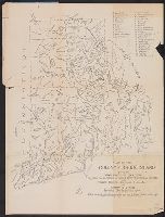
- Rider, Sidney S. (Sidney Smith), 1833-1917
- Published / Created:
- 1903
- Call Number:
- 765 1904
- Container / Volume:
- BRBL_00463
- Image Count:
- 1
- Resource Type:
- Maps, Atlases & Globes
- Subject (Topic):
- Names, Indian--North America--Maps
- Found in:
- Beinecke Rare Book and Manuscript Library > Map of the Colony of Rhode Island : giving the Indian names of locations and the locations of great events in Indian history with present political divisions indicated / by Sidney S. Rider.
- Creator:
- United States. Bureau of Indian Affairs
- Published / Created:
- 1907
- Call Number:
- 75ea 1907A
- Container / Volume:
- BRBL_00409
- Image Count:
- 1
- Resource Type:
- Maps, Atlases & Globes
- Subject (Topic):
- Indian reservations--North America
- Found in:
- Beinecke Rare Book and Manuscript Library > Map showing Indian reservations within the limits of the United States / compiled under the direction of the Hon. F.E. Leupp, Commissioner of Indian Affairs.
- Creator:
- United States. Bureau of Indian Affairs
- Published / Created:
- 1904
- Call Number:
- 75ed 1904
- Container / Volume:
- BRBL_00410
- Image Count:
- 1
- Resource Type:
- Maps, Atlases & Globes
- Subject (Topic):
- Indian reservations--North America
- Found in:
- Beinecke Rare Book and Manuscript Library > Map showing Indian reservations within the limits of the United States / compiled under the direction of the Hon. W.A. Jones, Commissioner of Indian Affairs.
- Creator:
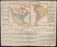
- Tanner, Henry Schenck, 1786-1858
- Published / Created:
- [1822 or 1823]
- Call Number:
- 71 1822
- Container / Volume:
- BRBL_00369
- Image Count:
- 4
- Resource Type:
- Maps, Atlases & Globes
- Subject (Geographic):
- North America--Maps
- Found in:
- Beinecke Rare Book and Manuscript Library > A map of North America : constructed according to the latest information / engraved & published by H.S. Tanner, Philadelphia 1822.
- Creator:
- Reichard, C. G. (Christian Gottlieb), 1758-1837
- Published / Created:
- 1802
- Call Number:
- 71 1802B
- Container / Volume:
- BRBL_00367
- Image Count:
- 1
- Resource Type:
- Maps, Atlases & Globes
- Subject (Geographic):
- North America--Maps
- Found in:
- Beinecke Rare Book and Manuscript Library > Charte von Nordamerica : nach den neuesten Bestimmungen und Entdeckungen / von C.G. Reichard.
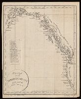
- Published / Created:
- [1814?]
- Call Number:
- BrSides 2018 138
- Image Count:
- 1
- Resource Type:
- Maps, Atlases & Globes
- Subject (Geographic):
- Northwest Coast of North America--Maps.
- Found in:
- Beinecke Rare Book and Manuscript Library > Charte von der nordwestküste America's nach Vancouver.
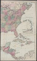
- Creator:
- G.W. & C.B. Colton & Co
- Published / Created:
- 1869
- Call Number:
- 75 1869A
- Container / Volume:
- BRBL_00404
- Image Count:
- 2
- Resource Type:
- Maps, Atlases & Globes
- Subject (Geographic):
- North America--Maps
- Found in:
- Beinecke Rare Book and Manuscript Library > Colton's map of the United States of America, the British provinces, Mexico and the West Indies : showing the country from the Atlantic to the Pacific Ocean.
- Creator:
- Carey, Henry Charles, 1793-1879
- Published / Created:
- 1822]
- Call Number:
- 70 1822C
- Container / Volume:
- BRBL_00358
- Image Count:
- 1
- Resource Type:
- Maps, Atlases & Globes
- Subject (Geographic):
- North America--Maps
- Found in:
- Beinecke Rare Book and Manuscript Library > Geographical, statistical and historical map of America / Young & Delleker sc.
- Creator:
- Coronelli, Vincenzo, 1650-1718
- Published / Created:
- 19--?]
- Call Number:
- 71 1680A
- Container / Volume:
- BRBL_00360
- Image Count:
- 1
- Resource Type:
- Maps, Atlases & Globes
- Subject (Geographic):
- Great Lakes Region (North America
- Found in:
- Beinecke Rare Book and Manuscript Library > La Louisiana, parte settentrionalle : scoperta sotta la protettione di Luigi XIV, Ré di Francia, etc. / descritta, e dedicata, dal P. Cosmografo Coronelli.
- Creator:
- Rosa, R
- Published / Created:
- 1868, c1864.
- Call Number:
- 75 1868B
- Container / Volume:
- BRBL_00404
- Image Count:
- 2
- Resource Type:
- Maps, Atlases & Globes
- Subject (Geographic):
- North America--Maps
- Found in:
- Beinecke Rare Book and Manuscript Library > The American continent : topographical and railroad map of the United States, British possessions, West Indies, Mexico, and Central America / compiled from the best authorities by R. Rosa, late Col. 46th Regiment N.Y.V. ; Haasis & Lubrecht, publishers, Li
- Creator:
- Middleton, Strobridge & Co
- Published / Created:
- [1857].
- Call Number:
- 753gme 1858
- Container / Volume:
- BRBL_00415
- Image Count:
- 1
- Resource Type:
- Maps, Atlases & Globes
- Subject (Geographic):
- Great Lakes (North America)--Maps
- Subject (Topic):
- Railroads--Great Lakes (North America
- Found in:
- Beinecke Rare Book and Manuscript Library > Map illustrating the Canada Pacific and Northern Pacific and other proposed Railroads, connecting at Straits of Mackinaw : Also showing the position of Mackinaw City.
- Creator:
- Scoles, John, 1772?-1853
- Published / Created:
- [1796?]
- Call Number:
- 71 1795
- Container / Volume:
- BRBL_00367
- Image Count:
- 1
- Resource Type:
- Maps, Atlases & Globes
- Subject (Geographic):
- North America--Maps--Early works to
- Found in:
- Beinecke Rare Book and Manuscript Library > A general map of North America : drawn from the best surveys, 1795 / Scoles sc.
- Creator:
- Lodge, John, -1796
- Published / Created:
- [1778?]
- Call Number:
- BrSides 2017 62
- Image Count:
- 1
- Resource Type:
- Maps, Atlases & Globes
- Subject (Geographic):
- North America--Maps--Early works to
- Found in:
- Beinecke Rare Book and Manuscript Library > A general map of North America ; from the latest observations / engrav'd by Jno. Lodge from the late Mr. Jefferys, geographer to the King.
- Creator:
- Delarochette, L. (Louis), 1731-1802
- Published / Created:
- 1765
- Call Number:
- 71 1765
- Container / Volume:
- BRBL_00364
- Image Count:
- 1
- Resource Type:
- Maps, Atlases & Globes
- Subject (Geographic):
- North America--Maps--Early works to
- Found in:
- Beinecke Rare Book and Manuscript Library > A map of North America / by J. Palairet, with considerable alterations & improvements from d'Anville, Mitchell & Bellin, by L. Delarochette.
- Creator:
- Anville, Jean Baptiste Bourguignon d', 1697-1782
- Published / Created:
- 17--?]
- Call Number:
- 71 1769A
- Container / Volume:
- BRBL_00364
- Image Count:
- 1
- Resource Type:
- Maps, Atlases & Globes
- Subject (Geographic):
- North America--Maps--Early works to
- Found in:
- Beinecke Rare Book and Manuscript Library > A map of North America : from D'Anville, 1769.
- Creator:
- Harrison, John, fl. 1784-1792
- Published / Created:
- 1791?]
- Call Number:
- 71 1791
- Container / Volume:
- BRBL_00367
- Image Count:
- 1
- Resource Type:
- Maps, Atlases & Globes
- Subject (Geographic):
- North America--Maps--Early works to
- Found in:
- Beinecke Rare Book and Manuscript Library > A map of North America : published under the patronage of the Duke of Orleans by d'Anville / drawn and engraved for J. Harrison, No. 115 Newgate Street, January 1, 1791.
- Creator:
- Seale, Richard William
- Published / Created:
- 1745?]
- Call Number:
- 71 1746
- Container / Volume:
- BRBL_00362
- Image Count:
- 1
- Resource Type:
- Maps, Atlases & Globes
- Subject (Geographic):
- North America--Maps--Early works to
- Found in:
- Beinecke Rare Book and Manuscript Library > A map of North America : with the European settlements & whatever else is remarkable in ye West Indies, from the latest and best observations / R.W. Seale, delin. et sculp.
- Creator:
- Delarochette, L. (Louis), 1731-1802
- Published / Created:
- 1st of March 1789.
- Call Number:
- 71 1789
- Container / Volume:
- BRBL_00366
- Image Count:
- 4
- Resource Type:
- Maps, Atlases & Globes
- Subject (Geographic):
- North America--Maps--Early works to
- Found in:
- Beinecke Rare Book and Manuscript Library > A map of North America and the West Indies / by L.S. de la Rochette.
- Creator:
- Blair, John, d. 1782
- Published / Created:
- 176-?]
- Call Number:
- 71 1760B
- Container / Volume:
- BRBL_00364
- Image Count:
- 1
- Resource Type:
- Maps, Atlases & Globes
- Subject (Geographic):
- North America--Maps--Early works to
- Found in:
- Beinecke Rare Book and Manuscript Library > A map of North America, from the latest surveys and maps / by John Blair as a supplement to his Tables of chronology ; Thos. Kitchin, sculpsit.
- Creator:
- Popple, Henry, -1743
- Published / Created:
- [ca. 1741]
- Call Number:
- 755 1734A
- Container / Volume:
- BRBL_00426
- Image Count:
- 1
- Resource Type:
- Maps, Atlases & Globes
- Subject (Geographic):
- North America--Maps--Early works to
- Found in:
- Beinecke Rare Book and Manuscript Library > A map of the British Empire in America, with the French, Spanish and Hollandish settlements adjacent thereto / by Henry Popple.
- Creator:
- Popple, Henry, -1743
- Published / Created:
- [ca. 1741]
- Call Number:
- 71 1741
- Container / Volume:
- BRBL_00687
- Image Count:
- 1
- Resource Type:
- Maps, Atlases & Globes
- Subject (Geographic):
- North America--Maps--Early works to
- Found in:
- Beinecke Rare Book and Manuscript Library > A map of the British Empire in America, with the French, Spanish and Hollandish settlements adjacent thereto / by Henry Popple.
- Creator:
- Popple, Henry, -1743
- Published / Created:
- [ca. 1741]
- Call Number:
- 85 1760A
- Container / Volume:
- BRBL_00693
- Image Count:
- 1
- Resource Type:
- Maps, Atlases & Globes
- Subject (Geographic):
- North America--Maps--Early works to
- Found in:
- Beinecke Rare Book and Manuscript Library > A map of the British Empire in America, with the French, Spanish and Hollandish settlements adjacent thereto / by Henry Popple.
- Creator:
- Popple, Henry, -1743
- Published / Created:
- [ca. 1741]
- Call Number:
- 89 1733
- Container / Volume:
- BRBL_00697
- Image Count:
- 1
- Resource Type:
- Maps, Atlases & Globes
- Subject (Geographic):
- North America--Maps--Early works to
- Found in:
- Beinecke Rare Book and Manuscript Library > A map of the British Empire in America, with the French, Spanish and Hollandish settlements adjacent thereto / by Henry Popple.
- Creator:
- Popple, Henry, -1743
- Published / Created:
- [ca. 1741]
- Call Number:
- 85 1734
- Container / Volume:
- BRBL_00636
- Image Count:
- 1
- Resource Type:
- Maps, Atlases & Globes
- Subject (Geographic):
- North America--Maps--Early works to
- Found in:
- Beinecke Rare Book and Manuscript Library > A map of the British Empire in America, with the French, Spanish and Hollandish settlements adjacent thereto / by Henry Popple.
- Creator:
- Popple, Henry, -1743
- Published / Created:
- [ca. 1741]
- Call Number:
- 755 1734B
- Container / Volume:
- BRBL_00426
- Image Count:
- 1
- Resource Type:
- Maps, Atlases & Globes
- Subject (Geographic):
- North America--Maps--Early works to
- Found in:
- Beinecke Rare Book and Manuscript Library > A map of the British Empire in America, with the French, Spanish and Hollandish settlements adjacent thereto / by Henry Popple.
- Creator:
- Dunn, Samuel, d. 1794
- Call Number:
- 71 1776
- Container / Volume:
- BRBL_00687
- Image Count:
- 1
- Resource Type:
- Maps, Atlases & Globes
- Subject (Geographic):
- North America--Maps--Early works to
- Found in:
- Beinecke Rare Book and Manuscript Library > A map of the British Empire, in North America / by Samuel Dunn, mathematician, improved from the surveys of Capt. Carver.
- Creator:
- Mitchell, John, 1711-1768
- Published / Created:
- [1757]
- Call Number:
- BrSides Double Folio 2019 82
- Image Count:
- 4
- Resource Type:
- Maps, Atlases & Globes
- Subject (Geographic):
- North America--Maps--Early works to
- Found in:
- Beinecke Rare Book and Manuscript Library > A map of the British and French dominions in North America : with the roads, distances, limits, and extent of the settlements / by Jno. Mitchell, D.F. with improvements.
- Creator:
- Mitchell, John, 1711-1768
- Published / Created:
- [1755]
- Call Number:
- 71 1755D
- Container / Volume:
- BRBL_00363
- Image Count:
- 8
- Resource Type:
- Maps, Atlases & Globes
- Subject (Geographic):
- North America--Maps--Early works to
- Found in:
- Beinecke Rare Book and Manuscript Library > A map of the British and French dominions in North America : with the roads, distances, limits, and extent of the settlements, humbly inscribed to the Right Honourable the Earl of Halifax, and the other Right Honourable the Lords Commissioners for Trade &
- Creator:
- Mitchell, John, 1711-1768
- Published / Created:
- [1773]
- Call Number:
- 71 1773
- Container / Volume:
- BRBL_00365
- Image Count:
- 4
- Resource Type:
- Maps, Atlases & Globes
- Subject (Geographic):
- North America--Maps--Early works to
- Found in:
- Beinecke Rare Book and Manuscript Library > A map of the British and French dominions in North America : with the roads, distances, limits, and extent of the settlements, humbly inscribed to the Right Honourable the Earl of Halifax, and the other Right Honourable the Lords Commissioners for Trade &
- Creator:
- Mitchell, John, 1711-1768
- Published / Created:
- [1775?]
- Call Number:
- 71 1755A
- Container / Volume:
- BRBL_00363
- Image Count:
- 8
- Resource Type:
- Maps, Atlases & Globes
- Subject (Geographic):
- North America--Maps--Early works to
- Found in:
- Beinecke Rare Book and Manuscript Library > A map of the British colonies in North America : with the roads, distances, limits, and extent of the settlements, humbly inscribed to the Right Honourable the Earl of Halifax, and the other Right Honourable the Lords Commissioners for Trade & Plantations
- Published / Created:
- 1776
- Call Number:
- 71 1776M
- Container / Volume:
- BRBL_00726
- Image Count:
- 1
- Resource Type:
- Maps, Atlases & Globes
- Subject (Geographic):
- North America--Maps--Early works to
- Found in:
- Beinecke Rare Book and Manuscript Library > A map of the British empire in North America / by Samuel Dunn, mathematician ; improved from the surveys of Capt. Carver.
- Published / Created:
- 1774
- Call Number:
- 71 1774
- Container / Volume:
- BRBL_00726
- Image Count:
- 1
- Resource Type:
- Maps, Atlases & Globes
- Subject (Geographic):
- North America--Maps--Early works to
- Found in:
- Beinecke Rare Book and Manuscript Library > A map of the British empire in North America / by Samuel Dunn, mathematician.
- Creator:
- Herbert, William, 1718-1795
- Published / Created:
- 1755
- Call Number:
- 755 1755W
- Container / Volume:
- BRBL_00427
- Image Count:
- 1
- Resource Type:
- Maps, Atlases & Globes
- Subject (Geographic):
- North America--Maps--Early works to
- Found in:
- Beinecke Rare Book and Manuscript Library > A new and accurate map of the English empire in North America : representing their rightful claim as confirm'd by charters, and the formal surrender of their Indian friends; likewise the encroachments of the French, with the several forts they have unjust
- Creator:
- Lotter, Matthäus Albrecht, 1741-1810
- Published / Created:
- 1784
- Call Number:
- 71 1784L
- Container / Volume:
- BRBL_00726
- Image Count:
- 4
- Resource Type:
- Maps, Atlases & Globes
- Subject (Geographic):
- North America--Maps--Early works to
- Found in:
- Beinecke Rare Book and Manuscript Library > A new and correct map of North America with the West India Islands : divided according to the last Treaty of Peace, concluded at Paris the 20th of Jan. 1783, wherein are particularly distinguished the Thirteen Provinces wich [sic] compose the United State
- Creator:
- Pownall, Thomas, 1722-1805
- Published / Created:
- 1777
- Call Number:
- 71 1777B
- Container / Volume:
- BRBL_00365
- Image Count:
- 1
- Resource Type:
- Maps, Atlases & Globes
- Subject (Geographic):
- North America--Maps--Early works to
- Found in:
- Beinecke Rare Book and Manuscript Library > A new and correct map of North America, with the West India Islands : divided according to the last treaty of peace, concluded at Paris. 10th. Feby. 1763, wherein are particularly distinguished, the several provinces and colonies, which compose the Britis
- Creator:
- Pownall, Thomas, 1722-1805
- Published / Created:
- [1783?]
- Call Number:
- 71 1783B
- Container / Volume:
- BRBL_00366
- Image Count:
- 2
- Resource Type:
- Maps, Atlases & Globes
- Subject (Geographic):
- North America--Maps--Early works to
- Found in:
- Beinecke Rare Book and Manuscript Library > A new and correct map of North America, with the West India Islands : divided according to the preliminary articles of peace, concluded at Versailles, 20 Jan. 1783, wherein are particularly distinguished, the United States & the several provinces and colo
- Creator:
- Sayer, Robert, 1725-1794
- Published / Created:
- [between 1750 and 1769?]
- Call Number:
- 71 1760C
- Container / Volume:
- BRBL_00364
- Image Count:
- 1
- Resource Type:
- Maps, Atlases & Globes
- Subject (Geographic):
- North America--Maps--Early works to
- Found in:
- Beinecke Rare Book and Manuscript Library > A new map of North America : with the British, French, Spanish, Dutch & Danish dominions on that great continent; and the West India Islands / done from the latest geographers, with great improvements from the Sieurs d'Anville & Robert.
- Creator:
- Pownall, Thomas, 1722-1805
- Published / Created:
- 1794 May 12
- Call Number:
- 71 1794
- Container / Volume:
- BRBL_00367
- Image Count:
- 2
- Resource Type:
- Maps, Atlases & Globes
- Subject (Geographic):
- North America--Maps--Early works to
- Found in:
- Beinecke Rare Book and Manuscript Library > A new map of North America with the West India Islands : divided according to the preliminary articles of peace, signed at Versailles, 20 Jan. 1783, wherein are particularly distinguished the United States, and the several provinces, governments &ca which
- Creator:
- Pownall, Thomas, 1722-1805
- Published / Created:
- 12th May 1794.
- Call Number:
- 71 1794P
- Container / Volume:
- BRBL_00726
- Image Count:
- 2
- Resource Type:
- Maps, Atlases & Globes
- Subject (Geographic):
- North America--Maps--Early works to
- Found in:
- Beinecke Rare Book and Manuscript Library > A new map of North America with the West India Islands : divided according to the preliminary articles of peace, signed at Versailles, 20 Jan. 1783, wherein are particularly distinguished the United States, and the several provinces, governments &ca which