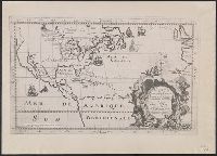
Photocopy of map from Hennepin's Description de la Louisiane. Paris, 1683. and Relief shown pictorially.
Publisher:
s.n.,
Subject (Geographic):
NorthAmerica--Maps
Subject (Name):
Guérard, Nicholas and Hennepin, Louis, 17th cent. Description de la Louisiane, nouvellement decouverte au sud' oüest de la Nouvelle France, par ordre du roy
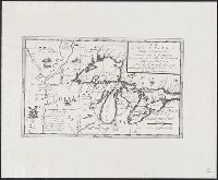
Anglo-American peace negotiations of 1782., Geological Survey bulletin ; 817., Hints of an acceptable minimum boundary., Map illustr, and Map illustrating compromise boundaries between Spanish dominions and the United States as proposed by French diplomacy, 1782.
Description:
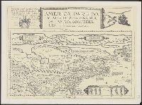
Map illustrating Spanish territorial demands in 1782 -- Map illustrating compromise boundaries between Spanish dominions and the United States as proposed by French diplomacy, 1782 -- The Anglo-American peace negotiations of 1782 and Relief shown pictorially.
Publisher:
U.S. Geological Survey?,
Subject (Geographic):
NorthAmerica--Maps--Early works to
Subject (Name):
Great Britain.--Treaties, etc.--United States,--1783 Sept. 3--Maps--Early works to 1800--Facsimiles, Jefferys and Faden, London, and Mitchell, John, 1711-1768. Map of the British and French dominions in North America
Subject (Topic):
British--America--Maps--Early works to 1800--Facsimiles and Maps--Early works to 1800--Facsimiles