Skip to search
Skip to main content
Skip to first result
Search
You Searched For
Date
1761 - 1761
Resource Type
Maps, Atlases & Globes
Date Created
1761
New Search
Search Results
Creator:
Published / Created:
17--?]
Call Number:
71 1769A
Container / Volume:
BRBL_00364
Image Count:
1
Resource Type:
Maps, Atlases & Globes
Description:
Includes text and inset of Hudson and Baffin bays. and Relief shown pictorially.
Publisher:
s.n.,
Subject (Geographic):
North America--Maps--Early works to 1800
Found in:
Beinecke Rare Book and Manuscript Library > A map of North America : from D'Anville, 1769.
Creator:
Published / Created:
176-?]
Call Number:
71 1760B
Container / Volume:
BRBL_00364
Image Count:
1
Resource Type:
Maps, Atlases & Globes
Description:
Annotated in pencil: 1769, from Blair's Chronology., DLC, Relief shown pictorially., and Yale's copy stamped on verso: Yale, Horace Brown, 1900S.
Publisher:
s.n.,
Subject (Geographic):
North America--Maps--Early works to 1800
Subject (Name):
Kitchin, Thomas, d. 1784
Found in:
Beinecke Rare Book and Manuscript Library > A map of North America, from the latest surveys and maps / by John Blair as a supplement to his Tables of chronology ; Thos. Kitchin, sculpsit.
Creator:
Published / Created:
17--?]
Call Number:
70 1770
Container / Volume:
BRBL_00356
Image Count:
1
Resource Type:
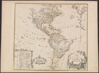
Maps, Atlases & Globes
Description:
Includes text and ill., Library's copy annotated in ink in upper right corner, "12"; and on verso, annotated "Amérique 12" and stamped "Yale, Horace Brown, 1900S.", Relief shown pictorially., and Shows boundaries of lands claimed by the English, French, Spanish
Publisher:
s.n.,
Subject (Geographic):
America--Maps--Early works to 1800
Subject (Name):
Anville, Jean Baptiste Bourguignon d', 1697-1782, Bayly, J, Bellin, Jacques Nicolas, 1703-1772, and Bowles, Thomas, -1767
Found in:
Beinecke Rare Book and Manuscript Library > A map of the whole continent of America : according to D'Anville & Bellin / by L. Delarochette ; Bayly, sculpt.
Creator:
Published / Created:
[1761]
Call Number:
32 L84 1761
Image Count:
1
Resource Type:
Maps, Atlases & Globes
Description:
From London and its environs described ... published by R. & J. Dodsley in 1761. and Mounted on paper bearing manuscript notes in unidentified hand.
Publisher:
Engraved and printed for R. and J. Dodsley in Pall Mall,
Subject (Geographic):
England--London and London (England)--Maps--Early works to 1800.
Subject (Name):
Crace, Frederick, 1779-1859, former owner., Crace, John Gregory, 1809-1889, and Dodsley, James, 1724-1797.
Found in:
Beinecke Rare Book and Manuscript Library > A new and correct plan of London, Westminster and Southwark [cartographic material] : with several additional improvements not in any former survey.
Creator:
Published / Created:
[between 1750 and 1769?]
Call Number:
71 1760C
Container / Volume:
BRBL_00364
Image Count:
1
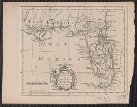
Resource Type:
Maps, Atlases & Globes
Description:
Also shows anchorages, currents, and routes of navigation along the coast., Includes historical notes, text, 10 insets of harbors, and a table showing that "North America is divided into the continent & the islands" according to geography and politics., and Rel
Publisher:
Printed for Robt. Sayer,
Subject (Geographic):
North America--Maps--Early works to 1800
Subject (Name):
Anville, Jean Baptiste Bourguignon d', 1697-1782 and Robert de Vaugondy, Didier, 1723-1786
Found in:
Beinecke Rare Book and Manuscript Library > A new map of North America : with the British, French, Spanish, Dutch & Danish dominions on that great continent; and the West India Islands / done from the latest geographers, with great improvements from the Sieurs d'Anville & Robert.
Branch:v1.61.6 ,Deployed:2024-06-12T09:55:19-04:00