Lucas, Fielding, 1781-1854 Warr, John, b. ca. 1798 Warr, William W
Published / Created:
[1862], c1852
Call Number:
21cea 1862
Image Count:
1
Resource Type:
Maps, Atlases & Globes
Alternative Title:
Chesapeake and Delaware Bays.
Description:
"Drawn by F. Lucas, Jr.", "Engraved by John and William W. Warr, Philadelphia.", "Sold by Lucas Brothers.", Depths shown by soundings and shading., and Includes views: View of the coast from Indian River to Cape Henlopen [Del.] -- Windmill Point [Va.] -- Smiths P
Publisher:
Fielding Lucas,
Subject (Geographic):
Chesapeake Bay Region (Md. and Va.)--Maps and Delaware Bay Region (Del. and N.J.)--Maps
Subject (Topic):
Coasts--Delaware--Maps, Coasts--Maryland--Maps, Coasts--New Jersey--Maps, and Coasts--Virginia--Maps
From: Handbook for travellers in Syria and Palestine, London, 1858, by John Murray. and Two insets: Sketch Map of Jerusalem reduced from the Plan of Symmonds & Tobler and Environs of Jerusalem.
Publisher:
John Murray,
Subject (Geographic):
Palestine--Maps
Subject (Name):
Murray, John. Handbook for travellers in Syria and Palestine, Robinson, Edward, 1794-1863, and Smith, Eli, 1801-1857
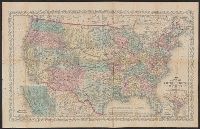
"Entered according to Act of Congress in the year 1856 by Charles Desilver in the clerks office of the District Court of the Eastern District, Also shows proposed western railroad routes., Prime meridians Washington and Greenwich., and Relief shown by hachures.
Publisher:
Charles Desilver,
Subject (Geographic):
United States--Maps
Subject (Name):
Desilver, Charles, Hazzard J. L, and Yeager, E. (Edward)
"Entered according to act of Congress in the year 1856 by Charles Desilver in the clerks office of the district court of the eastern district of Pennsylvania."