Atlas severozapadnykh beregov Ameriki ot Beringova proliva do mysa Korriėntes i ostrovov Aleutskikh s prisovokupleniem nekotorykh mest severovostochnago berega Azii, Gidrograficheskīi︠a︡ zami︠e︡chanīi︠a︡ kʺ atlasu si︠e︡verozapadnykhʺ beregovʺ Ameriki, ostrovovʺ Aleutskikhʺ i ni︠e︡kotorykhʺ drugikhʺ mi︠e︡stʺ Si︠e︡vernago Tikhago okeana, Gidrograficheskii︠a︡ zamechanii︠a︡ k atlasu severozapadnykh beregov Ameriki, ostrovov Aleutskikh i nekotorykh drugikh mest Severnogo Tikhogo okeana, Атлас северозападных берегов Америки от Берингова пролива до мыса Корриэнтес и островов Алеутских с присовокуплением некоторых мест северовосточнoго берега Азии, Гидрографическія замѣчанія къ атласу сѣверозападныхъ береговъ Америки, острововъ Алеутскихъ и нѣкоторыхъ другихъ мѣст Сѣвернаго Тихаго океана, and Гидрографическия замечания к атласу северозападных берегов Америки, островов Алеутских и некоторых других мест Севернoго Тихoго океана
Description:
BEIN EEga 852T: Printed label on inside front cover: Cat. [with manuscript 786]., Includes table of contents for 38 maps (the initial map is unnumbered)., and Accompanied by: Gidrograficheskīi︠a︡ zami︠e︡chanīi︠a︡ k atlasu ... (Sanktpeterburg: Tip. Morskago korpusa, 1852). [4], 7, [1], 148, 17, [3] pages; 17 cm.
Publisher:
publisher not identified
Subject (Geographic):
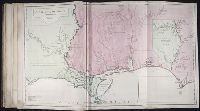
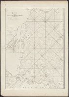
Alaska, California, Pacific Coast (North America), Asia, Pacific Coast., Alaska., California., and North America
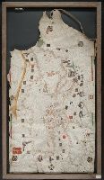
Après de Mannevillette, Jean-Baptiste-Nicolas-Denis d', 1707-1780, cartographer
Published / Created:
[1775?]
Call Number:
27 1775
Image Count:
1
Resource Type:
cartographic image
Description:
Depth shown by soundings., "47" in upper left corner., Appears in Après de Mannevillette's Le Neptune oriental (1775)., and Inset: Plan des Isles Remouw, Kandang, High et Voody située sud-est de l'Isle Sumatra au Détroit de la Sonde.
Publisher:
Chez Demonville
Subject (Geographic):
Sunda Strait (Indonesia), Indonesia, and Sunda Strait.
Freducci, Conte di Ottomano, active 1497-1539, cartographer
Published / Created:
[1536?]
Call Number:
Covers 49 +1536
Image Count:
6
Resource Type:
cartographic image
Description:
Title devised by cataloger., Pen-and-ink in black, red, blue, green, and gold., Four charts, each measuring 33 x 43 cm, mounted on composite boards and edged with vellum, bound in boards covered by blue cloth with label pasted on front cover (No. [1906/242 in manuscript])., and Inscription on third chart (Mediterranean region from the Strait of Gibraltar to the coast of Greece), "Yhs ma [ver]go Conte freducci de ancona la facta nela[n]no MCCCCCXXXVJ."
Publisher:
Conte di Ottomano Freducci
Subject (Geographic):
Mediterranean Region, North Atlantic Ocean, and Baltic Sea
BEIN Art Storage 49cea 1425: Imperfect: lower left corner and bottom edge torn, with some loss of map; slight holes throughout. With leather thone tie on left edge., Portolan chart with seaport names given for all coastlines., Title devised by cataloger., Pen-and-ink in black, red, blue and green., Constantinople shown still in Christian possession; Thrace in possession of the Turks., Contains two compass roses., and Decoration: city views with banners.
Title supplied by cataloger., Nineteenth century forgery of a portlan chart., Manuscript note in accompanying case: A manuscript portolan on vellum probably executed by a Spanish chartmaker circa 1550, the coasts outlined in green with place names in gothic letters of red and black, decorated with devices of the sun and moon in umber heightened with gold, 14 x 9 inches. This chart is a rare example from its unusally small size. RH. 7487., and Pen and ink wash color on parchment, in Italian, in unidentified hand.
Twentieth century forgery of a portlan chart with seaport names given for all coastlines; based on chart from the circle of Vesconte Maggiolo., Title devised by cataloger., Pen-and-ink in gold, brown, red, blue, and green., Contains eight compass roses., Decoration: armorial shields, city views with gilded banners, tents, and Madonna with child., Pasted on wood backing with modern brocade edging., and Coordinates not present on map and are approximated.
Subject (Geographic):
Mediterranean Sea, North Atlantic Ocean, Black Sea, Africa, West, Mediterranean Sea., North Atlantic Ocean., Black Sea., and Africa, West.
Title devised by cataloger., "Vinc[enti]us demetrei Volcius Rachuseus. Fecit interra Liiburni die 24 Maius 1601.", With blue cloth tie at left edge., Color: red, blue, and some gold., With four compass roses., and Coordinates not present on map and are approximated.