
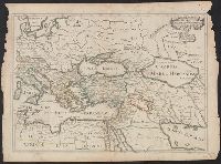
You Searched For
1 - 13 of 13
Search Results


- Creator:
- Ogilby, John, 1600-1676
- Published / Created:
- 1670]
- Call Number:
- 66 1670A
- Container / Volume:
- BRBL_00347
- Image Count:
- 1
- Resource Type:
- Maps, Atlases & Globes
- Description:
- From Ogilby's Africa, being an accurate description of the regions of Egypt, Barbary, Lybia and Billedulgerid. 1670., Has watermarks., Includes ill. and decorative cartouche., and Relief shown pictorially.
- Publisher:
- Printed by T. Johnson for the author,
- Subject (Geographic):
- Africa, Central--Maps--Early works to 1800, Africa, Eastern--Maps--Early works to 1800, and Africa, North--Maps--Early works to 1800
- Subject (Name):
- Ogilby, John, 1600-1676. Africa, being an accurate description of the regions of Egypt, Barbary, Lybia and Billedulgerid
- Found in:
- Beinecke Rare Book and Manuscript Library > Aethiopia superior vel interior vulgo Abissinorum sive Presbiteriioannis Imperior.
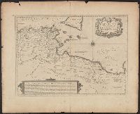
- Creator:
- Jansson, Jan, 1588-1664, cartographer
- Published / Created:
- 1652?]
- Call Number:
- 60 1652
- Container / Volume:
- BRBL_00321
- Image Count:
- 1
- Resource Type:
- Maps, Atlases & Globes
- Alternative Title:
- Africae propriae tabula
- Description:
- Appeared in Jansson's Accuratissima orbis antiqui delineatio., Manuscript number in upper left corner: 51., Relief shown pictorially., and Watermark.
- Publisher:
- J. Janssonius,
- Subject (Geographic):
- Africa, North--Maps--Early works to 1800, Libya--Maps--Early works to 1800, and Tunisia--Maps--Early works to 1800
- Subject (Name):
- Jansson, Jan, 1588-1664. Accuratissima orbis antiqui delineatio
- Found in:
- Beinecke Rare Book and Manuscript Library > Africae propriae tabvla [cartographic material] : in qua Punica regna vides, Tyrios et Agenoris urbem.
- Creator:
- Ogilby, John, 1600-1676
- Published / Created:
- 1670]
- Call Number:
- 66 1670
- Container / Volume:
- BRBL_00347
- Image Count:
- 1
- Resource Type:
- Maps, Atlases & Globes
- Description:
- From Ogilby's Africa, being an accurate description of the regions of Egypt, Barbary, Lybia and Billedulgerid. 1670., Has watermarks., Includes ill. and decorative cartouche., and Relief shown pictorially.
- Publisher:
- Printed by T. Johnson for the author,
- Subject (Geographic):
- Africa, North--Maps--Early works to 1800
- Subject (Name):
- Ogilby, John, 1600-1676. Africa, being an accurate description of the regions of Egypt, Barbary, Lybia and Billedulgerid
- Found in:
- Beinecke Rare Book and Manuscript Library > Barbaria Biledulgerid o: Libye et pars Nigritarum terra.
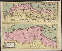
- Creator:
- Blaeu, Joan, 1596-1673
- Published / Created:
- ca. 1670]
- Call Number:
- 66 1700
- Container / Volume:
- BRBL_00347
- Image Count:
- 1
- Resource Type:
- Maps, Atlases & Globes
- Description:
- Ferro meridian., From Bleau's Atlas major (German ed.). Zu Amsterdam : Bey Johannem Blaeu, [ca. 1670]., Relief shown pictorially., and Sheet measures 52 x 62.2 cm.
- Publisher:
- Joan Blaeu,
- Subject (Geographic):
- Africa, North--Maps--Early works to 1800
- Subject (Name):
- Blaeu, Joan, 1596-1673. Atlas maior. German and Rodriguez, José M.--Bookplate
- Found in:
- Beinecke Rare Book and Manuscript Library > Barbaria [cartographic material].
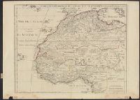
- Creator:
- L'Isle, Guillaume de, 1675-1726
- Published / Created:
- 1707 [i.e. 1718?]
- Call Number:
- 66 1718
- Container / Volume:
- BRBL_00347
- Image Count:
- 1
- Resource Type:
- Maps, Atlases & Globes
- Description:
- "Avec privil, "The words 'premier geographe du Roi' added in the title ... [indicate] that [a map] could not have been issued before 1718 when [De l'Isle] was appointed to that office"--Tooley, R.V. Guide to maps of Africa, p. 68., and Relief shown pictorially.
- Publisher:
- chez l'auteur fur le Quai de l'Horloge a l'Aigle d'Or,
- Subject (Geographic):
- Africa, North--Maps--Early works to 1800 and Africa, West--Maps--Early works to 1800
- Subject (Name):
- Inselin, C
- Found in:
- Beinecke Rare Book and Manuscript Library > Carte de la Barbarie, de la Nigritie, et de la Guinée / par Guillaume Del'Isle de l'academie royale des sciences, premier geographe du Roy ; C. Inselin sculpsit.
- Creator:
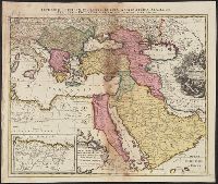
- Sanson, Nicolas, 1600-1667, cartographer
- Call Number:
- 501 1708
- Container / Volume:
- BRBL_00275
- Image Count:
- 1
- Resource Type:
- Maps, Atlases & Globes
- Description:
- Appears in Jaillot's Atlas françois., Includes six bar scales., Prime meridian: Ferro., Relief shown pictorially., Sheet measures 57.3 x 72.2 cm., and Watermark.
- Subject (Geographic):
- Africa, North--Maps--Early works to 1800, Europe, Southern--Maps--Early works to 1800, Middle East--Maps--Early works to 1800, and Turkey--Maps--Early works to 1800
- Subject (Name):
- Albany Institute Stamp, Cordier, Louis, -1711, engraver, and Jaillot, Alexis Hubert, 1632?-1712. Atlas françois
- Found in:
- Beinecke Rare Book and Manuscript Library > Estats de l'Empire du grand Seigneur des Turcs en Europe, en Asie et en Afrique : divise en tous ses Beglerbeglicz ou Gouvernements ou sont aussi remarques les Estats qui luy sont Tributaires dresse sur les plus nouvelles relations / par le Sr. Sanson ...
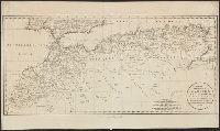
- Creator:
- López de Vargas Machuca, Tomás, 1731-1802
- Published / Created:
- 1789
- Call Number:
- 67 1789
- Container / Volume:
- BRBL_00348
- Image Count:
- 1
- Resource Type:
- Maps, Atlases & Globes
- Description:
- "Zufinden in eigenem Verlage in Wien.", Boundaries hand-colored., Numbered upper right: 106., Probably detached from: Schraembl, Franz Anton. Allgemeiner grosser atlass, Wien: P.J. Schalbacher, 1800., Relief shown pictorially., and Watermark.
- Publisher:
- P. J. Schalbacher],
- Subject (Geographic):
- Africa, North--Maps--Early works to 1800 and Morocco--Maps--Early works to 1800
- Subject (Name):
- Schrämbl, Franz Anton, 1751-1803. Allgemeiner grosser atlass
- Found in:
- Beinecke Rare Book and Manuscript Library > Generalkarte der Koenigreiche Marokko, Fez, Algier und Tunis [cartographic material] / nach den besten Karten und neuesten Nachrichten verfasst von Don Lopez y Vargas &, Geographen des Koenigs in Spanien &. neu herausgegeben von Herrn F. A. Schraembl.
9.
- Creator:
- Sanson, Nicolas, 1600-1667
- Published / Created:
- 1655
- Call Number:
- 655 1655
- Container / Volume:
- BRBL_00345
- Image Count:
- 1
- Resource Type:
- Maps, Atlases & Globes
- Description:
- "Avec privilege du Roy, pour vingt ans.", "La coste des Negres, et Guinee, &c. est apres les observations de Samuel Blomart.", Has watermark., Relief shown pictorially., and Verso: numbered "24" in ink in upper right corner.
- Publisher:
- Chez Pierre Mariette, rue St. Iacques a l'Esperance,
- Subject (Geographic):
- Africa, North--Maps--Early works to 1800 and Africa, West--Maps--Early works to 1800
- Subject (Name):
- Blomart, Samuel and Somer Pruthenus, I
- Found in:
- Beinecke Rare Book and Manuscript Library > L'Afrique, ou Libie ulterieure : ou sont le Saara, ou desert, le pays des Negres, la Guinee, et les pays circonv. tirée en partie de Sanut, et de l'Arabe de Nubie, en partie de diverses cartes veües jusques a present / par le S. Sanson d'Abbeville, geog
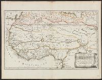
- Creator:
- Mariette, Pierre, 1603-1657, publisher
Sanson, Nicolas, 1600-1667, cartographer
Sanson, Nicolas, 1600-1667. Cartes générales de toutes les parties du monde
Tavernier, Melchior, -1641 - Published / Created:
- 1637
- Call Number:
- 314 1637
- Container / Volume:
- BRBL_00038
- Image Count:
- 1
- Resource Type:
- Maps, Atlases & Globes
- Description:
- Appeared in Sanson's Cartes générales de toutes les parties du monde (1658)., No 3: Imperfect: chewed in upper right corner, with no loss of text. Sheet measures 45.2 x 62.3 cm., Prime meridian: Ferro., Relief shown pictorially., and Watermark.
- Publisher:
- par M. Tauernier graueur & imprimeur du roy et a present chez Pierre Mariette rue S. Iacques a l'esperance,
- Subject (Geographic):
- Africa, North--Maps--Early works to 1800, Europe, Southern--Maps--Early works to 1800, and Middle East--Maps--Early works to 1800
- Found in:
- Beinecke Rare Book and Manuscript Library > Romani Imperii qua oriens est descriptio geographica / auct. N. Sanson ...
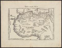
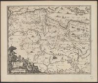
- Creator:
- Fries, Lorenz, ca. 1490-1531
- Published / Created:
- 1541?]
- Call Number:
- 655 1541
- Container / Volume:
- BRBL_00345
- Image Count:
- 1
- Resource Type:
- Maps, Atlases & Globes
- Alternative Title:
- Tabula nova partis Africae
- Description:
- Covers western and northern Africa., Includes ill., On verso: 38., Relief shown pictorially., and Watermark: Bunch of grapes.
- Publisher:
- J. Grüninger?,
- Subject (Geographic):
- Africa, North--Maps--Early works to 1800 and Africa, West--Maps--Early works to 1800
- Found in:
- Beinecke Rare Book and Manuscript Library > Tabula noua partis Africae.
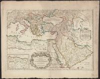
- Creator:
- Sanson, Nicolas, 1600-1667
- Published / Created:
- 1700?]
- Call Number:
- 501 1700
- Container / Volume:
- BRBL_00275
- Image Count:
- 1
- Resource Type:
- Maps, Atlases & Globes
- Alternative Title:
- Imperium Turcicum, complectens Europae, Asiae et Africae, Arabiae que regiones ac provincias plurimas, industria et labore Sr. Sanson
- Description:
- Includes four bar scales., Inset map [partially obscuring title in cartouche] is continuation of the North African coastline., Prime meridian: Ferro., Reinforced on back with paper. Sheet measures 51.5 x 61.0 cm., and Relief shown pictorially.
- Publisher:
- s.n.,
- Subject (Geographic):
- Africa, North--Maps--Early works to 1800, Europe, Southern--Maps--Early works to 1800, Middle East--Maps--Early works to 1800, and Turkey--Maps--Early works to 1800
- Found in:
- Beinecke Rare Book and Manuscript Library > [Est]ats de L'Empire du Grand Seigneur des Turcs en Europe, en Asie, et en Afrique : divise en touts ses beglerbeglicz ou gouvernements ou sont aussi remarques les Estats qui luy sont Tributaires dresse sur les plus nouvelles relations / par le Sr. Sanson
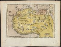
- Creator:
- Fries, Lorenz, ca. 1490-1531
- Published / Created:
- 1522?]
- Call Number:
- 66 1522
- Container / Volume:
- BRBL_00347
- Image Count:
- 2
- Resource Type:
- Maps, Atlases & Globes
- Alternative Title:
- Partis Aphricae, et tabula secunde partis Aphricae
- Description:
- Title supplied by cataloger. and Verso: Latin text, Masonic square and compasses.
- Subject (Geographic):
- Africa, North--Maps--Early works to 1800
- Subject (Name):
- Freemasons--Insignia--Maps--Early works to 1800
- Found in:
- Beinecke Rare Book and Manuscript Library > [Map of northern Africa].