Search
You Searched For
Search Results
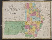
- Creator:
- Mitchell, S. Augustus (Samuel Augustus), 1792-1868
- Published / Created:
- 1833
- Call Number:
- 80 1833
- Container / Volume:
- BRBL_00532
- Image Count:
- 1
- Resource Type:
- Maps, Atlases & Globes
- Found in:
- Beinecke Rare Book and Manuscript Library > Map of the state of Missouri and territory of Arkansas / compiled from the latest authorities ; J.H. Young, sc.
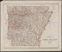
- Creator:
- United States. General Land Office
- Published / Created:
- 1901
- Call Number:
- 818 1901
- Container / Volume:
- BRBL_00565
- Image Count:
- 1
- Resource Type:
- Maps, Atlases & Globes
- Found in:
- Beinecke Rare Book and Manuscript Library > Map of the state of Arkansas / compiled from the official records of the General Land Office and other sources under the direction of Harry King ; compiled and drawn by E.B. Olney ; lettered by Wm. Bauman, Jr.
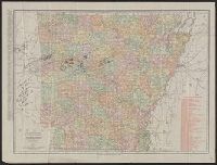
- Creator:
- Rand McNally and Company
- Published / Created:
- 1911
- Call Number:
- 818 1911
- Container / Volume:
- BRBL_00565
- Image Count:
- 1
- Resource Type:
- Maps, Atlases & Globes
- Found in:
- Beinecke Rare Book and Manuscript Library > Arkansas.
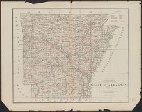
- Creator:
- United States. General Land Office
- Published / Created:
- 1878
- Call Number:
- 818 1878
- Container / Volume:
- BRBL_00565
- Image Count:
- 1
- Resource Type:
- Maps, Atlases & Globes
- Found in:
- Beinecke Rare Book and Manuscript Library > State of Arkansas / compiled from the official records of the General Land Office and other sources by C. Roeser, Principal Draughtsman, GLO, Department of the Interior.
- Creator:
- Rand McNally and Company
- Published / Created:
- 1912
- Call Number:
- 818 1912
- Container / Volume:
- BRBL_00565
- Image Count:
- 1
- Resource Type:
- Maps, Atlases & Globes
- Found in:
- Beinecke Rare Book and Manuscript Library > The Rand-McNally new commercial atlas map of Arkansas.
- Published / Created:
- 1845?]
- Call Number:
- 818fb 1845
- Container / Volume:
- BRBL_00565
- Image Count:
- 1
- Resource Type:
- Maps, Atlases & Globes
- Found in:
- Beinecke Rare Book and Manuscript Library > Map of the south western district, Louisiana ; South eastern district, Louisiana ; Map of the district north of Red River and part of N.W. District, LA. / Surveyor Generals Office, Donaldson, Oct. 29th 1845, P.T. Landry, Sur. Genl. La. Arkansas / Wm. Pel
- Creator:
- General Drafting Company, inc
- Published / Created:
- [1931]
- Call Number:
- 818gmb 1931
- Container / Volume:
- BRBL_00565
- Image Count:
- 2
- Resource Type:
- Maps, Atlases & Globes
- Found in:
- Beinecke Rare Book and Manuscript Library > Magnolia road map of Arkansas and Louisiana / General Drafting Co. Inc.
- Creator:
- General Drafting Company, inc
- Published / Created:
- [1940]
- Call Number:
- 818gmb 1940
- Container / Volume:
- BRBL_00565
- Image Count:
- 2
- Resource Type:
- Maps, Atlases & Globes
- Found in:
- Beinecke Rare Book and Manuscript Library > Happy motoring in Arkansas, Louisiana, and Mississippi / [prepared for] Standard Oil Company of Louisiana.
- Creator:
- H.M. Gousha Company
- Published / Created:
- [1938]
- Call Number:
- 818gmb 1938
- Container / Volume:
- BRBL_00565
- Image Count:
- 2
- Resource Type:
- Maps, Atlases & Globes
- Found in:
- Beinecke Rare Book and Manuscript Library > 1938 official road map, Arkansas / [prepared for] Phillips Petroleum Company.
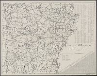
- Creator:
- Arkansas. State Highway Commission
- Published / Created:
- 1945
- Call Number:
- 818gmb 1945
- Container / Volume:
- BRBL_00565
- Image Count:
- 2
- Resource Type:
- Maps, Atlases & Globes
- Found in:
- Beinecke Rare Book and Manuscript Library > Map of the state highway system of Arkansas / issued by Arkansas State Highway Commission.