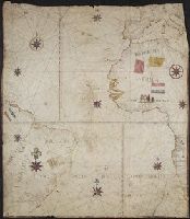
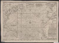
Following is the description of the chart from Auktion XXXVIII, p. 72, published by Haus der Bücher AG and L'Art Ancien S.A.: "Portolankarte. Anonyme portugiesische Seekarte von Teilen des atlantischen Ozeans. Portugal, 17. J and Title supplied by cataloger.
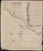
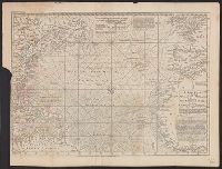
A sea chart with a variety of measuring scales and rumb lines., Appeared in Robijn's Zeeatlas (1683); see Koeman, C. Atlantes Neerlandici, IV, p. 438 (Rob 1, map 18)., and Imperfect: mutilated, with some loss of cartouche. Backed with linen. Cross Collection 62.
Publisher:
By Jacobus Robyn,
Subject (Geographic):
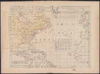
Atlantic Ocean--Maps--Early works to 1800, Brazil--Maps--Early works to 1800, Cape Verde--Maps--Early works to 1800, and New Guinea--Maps--Early works to 1800
Subject (Name):
Robijn, Jacobus, -approximately 1710. Zeeatlas
Subject (Topic):
Nautical charts--Atlantic Ocean--Early works to 1800
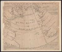
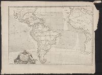
A fan shaped projection centering about the "Western or Atlantic Ocean" from the Polar Circle to the Equator. Four explanations, one in each corner. Latest treaty date given is 1720.
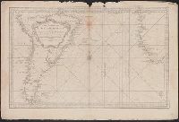
"Longitude w. from London.", "Plate III. The dominions ceded by France & Spain to Great Britain are colored with a feint red.", Accompanied by 2 leaves intended to be hinged to the margin as overlays to North America: Plate I. Clai, and Relief shown pictorially.
Subject (Geographic):
Atlantic Ocean--Maps--Early works to 1800 and North America--Maps--Early works to 1800