Search
You Searched For
Search Results
- Creator:
- Ordnance Survey of Great Britain and Ireland
Royal Geographical Society (Great Britain). Geographical Section
- Published / Created:
- 1915
- Call Number:
- 11hcf 1919E-5
- Container / Volume:
- BRBL_00010ZA
- Image Count:
- 1
- Resource Type:
- Maps, Atlases & Globes
- Alternative Title:
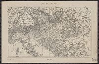
- Europe 1:1,000,000, G.S.G.S. ; no. 2758, and G.S.G.S. ; no. 2758.
- Description:
- Copy 2 ms. notes, hand col. spots on map.
- Publisher:
- Ordnance Survey,
- Subject (Geographic):
- Austria--Maps and Europe, Eastern--Maps
- Found in:
- Beinecke Rare Book and Manuscript Library > (Vienna) Wien : North M 33. / compiled at the Royal Geographical Society under the direction of the Geographical Section ; drawn and printed by Ordnance Survey.
- Creator:
- Ordnance Survey of Great Britain and Ireland
Royal Geographical Society (Great Britain). Geographical Section
- Published / Created:
- 1918
- Call Number:
- 11hcf 1919E-6
- Container / Volume:
- BRBL_00010ZA
- Image Count:
- 1
- Resource Type:
- Maps, Atlases & Globes
- Alternative Title:
- Europe 1:1,000,000, G.S.G.S. ; no. 2758, and G.S.G.S. ; no. 2758.
- Description:
- "Minor corrections December 1918."
- Publisher:
- Ordnance Survey,
- Subject (Geographic):
- Austria--Maps and Europe, Eastern--Maps
- Found in:
- Beinecke Rare Book and Manuscript Library > (Vienna) Wien : North M 33. / compiled at the Royal Geographical Society under the direction of the Geographical Section ; drawn and printed by Ordnance Survey.
- Creator:
- Ordnance Survey of Great Britain and Ireland
Royal Geographical Society (Great Britain). Geographical Section
- Published / Created:
- 1915
- Call Number:
- 11hcf 1919E-5
- Container / Volume:
- BRBL_00010ZA
- Image Count:
- 1
- Resource Type:
- Maps, Atlases & Globes
- Alternative Title:
- Europe 1:1,000,000, G.S.G.S. ; no. 2758, and G.S.G.S. ; no. 2758.
- Description:
- Includes index to adjoining sheets, index to boundaries, and pronunciation glossary.
- Publisher:
- Ordnance Survey,
- Subject (Geographic):
- Austria--Maps and Europe, Eastern--Maps
- Found in:
- Beinecke Rare Book and Manuscript Library > (Vienna) Wien : North M 33. / compiled at the Royal Geographical Society under the direction of the Geographical Section ; drawn and printed by Ordnance Survey.
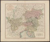
- Published / Created:
- 1811
- Call Number:
- 41 AU79 1811
- Container / Volume:
- BRBL_00242
- Image Count:
- 1
- Resource Type:
- Maps, Atlases & Globes
- Publisher:
- J. Cary,
- Subject (Geographic):
- Austria--Maps and Hungary--Maps
- Found in:
- Beinecke Rare Book and Manuscript Library > A new map of the circle of Austria ... / by John Cary, engraver.
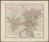
- Published / Created:
- 1801
- Call Number:
- 41 AU79 1801
- Container / Volume:
- BRBL_00242
- Image Count:
- 1
- Resource Type:
- Maps, Atlases & Globes
- Publisher:
- J. Cary,
- Subject (Geographic):
- Austria--Maps and Hungary--Maps
- Found in:
- Beinecke Rare Book and Manuscript Library > A new map of the circle of Austria ... / by John Cary, engraver.
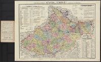
- Creator:
- Artaria & Co
- Published / Created:
- 1907
- Call Number:
- 11hcf 1919
- Image Count:
- 2
- Resource Type:
- Maps, Atlases & Globes
- Alternative Title:
- Artaria's General Karten der österreichischen und ungarischen lander and Mähren und Schlesien
- Description:
- Col. ms. notes on body of map.
- Publisher:
- Artaria & Co.,
- Subject (Geographic):
- Austria--Maps and Hungary--Maps
- Found in:
- Beinecke Rare Book and Manuscript Library > A.Steinhausers karte v. Mähren und Schlesien / bearbeitet v. Dr. K. Peucker.
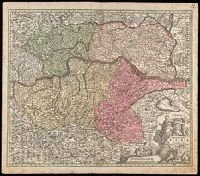
- Creator:
- Seutter, Matthaeus, 1678-1756
- Published / Created:
- [after 1741]
- Call Number:
- BrSides Double Folio 2019 46
- Image Count:
- 1
- Resource Type:
- Maps, Atlases & Globes
- Description:
- "Cum gratia et privil. S.R.I. Vicariat[us], in partib[us] Rheni, Suevice, et juris Franconici."
- Publisher:
- [Mattaeus Seutter]
- Subject (Geographic):
- Austria--Maps
- Found in:
- Beinecke Rare Book and Manuscript Library > Archiducatus Austriae inferioris accuratissima tabula : cujus ditiones in suos quadrant. / designatae edita opera et studio M. Seutt. Ch. Aug.
- Published / Created:
- 191-.
- Call Number:
- 11hcf 1919-42
- Container / Volume:
- BRBL_00010L
- Image Count:
- 1
- Resource Type:
- Maps, Atlases & Globes
- Publisher:
- s.n,
- Subject (Geographic):
- Austria--Maps and Hungary--Maps
- Found in:
- Beinecke Rare Book and Manuscript Library > Austria Hungary.
- Published / Created:
- 191-.
- Call Number:
- 11hcf 1919-41
- Container / Volume:
- BRBL_00010L
- Image Count:
- 1
- Resource Type:
- Maps, Atlases & Globes
- Publisher:
- s.n,
- Subject (Geographic):
- Austria--Maps and Hungary--Maps
- Found in:
- Beinecke Rare Book and Manuscript Library > Austria Hungary.
- Creator:
- United States. Office of Strategic Services. Research and Analysis Branch
- Published / Created:
- 1944
- Call Number:
- 42gmb 1944
- Container / Volume:
- BRBL_00245
- Image Count:
- 1
- Resource Type:
- Maps, Atlases & Globes
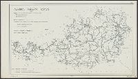
- Description:
- Indicates left- and right- hand driving zones and snow clearing.
- Publisher:
- Lithographed in the Reproduction Branch, OSS,
- Subject (Geographic):
- Austria--Maps
- Subject (Name):
- United States. Office of Strategic Services. Reproduction Branch
- Subject (Topic):
- Roads--Austria--Maps and Snow removal--Austria--Maps
- Found in:
- Beinecke Rare Book and Manuscript Library > Austria [cartographic material] : Federal roads 1937.