Skip to search
Skip to main content
Skip to first result
Search
You Searched For
Subject (Geographic)
Austria--Maps
New Search
Search Results
Creator:
Published / Created:
1915
Call Number:
11hcf 1919E-5
Container / Volume:
BRBL_00010ZA
Image Count:
1
Resource Type:
Maps, Atlases & Globes
Alternative Title:
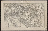
Europe 1:1,000,000, G.S.G.S. ; no. 2758, and G.S.G.S. ; no. 2758.
Description:
Copy 2 ms. notes, hand col. spots on map. and Includes index to adjoining sheets, index to boundaries, and pronunciation glossary.
Publisher:
Ordnance Survey,
Subject (Geographic):
Austria--Maps and Europe, Eastern--Maps
Found in:
Beinecke Rare Book and Manuscript Library > (Vienna) Wien : North M 33. / compiled at the Royal Geographical Society under the direction of the Geographical Section ; drawn and printed by Ordnance Survey.
Creator:
Published / Created:
1918
Call Number:
11hcf 1919E-6
Container / Volume:
BRBL_00010ZA
Image Count:
1
Resource Type:
Maps, Atlases & Globes
Alternative Title:
Europe 1:1,000,000, G.S.G.S. ; no. 2758, and G.S.G.S. ; no. 2758.
Description:
"Minor corrections December 1918." and Includes index to adjoining sheets, index to boundaries, and pronunciation glossary.
Publisher:
Ordnance Survey,
Subject (Geographic):
Austria--Maps and Europe, Eastern--Maps
Found in:
Beinecke Rare Book and Manuscript Library > (Vienna) Wien : North M 33. / compiled at the Royal Geographical Society under the direction of the Geographical Section ; drawn and printed by Ordnance Survey.
Creator:
Published / Created:
1915
Call Number:
11hcf 1919E-5
Container / Volume:
BRBL_00010ZA
Image Count:
1
Resource Type:
Maps, Atlases & Globes
Alternative Title:
Europe 1:1,000,000, G.S.G.S. ; no. 2758, and G.S.G.S. ; no. 2758.
Description:
Includes index to adjoining sheets, index to boundaries, and pronunciation glossary.
Publisher:
Ordnance Survey,
Subject (Geographic):
Austria--Maps and Europe, Eastern--Maps
Found in:
Beinecke Rare Book and Manuscript Library > (Vienna) Wien : North M 33. / compiled at the Royal Geographical Society under the direction of the Geographical Section ; drawn and printed by Ordnance Survey.
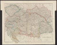
Published / Created:
1811
Call Number:
41 AU79 1811
Container / Volume:
BRBL_00242
Image Count:
1
Resource Type:
Maps, Atlases & Globes
Publisher:
J. Cary,
Subject (Geographic):
Austria--Maps and Hungary--Maps
Found in:
Beinecke Rare Book and Manuscript Library > A new map of the circle of Austria ... / by John Cary, engraver.
Published / Created:
1801
Call Number:
41 AU79 1801
Container / Volume:
BRBL_00242
Image Count:
1
Resource Type:
Maps, Atlases & Globes
Publisher:
J. Cary,
Subject (Geographic):
Austria--Maps and Hungary--Maps
Found in:
Beinecke Rare Book and Manuscript Library > A new map of the circle of Austria ... / by John Cary, engraver.
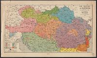
Creator:
Published / Created:
1907
Call Number:
11hcf 1919
Image Count:
2
Resource Type:
Maps, Atlases & Globes
Alternative Title:
Artaria's General Karten der österreichischen und ungarischen lander and Mähren und Schlesien
Description:
Col. ms. notes on body of map. and Includes charts showing political judicial divisions.
Publisher:
Artaria & Co.,
Subject (Geographic):
Austria--Maps and Hungary--Maps
Found in:
Beinecke Rare Book and Manuscript Library > A.Steinhausers karte v. Mähren und Schlesien / bearbeitet v. Dr. K. Peucker.
Creator:
Published / Created:
[after 1741]
Call Number:
BrSides Double Folio 2019 46
Image Count:
1
Resource Type:
Maps, Atlases & Globes
Description:
"Cum gratia et privil. S.R.I. Vicariat[us], in partib[us] Rheni, Suevice, et juris Franconici.", Manuscript number in upper right corner: 11. From the Karpinski-von Wieser Map Collection., Relief shown pictorially., and With reference grid.
Publisher:
[Mattaeus Seutter]
Subject (Geographic):
Austria--Maps
Found in:
Beinecke Rare Book and Manuscript Library > Archiducatus Austriae inferioris accuratissima tabula : cujus ditiones in suos quadrant. / designatae edita opera et studio M. Seutt. Ch. Aug.
Published / Created:
191-.
Call Number:
11hcf 1919-42
Container / Volume:
BRBL_00010L
Image Count:
1
Resource Type:
Maps, Atlases & Globes
Publisher:
s.n,
Subject (Geographic):
Austria--Maps and Hungary--Maps
Found in:
Beinecke Rare Book and Manuscript Library > Austria Hungary.
Published / Created:
191-.
Call Number:
11hcf 1919-41
Container / Volume:
BRBL_00010L
Image Count:
1
Resource Type:
Maps, Atlases & Globes
Publisher:
s.n,
Subject (Geographic):
Austria--Maps and Hungary--Maps
Found in:
Beinecke Rare Book and Manuscript Library > Austria Hungary.
Creator:
Published / Created:
1944
Call Number:
42gmb 1944
Container / Volume:
BRBL_00245
Image Count:
1
Resource Type:
Maps, Atlases & Globes
Description:
Indicates left- and right- hand driving zones and snow clearing., Map in German; legend and overlays in English., and Relief indicated by spot heights.
Publisher:
Lithographed in the Reproduction Branch, OSS,
Subject (Geographic):
Austria--Maps
Subject (Name):
United States. Office of Strategic Services. Reproduction Branch
Subject (Topic):
Roads--Austria--Maps and Snow removal--Austria--Maps
Found in:
Beinecke Rare Book and Manuscript Library > Austria [cartographic material] : Federal roads 1937.
Published / Created:
[1912]
Call Number:
41 1912
Container / Volume:
BRBL_00241
Image Count:
1
Resource Type:
Maps, Atlases & Globes
Description:
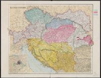
Inset: Environs of Vienna.
Publisher:
George Philip & Son, Ltd.,
Subject (Geographic):
Austria--Maps, Balkan Peninsula--Maps, and Hungary--Maps
Found in:
Beinecke Rare Book and Manuscript Library > Austria-Hungary / The London Geographical Institute.
Published / Created:
[191-?]
Call Number:
11hcf 1919A-23
Container / Volume:
BRBL_00010M
Image Count:
1
Resource Type:
Maps, Atlases & Globes
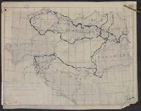
Alternative Title:
Czecho-Slovak claims
Description:
"Dr. Seymour" in upper left corner of sheet., Includes inset of Vienna and environs., Shows "Czecho-Slovak" and "Ruthenian" areas and Austria-Hungary border from 1914., and Title at head of sheet.
Publisher:
s.n.,
Subject (Geographic):
Austria--Maps, Europe, Eastern--Maps, and Hungary--Maps
Found in:
Beinecke Rare Book and Manuscript Library > Austria-Hungary : Czecho-Slovak claims.
Creator:
Published / Created:
1910]
Call Number:
41gc 1910
Container / Volume:
BRBL_00243
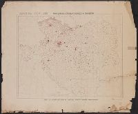
Image Count:
1
Resource Type:
Maps, Atlases & Globes
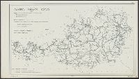
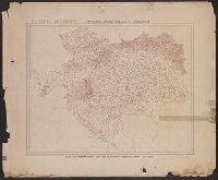
Description:
"Each dot represents 2500 or fractions greater than 1/2 of 2500.
Publisher:
s.n.,
Subject (Geographic):
Austria--Maps, Europe, Eastern--Maps, and Hungary--Maps
Found in:
Beinecke Rare Book and Manuscript Library > Austria-Hungary : Population actively engaged in Agriculture Paul M. Atkins.
Creator:
Published / Created:
1910]
Call Number:
41gf 1910
Container / Volume:
BRBL_00243
Image Count:
1
Resource Type:
Maps, Atlases & Globes
Description:
"Each dot represents 2500 or fractions greater than 1/2 of 2500.
Publisher:
s.n.,
Subject (Geographic):
Austria--Maps, Europe, Eastern--Maps, and Hungary--Maps
Found in:
Beinecke Rare Book and Manuscript Library > Austria-Hungary : Population actively engaged in Industry Paul M. Atkins.
Creator:
Published / Created:
[1914?]
Call Number:
11hcf 1919B-13
Container / Volume:
BRBL_00010O
Image Count:
3
Resource Type:
Maps, Atlases & Globes
Description:
Sheet 2 fragile, in 3 fragments.
Publisher:
American Geographical Society,
Subject (Geographic):
Austria--Maps and Europe, Eastern--Maps
Found in:
Beinecke Rare Book and Manuscript Library > Austria-Hungary [cartographic material].
Creator:
Published / Created:
[191-?]
Call Number:
11hcf 1919A-18
Container / Volume:
BRBL_00010M
Image Count:
2
Resource Type:
Maps, Atlases & Globes
Description:
Includes col. overlay labeled "Cities" showing populations. "No. 6" outside upper right margin of overlay., Includes inset of Vienna and environs, scale 1:1,000,000., and Relief shown by hachures and spot heights.
Publisher:
Longmans, Green & Co.,
Subject (Geographic):
Austria--Maps, Europe, Eastern--Maps, and Hungary--Maps
Found in:
Beinecke Rare Book and Manuscript Library > Austria-Hungary.
Creator:
Published / Created:
[191-?]
Call Number:
11hcf 1919A-21
Container / Volume:
BRBL_00010M
Image Count:
2
Resource Type:
Maps, Atlases & Globes
Alternative Title:
[Claims by races within empire of Austria-Hungary]
Description:
Includes inset of Vienna and environs, scale 1:1,000,000., Paper with inferred title affixed to map above printed title. Includes col. overlay with outlines and labels of countries corresponding wi, and Relief shown by hachures and spot heights.
Publisher:
Longmans & Co.,
Subject (Geographic):
Austria--Maps, Europe, Eastern--Maps, and Hungary--Maps
Found in:
Beinecke Rare Book and Manuscript Library > Austria-Hungary.
Creator:
Published / Created:
[191-?]
Call Number:
11hcf 1919A-19
Container / Volume:
BRBL_00010M
Image Count:
2
Resource Type:
Maps, Atlases & Globes
Alternative Title:
[Speech boundaries and fair geographic lines :
Description:
Include, Paper with inferred title affixed to map around printed title. Includes col. overlay with outlines and labels of countries shown on base map; "No. 2" outside upper right margin of overlay., and Relief shown by hachures and spot heights.
Publisher:
Longmans & Co.,
Subject (Geographic):
Austria--Maps, Europe, Eastern--Maps, and Hungary--Maps
Found in:
Beinecke Rare Book and Manuscript Library > Austria-Hungary.
Creator:
Published / Created:
[191-?]
Call Number:
11hcf 1919A-22
Container / Volume:
BRBL_00010M
Image Count:
2
Resource Type:
Maps, Atlases & Globes
Alternative Title:
[Population density according to Wallis :
Description:
Includes inset of Vienna and environs, scale 1:1,000,000. and Paper with inferred title affixed to map around printed title. Includes col. overlay showing population density with corresponding legend affixed to base map; "No. 4" outside upper
Publisher:
Longmans & Co.,
Subject (Geographic):
Austria--Maps, Europe, Eastern--Maps, and Hungary--Maps
Found in:
Beinecke Rare Book and Manuscript Library > Austria-Hungary.
Published / Created:
1910?]
Call Number:
41 1910A
Container / Volume:
BRBL_00241
Image Count:
1
Resource Type:
Maps, Atlases & Globes
Publisher:
s.n.,
Subject (Geographic):
Austria--Maps, Balkan Peninsula--Maps, and Hungary--Maps
Found in:
Beinecke Rare Book and Manuscript Library > Austria-Hungary.
Creator:
Published / Created:
[191-?]
Call Number:
11hcf 1919A-20
Container / Volume:
BRBL_00010M
Image Count:
2
Resource Type:
Maps, Atlases & Globes
Alternative Title:
[Religion :
Description:
Includes inset of Vienna and environs, scale 1:1,000,000. and Paper with inferred title affixed to map around printed title. Includes col. overlay showing religious denominations with corresponding legend affixed to base map; "No. 14" outside
Publisher:
Longmans & Co.,
Subject (Geographic):
Austria--Maps, Europe, Eastern--Maps, and Hungary--Maps
Found in:
Beinecke Rare Book and Manuscript Library > Austria-Hungary.
Published / Created:
1919?].
Call Number:
11hcf 1919C-3-14
Container / Volume:
BRBL_00010U
Image Count:
1
Resource Type:
Maps, Atlases & Globes
Description:
"610" in upper right and bottom left.
Publisher:
s.n.,
Subject (Geographic):
Austria--Maps and Hungary--Maps
Found in:
Beinecke Rare Book and Manuscript Library > Austria-Hungary.
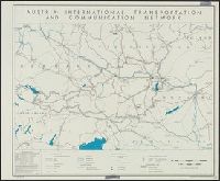
Creator:
Published / Created:
1945
Call Number:
42gm 1945
Container / Volume:
BRBL_00245
Image Count:
1
Resource Type:
Maps, Atlases & Globes
Description:
"Data as of 1938 with some additions to 1944." and "No. 5394."
Publisher:
Reproduction Branch, OSS,
Subject (Geographic):
Austria--Maps
Subject (Topic):
Electric power transmission--Austria--Maps, Telecommunication--Austria--Maps, and Transportation--Austria--Maps
Found in:
Beinecke Rare Book and Manuscript Library > Austria: international transportation and communication network [cartographic material] / R & A, OSS.
Published / Created:
1832
Call Number:
41 1832
Container / Volume:
BRBL_00241
Image Count:
1
Resource Type:
Maps, Atlases & Globes
Publisher:
J. Arrowsmith,
Subject (Geographic):
Austria--Maps and Hungary--Maps
Found in:
Beinecke Rare Book and Manuscript Library > Austrian Empire / by J. Arrowsmith.
Published / Created:
1816
Call Number:
41 1816
Container / Volume:
BRBL_00241
Image Count:
1
Resource Type:
Maps, Atlases & Globes
Description:
Drawn and engraved for Thompson's New General Atlas, 1816.
Subject (Geographic):
Austria--Maps and Europe, Eastern--Maps
Found in:
Beinecke Rare Book and Manuscript Library > Austrian dominions / Neele, sculp.
Published / Created:
1878
Call Number:
11hcf 1919-40
Container / Volume:
BRBL_00010L
Image Count:
1
Resource Type:
Maps, Atlases & Globes
Publisher:
M. Borel,
Subject (Geographic):
Austria--Maps, Bosnia and Hercegovina--Maps, and Hungary--Maps
Found in:
Beinecke Rare Book and Manuscript Library > Carte ethnographique de l'Autriche-Hongrie et des régions habitées par les Roumains / aprés H. Kiepert. Epoque du Congrés de Berlin, 1878.
Published / Created:
[1910]
Call Number:
36gmb 1910A
Container / Volume:
BRBL_00130
Image Count:
1
Resource Type:
Maps, Atlases & Globes
Description:
Dissected and mounted on linen. and Indicates recommended routes for automobiles and bicycles.
Publisher:
A. Taride,
Subject (Geographic):
Austria--Maps and Germany--Maps
Found in:
Beinecke Rare Book and Manuscript Library > Carte routière de l'Allemagne du Sud, Autriche, Tyrol (Grands itinéraires).
Published / Created:
[1845?]
Call Number:
41 1845A
Container / Volume:
BRBL_00241
Image Count:
1
Resource Type:
Maps, Atlases & Globes
Description:
Platt's Grosser Atlas der Erde No. 13.
Publisher:
Rubach'schen,
Subject (Geographic):
Austria--Maps and Hungary--Maps
Found in:
Beinecke Rare Book and Manuscript Library > Das Erz Herzogthum Oesterreich, Steiermark, Kärnthen ... / Lith. Albr. Platt.
Published / Created:
1807
Call Number:
41 AU79 1807
Container / Volume:
BRBL_00242
Image Count:
1
Resource Type:
Maps, Atlases & Globes
Subject (Geographic):
Austria--Maps and Hungary--Maps
Found in:
Beinecke Rare Book and Manuscript Library > Das Land zwischen der Donau, Muhr und Raab ... / bearbeitet u: gezeichnet v: F: W: v: Streit Oberl. ; gestochen v: J: List.
Published / Created:
191-.
Call Number:
11hcf 1919A-2
Container / Volume:
BRBL_00010M
Image Count:
1
Resource Type:
Maps, Atlases & Globes
Description:
Positive photostat of original map of same title, copyright 1903, Gotha: Justus Perthes.
Publisher:
s.n.,
Subject (Geographic):
Austria--Maps
Found in:
Beinecke Rare Book and Manuscript Library > Die Umgangssprache in den Gerichtsbezirken der österreichischen Südetenlander : Map used by CS at discussions of the Czechoslovak Territorial Committee, March, 1918.
Published / Created:
1874
Call Number:
41GMD 1874
Container / Volume:
BRBL_00243
Image Count:
1
Resource Type:
Maps, Atlases & Globes
Description:
Inset: Dampfshiff-Verbinbungen des oesterreichischen Lloyd mit dem Auslande.
Publisher:
R. v. Waldheim,
Subject (Geographic):
Austria--Maps, Europe, Eastern--Maps, and Hungary--Maps
Found in:
Beinecke Rare Book and Manuscript Library > Eisenbahn und Post-Routen-Karte der Osterreichisch-Ungarischen Monarchie.
Published / Created:
[1880]
Call Number:
41gme 1880
Container / Volume:
BRBL_00243
Image Count:
2
Resource Type:
Maps, Atlases & Globes
Publisher:
Eduard Hölzel,
Subject (Geographic):
Austria--Maps and Hungary--Maps
Subject (Topic):
Railroads--Austria and Railroads--Hungary
Found in:
Beinecke Rare Book and Manuscript Library > Eisenbahnkarte von Oesterreich-Ungarn.
Published / Created:
1868
Call Number:
41ED 1868
Container / Volume:
BRBL_00243
Image Count:
1
Resource Type:
Maps, Atlases & Globes
Description:
"Gezeichnet von A. Doležal."
Publisher:
k.k. Hof-u Staats-Druckerei,
Subject (Geographic):
Austria--Maps, Balkan Peninsula--Maps, and Hungary--Maps
Found in:
Beinecke Rare Book and Manuscript Library > Ethnographische Karte Österreich-Ungarischen Monarchie / von Carl Freiherrn von Czoernig.
Published / Created:
1869
Call Number:
425 1869
Container / Volume:
BRBL_00246
Image Count:
1
Resource Type:
Maps, Atlases & Globes
Publisher:
s.n.],
Subject (Geographic):
Austria--Maps
Found in:
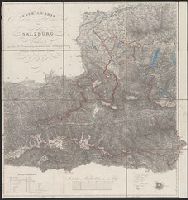
Beinecke Rare Book and Manuscript Library > General Carte von Salzburg nach der von dem K. K. General-Quartiermeister-Staab herausgegebenen Special Carte dieses Landes.
Published / Created:
[1845?]
Call Number:
41 1845
Container / Volume:
BRBL_00241
Image Count:
1
Resource Type:
Maps, Atlases & Globes
Description:
Platt's grosser Atlas der Erde No. 11.
Publisher:
Verlag der Creutz'schen Buchhandlung,
Subject (Geographic):
Austria--Maps and Hungary--Maps
Found in:
Beinecke Rare Book and Manuscript Library > Karte des österreichischen Staat's ... / Lith. Albrecht Platt.
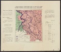
Published / Created:
1919
Call Number:
11hc 1920Z
Container / Volume:
BRBL_00010I
Image Count:
1
Resource Type:
Maps, Atlases & Globes
Alternative Title:
The principles of president Wilson and the Italian aspirations in Carinthia, in the provinces of Gorice and Carniola
Description:
French and English. and Shows "The number of Yugoslavs and of Italians in the contested territory of Carinthia ... according to the Census of 1910."
Publisher:
L. Wuhrer,
Subject (Geographic):
Austria--Maps
Found in:
Beinecke Rare Book and Manuscript Library > Les principes du président Wilson et les aspirations Italiennes en Carinthie, dans la province de Goritz et en Carniole = The principles of president Wilson and the Italian aspirations in Carinthia, in the provinces of Gorice and Carniola / Lith. L. Wuhr
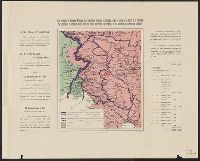
Published / Created:
1919
Call Number:
11hcf 1919-38
Container / Volume:
BRBL_00010L
Image Count:
1
Resource Type:
Maps, Atlases & Globes
Alternative Title:
The principles of president Wilson and the Italian aspirations in Carinthia, in the provinces of Gorice and Carniola
Description:
French and English. and Shows "The number of Yugoslavs and of Italians in the contested territory of Carinthia ... according to the Census of 1910."
Publisher:
L. Wuhrer,
Subject (Geographic):
Austria--Maps
Found in:
Beinecke Rare Book and Manuscript Library > Les principes du président Wilson et les aspirations Italiennes en Carinthie, dans la province de Goritz et en Carniole = The principles of president Wilson and the Italian aspirations in Carinthia, in the provinces of Gorice and Carniola / Lith. L. Wuhr
Published / Created:
191-.
Call Number:
11hcf 1919-39
Container / Volume:
BRBL_00010L
Image Count:
1
Resource Type:
Maps, Atlases & Globes
Description:
"The names of places and regions are written in the language of the respective nationality." and Shows frontiers and languages spoken within map area.
Publisher:
Istituto Geografico de Agostini,
Subject (Geographic):
Austria--Maps, Bosnia and Hercegovina--Maps, and Hungary--Maps
Found in:
Beinecke Rare Book and Manuscript Library > Linguistic map of the Austro-Hungarian Monarchy.
Creator:
Published / Created:
[1854]
Call Number:
491 1853A
Container / Volume:
BRBL_00269
Image Count:
2
Resource Type:
Maps, Atlases & Globes
Alternative Title:
Map of the seat of war and Seat of war in the East.
Description:
At head of map: Map of the seat of war., Cover title: The seat of war in the east : a new map of the frontier provinces of Turkey, Russia & Austria, the Black Sea, &c., and Inset: Map showing in detail the Mouths & part of the River Danube, with the fortified t
Publisher:
Published by Willmer & Rogers, Importers of Foreign Books & Newspapers, 42 & 44 Nassau Street,
Subject (Geographic):
Austria--Maps, Black Sea--Charts, maps, etc, Danube River--Charts, diagrams, etc, Russia (Federation)--Maps, and Turkey--Maps
Subject (Name):
Bevan & Boell (Firm)
Subject (Topic):
Crimean War, 1853-1856--Maps
Found in:
Beinecke Rare Book and Manuscript Library > Map of the frontier provinces of Turkey, Russia & Austria, the Black Sea, & c [cartographic material] / Lith. by Bevan & Boell, 163 Broadway N.Y.
Creator:
Published / Created:
[1854]
Call Number:
53hc 1878
Container / Volume:
BRBL_00287
Image Count:
1
Resource Type:
Maps, Atlases & Globes
Alternative Title:
Map of the seat of war and Seat of war in the East.
Description:
At head of map: Map of the seat of war., Cover title: The seat of war in the east : a new map of the frontier provinces of Turkey, Russia & Austria, the Black Sea, &c., and Inset: Map showing in detail the Mouths & part of the River Danube, with the fortified t
Publisher:
Published by Willmer & Rogers, Importers of Foreign Books & Newspapers, 42 & 44 Nassau Street,
Subject (Geographic):
Austria--Maps, Black Sea--Charts, maps, etc, Danube River--Charts, diagrams, etc, Russia (Federation)--Maps, and Turkey--Maps
Subject (Name):
Bevan & Boell (Firm)
Subject (Topic):
Crimean War, 1853-1856--Maps
Found in:
Beinecke Rare Book and Manuscript Library > Map of the frontier provinces of Turkey, Russia & Austria, the Black Sea, & c [cartographic material] / Lith. by Bevan & Boell, 163 Broadway N.Y.
Creator:
Published / Created:
[1917]
Call Number:
11hc 1919Y
Image Count:
2
Resource Type:
Maps, Atlases & Globes
Description:
Area: from Baltic Sea to Innsbruck ; from Luxemburg to Warsaw., Imperfect. Cover wanting, some text lost., Includes index., and Shows: camps and hospitals for British prisoners, towns, rivers and roads.
Publisher:
Nisbet & Co.,
Subject (Geographic):
Austria--Maps and Germany--Maps
Subject (Topic):
World War, 1914-1918--Maps and World War, 1914-1918--Prisoners and prisons, German--Maps
Found in:
Beinecke Rare Book and Manuscript Library > Map of the main prison camps in Germany and Austria / by Mrs Pope-Hennessy.
Published / Created:
1805
Call Number:
41 1805
Container / Volume:
BRBL_00241
Image Count:
4
Resource Type:
Maps, Atlases & Globes
Publisher:
Artaria et Comp.,
Subject (Geographic):
Austria--Maps and Hungary--Maps
Found in:
Beinecke Rare Book and Manuscript Library > Mappa novissima regnorum Hungariae, Croatiae, Sclavoniae ... / F. Muller, sculpsit.
Published / Created:
1849
Call Number:
41EF 1849
Container / Volume:
BRBL_00243
Image Count:
1
Resource Type:
Maps, Atlases & Globes
Publisher:
R.A. Frohlick,
Subject (Geographic):
Austria--Maps and Hungary--Maps
Found in:
Beinecke Rare Book and Manuscript Library > Neueste National und Sprachenkarte des oesterreichischen Kaiserstaates und der angrenzenden Theile ... / gest. von Fr. Reisser.
Published / Created:
[1865?]
Call Number:
423 1865
Container / Volume:
BRBL_00245
Image Count:
1
Resource Type:
Maps, Atlases & Globes
Description:
In bottom margin: Schrift von W. Kratz ; Terrain v. V. Geyer. and Insets: [1.] Wien und Umgegend, 1:72,000 -- [2.] Profil: Lundenburg-Wien-Semmering-Gratz.
Publisher:
Geographisches Institut,
Subject (Geographic):
Austria--Maps
Found in:
Beinecke Rare Book and Manuscript Library > Nieder und Ober-Oesterreich oder das Erzherzogthum Oesterreich unter & ob der Enns und das Herzogthum Salzburg / Bearbeitet von C. Gräf.
Creator:
Published / Created:
1892
Call Number:
41FCB 1892
Container / Volume:
BRBL_00243
Image Count:
2
Resource Type:
Maps, Atlases & Globes
Description:
Index on margins. and Inset: Die Wahlen des Grossgrundbesitzes u.d. Handelskammern.
Publisher:
G. Freytag & Berndt,
Subject (Geographic):
Austria--Maps and Hungary--Maps
Found in:
Beinecke Rare Book and Manuscript Library > Oesterreichisch-ungarische Reichsraths-Wahlkarte mit den Reichsraths-Wahlen Oesterreichs für die Jahre 1885-1891 und Ungarns für die Jahre 1887-1892 / Entworfen von Béla Grafen Kreith.
Published / Created:
1890-1891.
Call Number:
41 1891
Container / Volume:
BRBL_00241
Image Count:
2
Resource Type:
Maps, Atlases & Globes
Description:
Insets: [1.] Budapest und weitere Umgegend, 1:150,000 -- [2.] Südspitze von Dalmatien.
Publisher:
Justus Perthes,
Subject (Geographic):
Austria--Maps and Europe, Eastern--Maps
Found in:
Beinecke Rare Book and Manuscript Library > Österreich-Ungarn in 4 Blättern / von C. Vogel.
Published / Created:
[1890?]
Call Number:
425 1890
Container / Volume:
BRBL_00246
Image Count:
1
Resource Type:
Maps, Atlases & Globes
Publisher:
G. Freytag & Berndt,
Subject (Geographic):
Austria--Maps
Found in:
Beinecke Rare Book and Manuscript Library > Reise und Wanderkarte fürdas Salzkammergut, Salzburg u. Ost-Tirol, mit Angabe der Hauptanstiegsrichtungen aller häufig bestiegenen Bergspitzen / G. Freytag & H. Hess.
Published / Created:
1915
Call Number:
11hcf 1919-5
Container / Volume:
BRBL_00010L
Image Count:
1
Resource Type:
Maps, Atlases & Globes
Description:
Shows boundaries and elevation, cites & towns.
Publisher:
Freytag & Berndt,
Subject (Geographic):
Austria--Maps
Found in:
Beinecke Rare Book and Manuscript Library > Schulhandkarte des Herzogtums Kärnten / Berbeitet von Franz P.E.H.R.
Published / Created:
1915
Call Number:
11hcf 1919A-17
Container / Volume:
BRBL_00010M
Image Count:
1
Resource Type:
Maps, Atlases & Globes
Description:
Shows boundaries and elevation, cites & towns.
Publisher:
Freytag & Berndt,
Subject (Geographic):
Austria--Maps
Found in:
Beinecke Rare Book and Manuscript Library > Schulhandkarte des Herzogtums Kärnten / Berbeitet von Franz P.E.H.R.
Published / Created:
1913
Call Number:
11hcf 1919-17
Container / Volume:
BRBL_00010J
Image Count:
1
Resource Type:
Maps, Atlases & Globes
Description:
Shows boundaries and elevation, cites & towns.
Publisher:
Freytag & Berndt,
Subject (Geographic):
Austria--Maps
Found in:
Beinecke Rare Book and Manuscript Library > Schulhandkarte des Herzogtums Steiermark / Berbeitet von Hans Trunk.
Branch:v1.62.5 ,Deployed:2024-07-17T14:10:59-04:00