Search
You Searched For
Search Results
- Creator:
- Great Britain. War Office. General Staff. Geographical Section
- Published / Created:
- 1918
- Call Number:
- 356fd 1918A
- Container / Volume:
- BRBL_00114
- Image Count:
- 1
- Resource Type:
- Maps, Atlases & Globes
- Alternative Title:
- GSGS (Series) ; 2888.
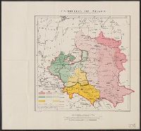
- Description:
- Shows boundaries of Poland in 1772, 1793, 1795 and 1815. To illustrate the post-WW1 settlement.
- Publisher:
- GSGS, War Office,
- Subject (Geographic):
- Belarus--Maps, Lithuania--Maps, Poland--Maps, and Ukraine--Maps
- Found in:
- Beinecke Rare Book and Manuscript Library > Partitions of Poland [cartographic material] : GSGS 2888.
- Creator:
- Minskai︠a︡ kartograficheskai︠a︡ fabrika
- Published / Created:
- c1992.
- Call Number:
- 352 B41 1991
- Container / Volume:
- BRBL_00107
- Image Count:
- 4
- Resource Type:
- Maps, Atlases & Globes
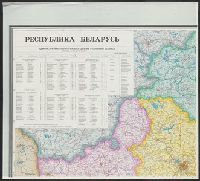
- Description:
- "Administrativno-territorialʹnoe delenie dano
- Publisher:
- MKF,
- Subject (Geographic):
- Belarus--Administrative and political divisions--Maps and Belarus--Maps
- Found in:
- Beinecke Rare Book and Manuscript Library > Respublika Belarusʹ / karta sostavlena i podgotovlena k pechati Minskoĭ kartograficheskoĭ fabrikoĭ v 1991 g.