Search
You Searched For
Search Results
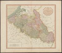
- Creator:
- Cary, John
- Published / Created:
- 1804
- Call Number:
- 335 1804
- Container / Volume:
- BRBL_00086
- Image Count:
- 1
- Resource Type:
- Maps, Atlases & Globes
- Found in:
- Beinecke Rare Book and Manuscript Library > A new map of the Netherlands also of that part of Germany westward of the Rhine as ceded to the French and divided into their several Departments from the latest authorities / by John Cary, Engraver, 1804.
- Creator:
- Cary, John
- Published / Created:
- 1811
- Call Number:
- 335 1811
- Container / Volume:
- BRBL_00086
- Image Count:
- 1
- Resource Type:
- Maps, Atlases & Globes
- Found in:
- Beinecke Rare Book and Manuscript Library > A new map of the Netherlands also of that part of Germany westward of the Rhine as ceded to the French and divided into their several Departments from the latest authorities / by John Cary, Engraver, 1811.
- Published / Created:
- 191-.
- Call Number:
- 11hcf 1919D-29
- Container / Volume:
- BRBL_00010X
- Image Count:
- 1
- Resource Type:
- Maps, Atlases & Globes
- Found in:
- Beinecke Rare Book and Manuscript Library > Belgique : Carte Administrative et Commerciale; chemins de fer, canaux, routes / publiée par "The Scarborough Co.", Éditeurs de Cartes Géographiques.
- Creator:
- United States. Office of Strategic Services
- Published / Created:
- 1942
- Call Number:
- 335gfb 1942A
- Container / Volume:
- BRBL_00087
- Image Count:
- 1
- Resource Type:
- Maps, Atlases & Globes
- Found in:
- Beinecke Rare Book and Manuscript Library > Belgium Generation and Transmission of Electrical Energy / compiled and drawn in Geography Division, O.S.S.
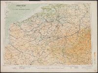
- Creator:
- Great Britain. War Office. General Staff. Geographical Section
- Published / Created:
- 1910
- Call Number:
- 335 1910
- Container / Volume:
- BRBL_00086
- Image Count:
- 1
- Resource Type:
- Maps, Atlases & Globes
- Found in:
- Beinecke Rare Book and Manuscript Library > Belgium and the north east of France G.S.G.S. 2517 [cartographic material].
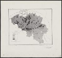
- Creator:
- United States. Office of Strategic Services
- Published / Created:
- 1942
- Call Number:
- 335eb 1942
- Container / Volume:
- BRBL_00087
- Image Count:
- 1
- Resource Type:
- Maps, Atlases & Globes
- Found in:
- Beinecke Rare Book and Manuscript Library > Belgium population density / compiled and drawn in Geography Division, O.S.S.
- Published / Created:
- [1904?]
- Call Number:
- 335 1904
- Container / Volume:
- BRBL_00086
- Image Count:
- 1
- Resource Type:
- Maps, Atlases & Globes
- Found in:
- Beinecke Rare Book and Manuscript Library > Carte Pour Cyclistes & Automobiles de la Belgique Section est.
- Creator:
- Établissement Géographique (Bruxelles)
Mols, L
Ongers, J
- Published / Created:
- [ca. 1855]
- Call Number:
- 335 1855
- Container / Volume:
- BRBL_00086
- Image Count:
- 1
- Resource Type:
- Maps, Atlases & Globes
- Found in:
- Beinecke Rare Book and Manuscript Library > Carte pittoresque des chemins de fer de la Belgique / Dessiné par L. Mols et gravé par J. Ongers.
- Published / Created:
- 1913
- Call Number:
- 335 1913
- Container / Volume:
- BRBL_00086
- Image Count:
- 1
- Resource Type:
- Maps, Atlases & Globes
- Found in:
- Beinecke Rare Book and Manuscript Library > Carte routière de la Belgique à l'usage des touristes, cyclistes et automobilistes / publiée sous la direction de Aug. Fourmanois Chef des Routes, des Cartes et des Itinéraires topographique du T.C.B.
- Published / Created:
- [1917?]
- Call Number:
- 335 Y93 1917
- Container / Volume:
- BRBL_00087
- Image Count:
- 1
- Resource Type:
- Maps, Atlases & Globes
- Found in:
- Beinecke Rare Book and Manuscript Library > Champ de bataille de l'Yser = The Yser battlefield.