
Search


Limit your search
- Public135
- cartographic135
- Bellin, Jacques Nicolas, 1703-1772, cartographer5
- L'Isle, Guillaume de, 1675-17265
- Chatelain, Henri Abraham4
- Bellin, Jacques Nicolas, 1703-17722
- Bonne, Rigobert, 1727-17942
- Bowen, Emanuel, d. 17672
- Evans, Lewis, 1700?-17562
- Lewis, Samuel, 1753 or 4-18222
- Lotter, Tobias Conrad, 1717-17772
- Robert Sayer and John Bennett (Firm)2
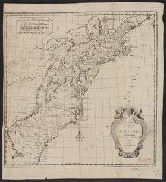
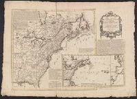
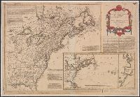
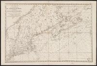
- British--America--Maps--Early works to 18003
- French--America--Maps--Early works to 18002
- British--America--Maps--Early works to 1800.1
- Cartographers--France--Paris1
- Chron.--17711
- Fur trade--Canada--Maps--Early works to 18001
- Harbors--Nova Scotia--Louisbourg--Maps--Early works to 18001
- Indians of North America--Maps--Early works to 18001
- Robert Laurie and James Whittle5
- Robert Laurie and James Whittle. New and elegant imperial sheet atlas5
- Chatelain, Henri Abraham. Atlas historique4
- Thorne Collection of Cartogaphy and Geography Stamp4
- Brown, Horace--Stamp3
- Homann Erben (Firm)3
- Lahontan, Louis Armand de Lom d'Arce, baron de, 1666-1715?3
- Bellin, Jacques Nicolas, 1703-1772. Atlas maritime2
- Carey, Mathew, 1760-18392
- Cóvens et Mortier. Atlas nouveau2