Skip to search
Skip to main content
Skip to first result
Search
You Searched For
Subject (Geographic)
Canada--Maps--Early works to 1800.
Search Results
Creator:
Published / Created:
1778
Call Number:
73 1778
Image Count:
1
Resource Type:
Maps, Atlases & Globes
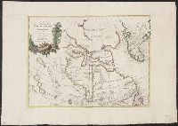
Description:
Appears in the Zatta's Atlante novissimo. 1779-85. v.4.
Publisher:
Presso Antonio Zatta,
Subject (Geographic):
Canada--Maps--Early works to 1800., Greenland--Maps--Early works to 1800., and Hudson Bay Region--Maps--Early works to 1800.
Subject (Name):
Giuliani, G., Pitteri, Giovanni Marco, 1702-1786., and Zatta, Antonio, active 1757-1797. Atlante Novissimo.
Found in:
Beinecke Rare Book and Manuscript Library > La Baja d'Hudson, terra di Labrador e Groenlandia con le isole adiacenti di nuova projezione / presso Antonio Zatta, G. Giuliani, inc., G. Pitteri, ser.
Creator:
Call Number:
73 1785
Image Count:
1
Resource Type:
Maps, Atlases & Globes
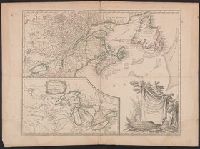
Alternative Title:
Partie de l'Amérique septent[rionale] qui comprend la Nouvelle France ou le Canada
Description:
Decorative title cartouche by Graux.
Subject (Geographic):
Canada--Maps--Early works to 1800., Great Lakes Region (North America)--Maps--Early works to 1800., and New France--Maps--Early works to 1800.
Subject (Name):
Robert de Vaugondy, Gilles, 1688-1766. Atlas universel.
Found in:
Beinecke Rare Book and Manuscript Library > Partie de l'Amérique septent? qui comprend la Nouvelle France ou le Canada / par le Sr. Robert de Vaugondy, géog? ordinaire du Roy ; Graux.
Creator:
Published / Created:
1755]
Call Number:
73 1755Kb
Image Count:
1
Resource Type:
Maps, Atlases & Globes
Alternative Title:
Partie de l'Amérique septent[rionale] qui comprend la Nouvelle France ou le Canada
Description:
"Avec privilege 1755."
Publisher:
s.n.,
Subject (Geographic):
Canada--Maps--Early works to 1800., Great Lakes Region (North America)--Maps--Early works to 1800., and New France--Maps--Early works to 1800.
Subject (Name):
George Washington's American Atlas., Haussard, Catherine, engraver., Morse, William Inglis,--b. 1874--Stamp., Robert de Vaugondy, Gilles, 1688-1766. Atlas universel., and Washington, George,--1732-1799--Ownership.
Found in:
Beinecke Rare Book and Manuscript Library > Partie de l'Amérique septent? qui comprend la Nouvelle France ou le Canada / par le Sr. Robert de Vaugondy, géog? ordinaire du Roy.
Creator:
Published / Created:
1755
Call Number:
731 1755B
Image Count:
1
Resource Type:
Maps, Atlases & Globes
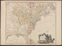
Abstract:
Shows Great Lakes region.
Description:
Covers the area from Lake Superior to Kaskaskia and from Delaware Bay to the Mississippi River.
Publisher:
[Homann Erben?],
Subject (Geographic):
Canada--Maps--Early works to 1800., Great Lakes Region (North America)--Maps--Early works to 1800., and New France--Maps--Early works to 1800.
Subject (Name):
Homann Erben (Firm)
Found in:
Beinecke Rare Book and Manuscript Library > Partie occidentale de la Nouvelle France ou du Canada / par Mr. Bellin, ingenieur du Roy et de la Marine, pour seruir à l'intelligence des affaires et de l'etat present en Amerique, communiquée au public par les Heritiers de Homanen l'an 1755.
Creator:
Published / Created:
1777]
Call Number:
755 1777E
Image Count:
1
Resource Type:
Maps, Atlases & Globes
Publisher:
William Faden,
Subject (Geographic):
Canada--Maps--Early works to 1800. and East (U.S.)--Maps--Early works to 1800.
Found in:
Beinecke Rare Book and Manuscript Library > The British Colonies in North America. Engraved by William Faden.