1. The countries of the Caribbean : including Mexico, Central America, the West Indies, and the Panama Creator: National Geographic Society (U.S.). Map Dept Published / Created: c1922 Call Number: 88cbf 1914 Container / Volume: BRBL_00648 Image Count: 1 Resource Type: Maps, Atlases & Globes Found in: Beinecke Rare Book and Manuscript Library > The countries of the Caribbean : including Mexico, Central America, the West Indies, and the Panama Canal / prepared especially for the National geographic magazine.
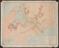
2. Map showing the Panama Canal and Canal Zone. Published / Created: 1913 Call Number: 899 1913 Container / Volume: BRBL_00660 Image Count: 1 Resource Type: Maps, Atlases & Globes Found in: Beinecke Rare Book and Manuscript Library > Map showing the Panama Canal and Canal Zone.
3. Map of the Canal Zone and vicinity / compiled under the direction of O.E. Malsburgy, Section of Creator: Canal Zone Published / Created: [1927] Call Number: 899 1927 Container / Volume: BRBL_00660 Image Count: 1 Resource Type: Maps, Atlases & Globes Found in: Beinecke Rare Book and Manuscript Library > Map of the Canal Zone and vicinity / compiled under the direction of O.E. Malsburgy, Section of Surveys.
4. Map showing location of Panama Canal : as recommended by the Isthmian Canal Commission of 1899-1902 Creator: National Geographic Society (U.S.) Published / Created: 1905 Call Number: 899 1905 Container / Volume: BRBL_00660 Image Count: 1 Resource Type: Maps, Atlases & Globes Found in: Beinecke Rare Book and Manuscript Library > Map showing location of Panama Canal : as recommended by the Isthmian Canal Commission of 1899-1902 / supplement to the National Geographic Magazine.