Search
You Searched For
Search Results
- Published / Created:
- 1920
- Call Number:
- 766fb 1920
- Container / Volume:
- BRBL_00475
- Image Count:
- 1
- Resource Type:
- Maps, Atlases & Globes
- Found in:
- Beinecke Rare Book and Manuscript Library > Connecticut.
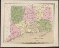
- Published / Created:
- 1838
- Call Number:
- 766 1838
- Container / Volume:
- BRBL_00466
- Image Count:
- 1
- Resource Type:
- Maps, Atlases & Globes
- Found in:
- Beinecke Rare Book and Manuscript Library > Connecticut.
- Published / Created:
- 1842
- Call Number:
- 766 1842A
- Container / Volume:
- BRBL_00466
- Image Count:
- 1
- Resource Type:
- Maps, Atlases & Globes
- Found in:
- Beinecke Rare Book and Manuscript Library > Connecticut.
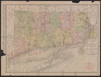
- Published / Created:
- [c1910?]
- Call Number:
- 766 1910
- Container / Volume:
- BRBL_00467
- Image Count:
- 1
- Resource Type:
- Maps, Atlases & Globes
- Found in:
- Beinecke Rare Book and Manuscript Library > Connecticut.
- Published / Created:
- [c1910?].
- Call Number:
- 766 1910R
- Container / Volume:
- BRBL_00467
- Image Count:
- 2
- Resource Type:
- Maps, Atlases & Globes
- Found in:
- Beinecke Rare Book and Manuscript Library > Connecticut.
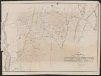
- Published / Created:
- 1853
- Call Number:
- 766gme 1853
- Container / Volume:
- BRBL_00475A
- Image Count:
- 1
- Resource Type:
- Maps, Atlases & Globes
- Found in:
- Beinecke Rare Book and Manuscript Library > General map accompanying the report on surveys : For extension of the Hartford, Providence & Fishkill Rail Road.
- Call Number:
- 766 1827
- Container / Volume:
- BRBL_00465
- Image Count:
- 1
- Resource Type:
- Maps, Atlases & Globes
- Found in:
- Beinecke Rare Book and Manuscript Library > Geographical, statistical and historical map of Connecticut.
- Creator:
- C.S. Hammond & Company
- Published / Created:
- c1916.
- Call Number:
- 766gmb 1916H
- Container / Volume:
- BRBL_00475
- Image Count:
- 1
- Resource Type:
- Maps, Atlases & Globes
- Found in:
- Beinecke Rare Book and Manuscript Library > Hammond's new road map of Connecticut (Eastern part) / based on the surveys of the United States Geological Survey, United States Coast and Geodetic Survey and the various local surveys, revised and corrected ... C.S. Hammond & Company.
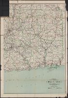
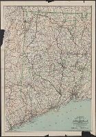
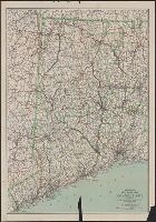
- Creator:
- C.S. Hammond & Company
- Published / Created:
- 1916
- Call Number:
- 766gmb 1916H
- Container / Volume:
- BRBL_00475
- Image Count:
- 1
- Resource Type:
- Maps, Atlases & Globes
- Found in:
- Beinecke Rare Book and Manuscript Library > Hammond's new road map of Connecticut (Western part) / based on the surveys of the United States Geological Survey, United States Coast and Geodetic Survey and the various local surveys, revised and corrected ... C.S. Hammond & Company.