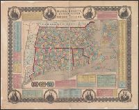
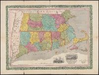
"Entered according to act of Congress in the year 1855 by Ensign, Bridgman & Fanning ...", Border includes 8 portraits (J, Hand colored by township. State and county borders outlined., Inset: "Boston.", and Prime meridian: Washington (top) and Greenwich (bottom).
Publisher:
Ensign, Bridgman & Fanning,
Subject (Geographic):
Boston (Mass.)--Maps, Connecticut--Maps, Massachusetts--Maps, and Rhode Island--Maps
Subject (Topic):
Cities and towns--Connecticut--Maps, Cities and towns--Massachusetts--Maps, and Cities and towns--Rhode Island--Maps
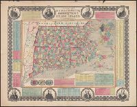
"Entered according to act of Congress in the year 1855 by Ensign, Bridgman & Fanning ..." and Border includes 8 portraits (John Hancock, Cotton Mather, Daniel Webster, Roger Williams, Gov. Trumbull, Timothy Dwight, O. Ellsworth, and Gen. Greene), 3 vignettes,
Publisher:
Ensign, Bridgman & Fanning,
Subject (Geographic):
Boston (Mass.)--Maps, Connecticut--Maps, Massachusetts--Maps, and Rhode Island--Maps
Subject (Topic):
Cities and towns--Connecticut--Maps, Cities and towns--Massachusetts--Maps, and Cities and towns--Rhode Island--Maps
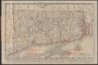
Includes population chart and index to ownership of electric railways., Inset: Map showing the lines of communication between New York, Boston and the West., and Relief shown by shading and spot heights.
Horace Thayer & Co.'s map of Mass., Conn. & R.I. and Railroad & township map of Massachusetts, Connecticut and Rhode Island
Description:
Borders of counties in red, yellow, green and blue; borders of Connecticut and Rhode Island in red., Cover title: Horace Thayer & Co.'s map of Mass., Conn. & R.I., In purplish black cloth covered folder with gold title within decorative border., and Includes vig
Publisher:
Thayer, Bridgman & Fanning,
Subject (Geographic):
Connecticut--Maps, Massachusetts--Maps, New England--Maps, New York (State)--Maps, and Rhode Island--Maps