Search
You Searched For
Search Results
- Published / Created:
- [1801?]
- Call Number:
- 755 1801
- Container / Volume:
- BRBL_00437
- Image Count:
- 1
- Resource Type:
- Maps, Atlases & Globes
- Found in:
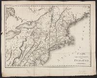
- Beinecke Rare Book and Manuscript Library > Carte de la Partie Septentrionale des Etats-Unis. Gravé par Tardieu.
- Published / Created:
- [1800?]
- Call Number:
- 755 1800F
- Container / Volume:
- BRBL_00437
- Image Count:
- 1
- Resource Type:
- Maps, Atlases & Globes
- Found in:
- Beinecke Rare Book and Manuscript Library > Carte de la Partie Septentrionale des Etats-Unis. Gravé par Tardieu.
- Published / Created:
- [1800?]
- Call Number:
- 755 1800F
- Container / Volume:
- BRBL_00437
- Image Count:
- 1
- Resource Type:
- Maps, Atlases & Globes
- Found in:
- Beinecke Rare Book and Manuscript Library > Carte de la Partie Septentrionale des Etats-Unis. Gravé par Tardieu.
- Published / Created:
- 1908
- Call Number:
- 754gme 1908
- Container / Volume:
- BRBL_00420
- Image Count:
- 1
- Resource Type:
- Maps, Atlases & Globes
- Found in:
- Beinecke Rare Book and Manuscript Library > Erie Railroad with branches and connections / Office of Chief Engineer.
- Published / Created:
- 1844
- Call Number:
- 755 1844
- Container / Volume:
- BRBL_00441
- Image Count:
- 1
- Resource Type:
- Maps, Atlases & Globes
- Found in:
- Beinecke Rare Book and Manuscript Library > Guide through Ohio, Michigan, Indiana, Illinois, Missouri, Wisconsin & Iowa by J. Calvin Smith ...
- Published / Created:
- [1843?]
- Call Number:
- 755 1843A
- Container / Volume:
- BRBL_00441
- Image Count:
- 1
- Resource Type:
- Maps, Atlases & Globes
- Found in:
- Beinecke Rare Book and Manuscript Library > Map exhibiting the country between Lakes Michigan and Erie and the contested boundary lines.
- Published / Created:
- 1833
- Call Number:
- 755 1833
- Container / Volume:
- BRBL_00440
- Image Count:
- 1
- Resource Type:
- Maps, Atlases & Globes
- Found in:
- Beinecke Rare Book and Manuscript Library > Map of Louisiana, Mississippi and Alabama, constructed from the latest authorities.
- Published / Created:
- [1820?]
- Call Number:
- 755 1820
- Container / Volume:
- BRBL_00439
- Image Count:
- 1
- Resource Type:
- Maps, Atlases & Globes
- Found in:
- Beinecke Rare Book and Manuscript Library > Map of North and South Carolina and Georgia, constructed from the latest authorities.
- Published / Created:
- 1826
- Call Number:
- 755gma 1826
- Container / Volume:
- BRBL_00442
- Image Count:
- 1
- Resource Type:
- Maps, Atlases & Globes
- Found in:
- Beinecke Rare Book and Manuscript Library > Map of the Country between Washington & Pittsburg referring to the contemplated Chesapeake & Ohio Canal and its general route and profile. Oct. 1826. Drawn by Lieut. Farley, U.S.A. Etched by Wm. Harrison, Georgetown, D.C., Lettered by D.R. Harrison.
- Published / Created:
- 1835
- Call Number:
- 755 1835B
- Container / Volume:
- BRBL_00440
- Image Count:
- 1
- Resource Type:
- Maps, Atlases & Globes
- Found in:
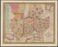
- Beinecke Rare Book and Manuscript Library > Map of the States of Ohio, Indiana, and Illinois with the settled part of Michigan.