Inset: North Sea and English Channel Area -- Map of the Balkan Area. and On verso: The World -- Rand McNally Polar Map of the World -- Map of Asiatic and Southwest Pacific War Area.
Inset: North Sea and English Channel Area -- Map of the Balkan Area. and On verso: Rand McNally popular map of the World -- Rand McNally Polar Map of the World -- Map of the Western Pacific.
Europe air mileage distances., Far East., Northern Scandinavia., South England and adjacent continental area., World., and World-wide news map
Description:
Insets: Northern Scandinavia -- South England and Adjacent Continental Area. and On verso: The World -- Europe Air Mileage Distances -- Map of the Far East -- Map of the Balkans.
United States. Office of Strategic Services. Research and Analysis Branch
Published / Created:
1944
Call Number:
30gf 1944
Container / Volume:
BRBL_00037B
Image Count:
1
Resource Type:
Maps, Atlases & Globes
Description:
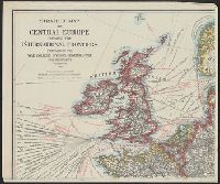
"Map no. 5531, 14 November, 1944.", Includes index of major coal fields and reliability diagram., and Shows iron mining districts, steel centers and coal fields.
Publisher:
R & A, OSS,
Subject (Geographic):
Europe--Maps
Subject (Topic):
Coal--Europe--Maps, Iron mines and mining--Europe--Maps, and Steel--Europe--Maps
Bontz, Geo. F United States. War Dept. General Staff. War College Division Williams, Arch. B
Published / Created:
1915
Call Number:
304fab 1915
Container / Volume:
BRBL_00034B
Image Count:
4
Resource Type:
Maps, Atlases & Globes
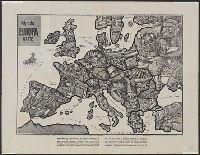
Description:
Relief shown by hachures., Shows Europe from Ireland and Portugal on the west, Moscow on the east, Trondheim, Norway on the north, and Crete on the south., and Shows steamship routes with estimated travel times, submarine cables, radio stations, naval bases, an