Search
You Searched For
Search Results
- Creator:
- Seutter, Matthaeus, 1678-1756
- Published / Created:
- [1725?]
- Call Number:
- BrSides Double Folio 2019 48
- Image Count:
- 1
- Resource Type:
- Maps, Atlases & Globes
- Found in:
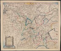
- Beinecke Rare Book and Manuscript Library > Societas Iesu Germana sive Assistentia Germaniae : quae complectitur X. provincias ... / excud. Matth. Seutt., S.C.M.G., Aug. ; Georg Mattheus Seutter junior sculps.
- Creator:
- Münster, Sebastian, 1489-1552
Münster, Sebastian, 1489-1552. Geographia universalis
Petri, Heinrich, 1508-1579
- Published / Created:
- 1540]
- Call Number:
- 30 1545
- Container / Volume:
- BRBL_00029
- Image Count:
- 2
- Resource Type:
- Maps, Atlases & Globes
- Found in:
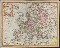
- Beinecke Rare Book and Manuscript Library > Europa prima nova tabula.
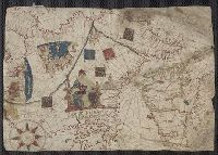
- Call Number:
- 32cea 1550
- Container / Volume:
- BRBL_00701
- Image Count:
- 2
- Resource Type:
- Maps, Atlases & Globes
- Found in:
- Beinecke Rare Book and Manuscript Library > [Section of a portolan chart spanning Great Britain in the west to the Adriatic Sea in the east.]
- Creator:
- Münster, Sebastian, 1489-1552
- Published / Created:
- 1544]
- Call Number:
- 30 1544
- Container / Volume:
- BRBL_00732
- Image Count:
- 2
- Resource Type:
- Maps, Atlases & Globes
- Found in:
- Beinecke Rare Book and Manuscript Library > Europa, das ein Drittheil der Erden nach Gelegenheit unsern Zeiten.
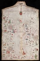
- Published / Created:
- 1590
- Call Number:
- 49cea 1590
- Image Count:
- 2
- Resource Type:
- Maps, Atlases & Globes
- Found in:
- Beinecke Rare Book and Manuscript Library > [Portolan chart of the Mediterranean Sea and Europe].
- Published / Created:
- 1640
- Call Number:
- 30 1640
- Container / Volume:
- BRBL_00029
- Image Count:
- 2
- Resource Type:
- Maps, Atlases & Globes
- Found in:
- Beinecke Rare Book and Manuscript Library > Carte de l'Europe - corrigée et Augmenteè dessus toutes les aultres cy devant faictes par P. Bertius Cosmographe et Bertius du Roy.
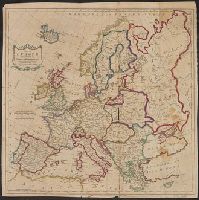
- Published / Created:
- 1815
- Call Number:
- 30hc 1815
- Container / Volume:
- BRBL_00038
- Image Count:
- 2
- Resource Type:
- Maps, Atlases & Globes
- Found in:
- Beinecke Rare Book and Manuscript Library > Europe (1715-1815) illustrating the wars of the French Revolution and Napoleon's wars.
- Creator:
- Kitchin, Thomas, d. 1784
- Published / Created:
- 1783
- Call Number:
- 30 1783
- Container / Volume:
- BRBL_00029
- Image Count:
- 1
- Resource Type:
- Maps, Atlases & Globes
- Found in:
- Beinecke Rare Book and Manuscript Library > Map of Europe divided into its empires, kingdoms, &c. / by Thos. Kitchin ...
- Published / Created:
- 1651
- Call Number:
- 30 1651
- Container / Volume:
- BRBL_00029
- Image Count:
- 1
- Resource Type:
- Maps, Atlases & Globes
- Found in:
- Beinecke Rare Book and Manuscript Library > [Map of Europe] Carta Noua accurata del passagio et strada dalli Paesi Bassi per via de Allemagna per Italia et per via di paesi Sinzeri a Geneva Lione et Roma.
- Creator:
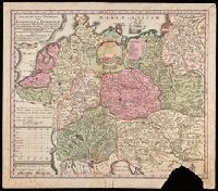
- L'Isle, Guillaume de, 1675-1726
Lotter, Tobias Conrad, 1717-1777
- Published / Created:
- 176-?]
- Call Number:
- 30 1720A
- Container / Volume:
- BRBL_00029
- Image Count:
- 1
- Resource Type:
- Maps, Atlases & Globes
- Found in:
- Beinecke Rare Book and Manuscript Library > Europa [cartographic material] : delineata juxta observationes excellorum virorum Academiae regalis scientiarum et nonnullorum alioru[m] et juxta recentis[si]mas annotationes / per G. de L'Isle, geographum Parisiis prostat nunc in officina ; Tobiae Conrad