Search
You Searched For
Search Results
- Creator:
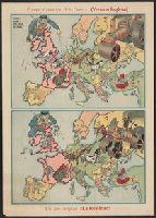
- Horký, Karel, 1879-1965
Lenhard, J
- Published / Created:
- c1917.
- Call Number:
- 30 1917B
- Container / Volume:
- BRBL_00032A
- Image Count:
- 1
- Resource Type:
- Maps, Atlases & Globes
- Found in:
- Beinecke Rare Book and Manuscript Library > 1914--1915--1916--1917--?? / drawn by J. Lenhard.
- Creator:
- Hewerdine, Matt
Rose, Fredk. W. (Frederick W.)
- Published / Created:
- c1899.
- Call Number:
- 30an 1899A
- Container / Volume:
- BRBL_00037A
- Image Count:
- 2
- Resource Type:
- Maps, Atlases & Globes
- Found in:
- Beinecke Rare Book and Manuscript Library > Angling in troubled waters [cartographic material] : a serio-comic map of Europe / by Fred. W. Rose ; Matt. Hewerdine, from design by Fred. W. Rose.
- Creator:
- Hewerdine, Matt
Rose, Fredk. W. (Frederick W.)
- Published / Created:
- c1899.
- Call Number:
- 30an 1899
- Container / Volume:
- BRBL_00037A
- Image Count:
- 1
- Resource Type:
- Maps, Atlases & Globes
- Found in:
- Beinecke Rare Book and Manuscript Library > Angling in troubled waters [cartographic material] : a serio-comic map of Europe / by Fred. W. Rose ; Matt. Hewerdine, from design by Fred. W. Rose.
- Creator:
- G.W. Bacon & Co
- Published / Created:
- [ca. 1917]
- Call Number:
- 307hc 1917
- Container / Volume:
- BRBL_00036A
- Image Count:
- 2
- Resource Type:
- Maps, Atlases & Globes
- Found in:
- Beinecke Rare Book and Manuscript Library > Bacon's map of the seat of war in the North Sea, Belgium and eastern France.
- Creator:
- E. B
- Published / Created:
- 1915?]
- Call Number:
- 30 1915F
- Container / Volume:
- BRBL_00032A
- Image Count:
- 1
- Resource Type:
- Maps, Atlases & Globes
- Found in:
- Beinecke Rare Book and Manuscript Library > Europa al principio de la guerra ; Un año despues !!la realidad!! / [por] EB.
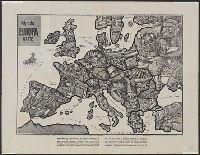
- Published / Created:
- [1870]
- Call Number:
- 30an 1870E
- Container / Volume:
- BRBL_00037
- Image Count:
- 1
- Resource Type:
- Maps, Atlases & Globes
- Found in:
- Beinecke Rare Book and Manuscript Library > Humoristische Kaart van Europa 1870.
- Creator:
- Hewerdine, Matt
Rose, Fredk. W. (Frederick W.)
- Published / Created:
- [1900]
- Call Number:
- 30 1900
- Container / Volume:
- BRBL_00032
- Image Count:
- 1
- Resource Type:
- Maps, Atlases & Globes
- Found in:
- Beinecke Rare Book and Manuscript Library > John Bull and his friends : a serio-comic map of Europe ... 1900 / by Fred. W. Rose ; Matt. B. Hewerdine from a sketch by Fred. W. Rose.
- Creator:
- Hadol, Paul, 1835-1875
- Published / Created:
- [1870]
- Call Number:
- 30 1870C
- Container / Volume:
- BRBL_00032
- Image Count:
- 1
- Resource Type:
- Maps, Atlases & Globes
- Found in:
- Beinecke Rare Book and Manuscript Library > Karte von Europa im Jahre 1870 nach einem französischen Holzschnitte / dressée par Hadol.
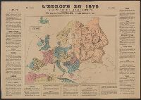
- Creator:
- Barrey, Yves L
- Published / Created:
- 1876]
- Call Number:
- 30 1876
- Container / Volume:
- BRBL_00032
- Image Count:
- 1
- Resource Type:
- Maps, Atlases & Globes
- Found in:
- Beinecke Rare Book and Manuscript Library > L'Europe en 1876 a la portée des grands esprits / Yves L. Barrey, sc.
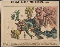
- Creator:
- Hadol, Paul, 1835-1875. Carte drôlatique d'Europe pour 1870
- Published / Created:
- [1870]
- Call Number:
- 30 1870D
- Container / Volume:
- BRBL_00032
- Image Count:
- 1
- Resource Type:
- Maps, Atlases & Globes
- Found in:
- Beinecke Rare Book and Manuscript Library > Nieuwe kaart van Europa 1870.
- Creator:
- Zimmermann, E
- Published / Created:
- [1914]
- Call Number:
- 30an 1914C
- Container / Volume:
- BRBL_00037A
- Image Count:
- 1
- Resource Type:
- Maps, Atlases & Globes
- Found in:
- Beinecke Rare Book and Manuscript Library > Satyrische Europa Karte, Weltkrieg 1914 / Zeichnung u. Entwurf, E. Zimmermann.