Skip to search
Skip to main content
Skip to first result
Search
You Searched For
Subject (Geographic)
Florida--Maps
Search Results
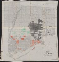
Published / Created:
1848
Call Number:
792fcm 1848
Container / Volume:
BRBL_00519
Image Count:
1
Resource Type:
Maps, Atlases & Globes
Publisher:
Surveyor General's Office,
Subject (Geographic):
Florida--Maps
Found in:
Beinecke Rare Book and Manuscript Library > A Plat Exhibiting the State of the Surveys in the State of Florida with references.
Published / Created:
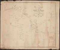
1823
Call Number:
792cea 1823
Container / Volume:
BRBL_00519
Image Count:
1
Resource Type:
Maps, Atlases & Globes
Publisher:
Richard Pattern,
Subject (Geographic):
Florida--Maps
Found in:
Beinecke Rare Book and Manuscript Library > A particular Chart of the coasts of West Florida Louisiana Mississippi & Alabama ...
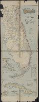
Published / Created:
1911
Call Number:
792gme 1911
Container / Volume:
BRBL_00520
Image Count:
2
Resource Type:
Maps, Atlases & Globes
Description:
Depths shown by soundings and bathymetric isolines.
Publisher:
Matthews-Northrup Works,
Subject (Geographic):
Florida--Maps
Subject (Name):
Florida East Coast Railway and Matthews-Northrup Works
Found in:
Beinecke Rare Book and Manuscript Library > Florida East Coast Railway / Jacksonville via St. Augustine, Ormond, Palm Beach and Miami to Key West and Havana.
Published / Created:
[1880?]
Call Number:
792e 1880A
Container / Volume:
BRBL_00519
Image Count:
2
Resource Type:
Maps, Atlases & Globes
Publisher:
Land & Improvement Co.,
Subject (Geographic):
Florida--Maps
Found in:
Beinecke Rare Book and Manuscript Library > Florida land & improvement company. Hamilton Disston's purchase, 4,000,000 acres, showing area in which lands have been selected.
Creator:
Published / Created:
c1911.
Call Number:
792 1911C
Container / Volume:
BRBL_00519
Image Count:
1
Resource Type:
Maps, Atlases & Globes
Alternative Title:
Rand, McNally & Co.'s New business atlas map of Florida
Description:
Includes table for identifying marked Florida railroads.
Publisher:
Rand, McNally & Co.,
Subject (Geographic):
Florida--Maps
Subject (Topic):
Railroads--Florida--Maps
Found in:
Beinecke Rare Book and Manuscript Library > Florida.
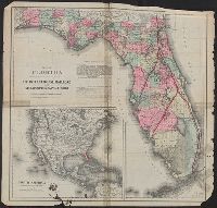
Creator:
Published / Created:
c1884.
Call Number:
792gm 1883
Container / Volume:
BRBL_00520
Image Count:
1
Resource Type:
Maps, Atlases & Globes
Description:
Imperfect: ink staining.
Publisher:
G.W. and C.B. Colton & Co.,
Subject (Geographic):
Florida--Maps
Subject (Name):
Bloxham, William Dunnington, 1835-1911, Gordon, John Brown, 1832-1904, International Railroad and Steamship Company of Florida, and International Railroad and Steamship Company of Florida--Maps
Subject (Topic):
Coastwise shipping--Florida--Maps and Railroads--Florida--Maps
Found in:
Beinecke Rare Book and Manuscript Library > Map of Florida : showing the main line and branches of the International Railroad and Steamship Company of Florida.
Published / Created:
1888
Call Number:
792 1888
Container / Volume:
BRBL_00518
Image Count:
1
Resource Type:
Maps, Atlases & Globes
Description:
Map by Rand McNally & Co.
Publisher:
Knickerbocker Guide Co.,
Subject (Geographic):
Florida--Maps
Found in:
Beinecke Rare Book and Manuscript Library > Map of Florida, published with the traveler's ready reference guide.
Published / Created:
c1900.
Call Number:
792 1900
Container / Volume:
BRBL_00519
Image Count:
1
Resource Type:
Maps, Atlases & Globes
Description:
Hand col.
Publisher:
Crawford & Reynolds
Subject (Geographic):
Florida--Maps
Subject (Name):
Crawford & Reynolds
Subject (Topic):
Land grants--Florida--Maps
Found in:
Beinecke Rare Book and Manuscript Library > Map of lands in middle Florida known as Forbes Purchase.
Creator:
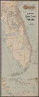
Published / Created:
[1906?]
Call Number:
792 1906
Container / Volume:
BRBL_00519
Image Count:
1
Resource Type:
Maps, Atlases & Globes
Alternative Title:
Florida East Coast Railway
Description:
Insets: Map of Florida and the West Indies -- Bahama Islands -- Map of Cuba showing its proximity to Key West, Florida, the southern terminus of the Florida East Coast Railway ... [with additional inset of Havana].
Publisher:
Matthews-Northrup Works,
Subject (Geographic):
Cuba--Maps and Florida--Maps
Subject (Name):
Florida East Coast Railway--Maps
Subject (Topic):
Railroads--Florida--Maps
Found in:
Beinecke Rare Book and Manuscript Library > Map of the peninsula of Florida and adjacent islands, Florida East Coast Railway.
Published / Created:
[1895?]
Call Number:
792gme 1895
Container / Volume:
BRBL_00520
Image Count:
1
Resource Type:
Maps, Atlases & Globes
Description:
Imperfect.
Publisher:
Florida East Coast Railway ; and Matthews Northrup Co. [printers],
Subject (Geographic):
Florida--Maps
Subject (Name):
Matthews-Northrup Company
Subject (Topic):
Railroads--Florida--Maps
Found in:
Beinecke Rare Book and Manuscript Library > Map of the peninsula of Florida and adjacent islands.