Search
You Searched For
Search Results
- Published / Created:
- 1828
- Call Number:
- 38GMD 1828
- Container / Volume:
- BRBL_00171
- Image Count:
- 1
- Resource Type:
- Maps, Atlases & Globes
- Found in:
- Beinecke Rare Book and Manuscript Library > A Physical and Topographical map of France ... the post Roads & Relays ... inland Navigation &c. Pickett Sculp. J. Smith Delin.
- Published / Created:
- 1806
- Call Number:
- 38 1806
- Container / Volume:
- BRBL_00154
- Image Count:
- 1
- Resource Type:
- Maps, Atlases & Globes
- Found in:
- Beinecke Rare Book and Manuscript Library > A new map of France ... division into Provinces as previous to the Revolution ... by John Cary, Engraver.
- Published / Created:
- 1811
- Call Number:
- 38 1811
- Container / Volume:
- BRBL_00154
- Image Count:
- 1
- Resource Type:
- Maps, Atlases & Globes
- Found in:
- Beinecke Rare Book and Manuscript Library > A new map of France ... divison into provinces as previous to the revolution ... John Cary, Engraver.
- Published / Created:
- 1799
- Call Number:
- 38 1799A
- Container / Volume:
- BRBL_00154
- Image Count:
- 1
- Resource Type:
- Maps, Atlases & Globes
- Found in:
- Beinecke Rare Book and Manuscript Library > A new map of France divided into departments as decreed by the National Assembly, 1790 ... John Cary, Engraver.
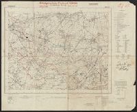
- Creator:
- Germany. Heer. Generalstab
- Published / Created:
- 1940
- Call Number:
- 11hd 1942D-54
- Container / Volume:
- BRBL_00010ZE
- Image Count:
- 1
- Resource Type:
- Maps, Atlases & Globes
- Found in:
- Beinecke Rare Book and Manuscript Library > Befestigungskarte Frankreich 1:25000 : St. Amand, Nr. 1-2, XXVI-5/1-2.
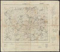
- Creator:
- Great Britain. War Office. General Staff. Geographical Section
- Published / Created:
- 1910
- Call Number:
- 335 1910
- Container / Volume:
- BRBL_00086
- Image Count:
- 1
- Resource Type:
- Maps, Atlases & Globes
- Found in:
- Beinecke Rare Book and Manuscript Library > Belgium and the north east of France G.S.G.S. 2517 [cartographic material].
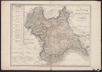
- Published / Created:
- [1844?]
- Call Number:
- 401 1844
- Container / Volume:
- BRBL_00233
- Image Count:
- 1
- Resource Type:
- Maps, Atlases & Globes
- Found in:
- Beinecke Rare Book and Manuscript Library > Carta moderna degli State Sarde di Terraferma [cartographic material] / V. Stanghi e G. Maina Inc. ; G Pozzi scrisse.
- Published / Created:
- 1859
- Call Number:
- 401 1859
- Container / Volume:
- BRBL_00233
- Image Count:
- 1
- Resource Type:
- Maps, Atlases & Globes
- Found in:
- Beinecke Rare Book and Manuscript Library > Carta politico-amministativa degli State Sarde di Terraferma / V. Stanghi e G. Maina Inc. ; G Pozzi scrisse.
- Published / Created:
- 1855?]
- Call Number:
- 38 1855A
- Container / Volume:
- BRBL_00154
- Image Count:
- 1
- Resource Type:
- Maps, Atlases & Globes
- Found in:
- Beinecke Rare Book and Manuscript Library > Carte Générale des Routes de France : et d'une partie des États limitrophes... / Dressée par A.R. Fremin, Géographe.
- Published / Created:
- [1898?]
- Call Number:
- 38 1898
- Container / Volume:
- BRBL_00155
- Image Count:
- 1
- Resource Type:
- Maps, Atlases & Globes
- Found in:
- Beinecke Rare Book and Manuscript Library > Carte Physique, Politique et Administrative de la France, avec le tracé des Chemins de Fer, sous la direction de L. Bonnefont ... Dressée par A. Vuillemin.
- Published / Created:
- 191-?]
- Call Number:
- 11hcf 1919D-44
- Container / Volume:
- BRBL_00010X
- Image Count:
- 1
- Resource Type:
- Maps, Atlases & Globes
- Found in:
- Beinecke Rare Book and Manuscript Library > Carte Routière Kilométrique du Morbihan : avec indication des principales pentes.
- Published / Created:
- 1820
- Call Number:
- 38 1820
- Container / Volume:
- BRBL_00154
- Image Count:
- 1
- Resource Type:
- Maps, Atlases & Globes
- Found in:
- Beinecke Rare Book and Manuscript Library > Carte de France par A.H. Brue ... Paris. Gravée sous la direction de l'auteur.
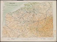
- Creator:
- France. Ministère de l'intérieur
- Published / Created:
- [1891?-1910?]
- Call Number:
- 3814 1905
- Container / Volume:
- BRBL_00174
- Image Count:
- 1
- Resource Type:
- Maps, Atlases & Globes
- Found in:
- Beinecke Rare Book and Manuscript Library > Carte de la France [cartographic material] / dressée par ordre du Ministre de l'intérieur ; gravée et imprimée par Erhard.
- Published / Created:
- 1918?]
- Call Number:
- 11hc 1918
- Container / Volume:
- BRBL_00010E
- Image Count:
- 3
- Resource Type:
- Maps, Atlases & Globes
- Found in:
- Beinecke Rare Book and Manuscript Library > Carte de la France et des Frontieres a 1:200,000.
- Published / Created:
- [1801]
- Call Number:
- 38hc 1801
- Container / Volume:
- BRBL_00172
- Image Count:
- 1
- Resource Type:
- Maps, Atlases & Globes
- Found in:
- Beinecke Rare Book and Manuscript Library > Carte des Routes d'Etapes de la République Francaise Dressée au Dépôt Général de la Guerre. en l'An 1X (1801) Gravér par P.F. Tardieu. Ecrite par L. Aubert.
- Published / Created:
- [1871?]
- Call Number:
- 38hc 1871
- Container / Volume:
- BRBL_00172
- Image Count:
- 1
- Resource Type:
- Maps, Atlases & Globes
- Found in:
- Beinecke Rare Book and Manuscript Library > Carte des frontières : France et Prusse / J. Roussel, graveur.
- Creator:
- Taride, A
- Published / Created:
- 191-
- Call Number:
- 383 1917
- Container / Volume:
- BRBL_00177
- Image Count:
- 1
- Resource Type:
- Maps, Atlases & Globes
- Found in:
- Beinecke Rare Book and Manuscript Library > Carte du front Français [cartographic material] / A. Taride, editeur.
- Published / Created:
- 1811]
- Call Number:
- 38 1811A
- Container / Volume:
- BRBL_00154
- Image Count:
- 1
- Resource Type:
- Maps, Atlases & Globes
- Found in:
- Beinecke Rare Book and Manuscript Library > Carte e l'empire Francais et du royaume d'Italie... / par che. Picquet, 1811.