Search
You Searched For
Search Results
- Published / Created:
- 1802
- Call Number:
- 907cea 1802
- Container / Volume:
- BRBL_00668
- Image Count:
- 1
- Resource Type:
- Maps, Atlases & Globes
- Description:
- From Wittle, J. and Laurie, R.H., The West India Atlas, London, 1818.
- Publisher:
- Laurie & Wittle,
- Subject (Geographic):
- Guyana--Maps
- Found in:
- Beinecke Rare Book and Manuscript Library > A new chart of Surinam river (and the coast approaching it) to Paramarabo. Accompanied with sailing directions - views of the land, &c. - 1801.
- Creator:
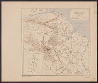
- Royal Geographical Society (Great Britain)
- Published / Created:
- 1911
- Call Number:
- 9065 1911
- Container / Volume:
- BRBL_00667
- Image Count:
- 1
- Resource Type:
- Maps, Atlases & Globes
- Alternative Title:
- Geographical Journal.
- Description:
- From: The Geographical Journal, 1911.
- Publisher:
- Royal Geographical Society,
- Subject (Geographic):
- Guyana--Maps
- Found in:
- Beinecke Rare Book and Manuscript Library > British Guiana to illustrate a paper by J.A.J. De Villiers.
- Creator:
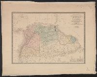
- Brué, Adrien Hubert, d. 1832
- Published / Created:
- [1875]
- Call Number:
- 90 1850A
- Container / Volume:
- BRBL_00663
- Image Count:
- 1
- Resource Type:
- Maps, Atlases & Globes
- Description:
- Above neat line at left: Atlas universel en 67 feuilles no. 65.
- Publisher:
- Ch. Delagrave, 58 rue des Ecoles,
- Subject (Geographic):
- Amazon River--Maps, Colombia--Maps, Ecuador--Maps, Guyana--Maps, and Venezuela--Maps
- Subject (Name):
- Levasseur, Émile, 1828-1911
- Found in:
- Beinecke Rare Book and Manuscript Library > Carte des républiques de l'Equateur de Colombie de Venezuela et des Guyanes Française, Hollandaise et Anglaise / dressée par A. Brué, géographe.
- Published / Created:
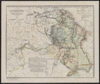
- 1846
- Call Number:
- 9065 1846
- Container / Volume:
- BRBL_00667
- Image Count:
- 1
- Resource Type:
- Maps, Atlases & Globes
- Description:
- Reproduced by the Heliotype Printing Co., Boston from the original in "Reisen in British-Guiana in den Jaren 1840-44.
- Subject (Geographic):
- Guyana--Maps
- Found in:
- Beinecke Rare Book and Manuscript Library > Karte von British - Guyana nebst demQuelllande des Prima (Rio Branco und Orinoco. Vornehmlich nach den in den Jahren 1835-44 veranstalteten in Colonial-Office zu London befindliche Aufnahmen des Sir Robert H. Schomburgk, Berlin, 1846.