Search
You Searched For
Search Results
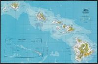
- Creator:
- National Geographic Society (U.S.). Cartographic Division
- Published / Created:
- 1978
- Call Number:
- 231 1978
- Container / Volume:
- BRBL_00020
- Image Count:
- 2
- Resource Type:
- Maps, Atlases & Globes
- Found in:
- Beinecke Rare Book and Manuscript Library > Close-up: U.S.A., Hawaii / produced by the Cartographic Division, National Geographic Society.
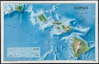
- Creator:
- National Geographic Society (U.S.). Cartographic Division
- Published / Created:
- c1995.
- Call Number:
- 231 1995
- Container / Volume:
- BRBL_00020
- Image Count:
- 2
- Resource Type:
- Maps, Atlases & Globes
- Found in:
- Beinecke Rare Book and Manuscript Library > Hawaii / produced by the Cartographic Division, National Geographic Society.
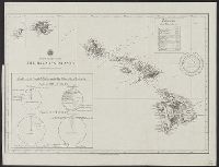
- Published / Created:
- 1841
- Call Number:
- 231 1841
- Container / Volume:
- BRBL_00020
- Image Count:
- 1
- Resource Type:
- Maps, Atlases & Globes
- Found in:
- Beinecke Rare Book and Manuscript Library > Map of Hawaiian Group or Sandwich Islands by the U.S. Ex.Ex. 1841. Engraved by Sherman & Smith, NY.
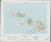
- Creator:
- Geological Survey (U.S.)
United States. Army Map Service
- Published / Created:
- 1974
- Call Number:
- 234 1974
- Container / Volume:
- BRBL_00020
- Image Count:
- 1
- Resource Type:
- Maps, Atlases & Globes
- Found in:
- Beinecke Rare Book and Manuscript Library > Maui, Hawaii. / prepared by the Army Map Service (AMLD).
- Published / Created:
- 1837
- Call Number:
- 231 1837
- Container / Volume:
- BRBL_00020
- Image Count:
- 1
- Resource Type:
- Maps, Atlases & Globes
- Found in:
- Beinecke Rare Book and Manuscript Library > Na Mokupuni o Hawaii Nei. (The Hawaiian Islands) Na Kalama i kakau (drawn by Kalama).
- Creator:
- Mitchell, John Murray, 1858-1905
Norris Peters Co
United States. Hydrographic Office
- Published / Created:
- [1896?]
- Call Number:
- 231 1896
- Container / Volume:
- BRBL_00020
- Image Count:
- 1
- Resource Type:
- Maps, Atlases & Globes
- Found in:
- Beinecke Rare Book and Manuscript Library > The Hawaiian Islands [cartographic material] : compiled from the latest information.