Search
You Searched For
Search Results
- Creator:
- United States. Office of Strategic Services. Research and Analysis Branch
- Published / Created:
- 1945
- Call Number:
- 57gp 1945
- Container / Volume:
- BRBL_00307
- Image Count:
- 1
- Resource Type:
- Maps, Atlases & Globes
- Found in:
- Beinecke Rare Book and Manuscript Library > Japan : ports of greatest shipping activity (entrances and clearances of vessels in gross tons) 1934.
- Creator:
- United States. Office of Strategic Services. Research and Analysis Branch
- Published / Created:
- 1945
- Call Number:
- 57gme 1945B
- Container / Volume:
- BRBL_00307
- Image Count:
- 1
- Resource Type:
- Maps, Atlases & Globes
- Found in:
- Beinecke Rare Book and Manuscript Library > Japan : railroads and railroad facilities.
- Published / Created:
- 1912
- Call Number:
- 57cbf 1912
- Container / Volume:
- BRBL_00305
- Image Count:
- 1
- Resource Type:
- Maps, Atlases & Globes
- Found in:
- Beinecke Rare Book and Manuscript Library > Japan : to illustrate the paper by Ellen Churchill Semple..
- Creator:
- National Geographic Society (U.S.). Cartographic Division
- Published / Created:
- 1945
- Call Number:
- 57 1945
- Container / Volume:
- BRBL_00303
- Image Count:
- 1
- Resource Type:
- Maps, Atlases & Globes
- Found in:
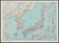
- Beinecke Rare Book and Manuscript Library > Japan and Korea / compiled and drawn in the Cartographic Section of the National Geographic Society ; James M. Darley, chief cartographer.
- Creator:
- National Geographic Society (U.S.). Cartographic Division
- Published / Created:
- 1945
- Call Number:
- 57 1945
- Container / Volume:
- BRBL_00303
- Image Count:
- 1
- Resource Type:
- Maps, Atlases & Globes
- Found in:
- Beinecke Rare Book and Manuscript Library > Japan and Korea / compiled and drawn in the Cartographic Section of the National Geographic Society ; James M. Darley, chief cartographer.
- Creator:
- United States. Army Map Service
- Published / Created:
- 1945
- Call Number:
- 57 1945A
- Container / Volume:
- BRBL_00303
- Image Count:
- 2
- Resource Type:
- Maps, Atlases & Globes
- Found in:
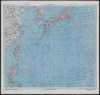
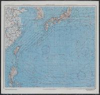
- Beinecke Rare Book and Manuscript Library > Japan and South China Seas / prepared at the direction of the commanding general, Army Air Forces, for the Aeronautical Chart Service by the Lake Survey Branch, Army Map Service, Detroit, Michigan, March 1945.
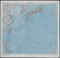
- Creator:
- United States. Army Map Service
- Published / Created:
- 1945
- Call Number:
- 50 1945D
- Container / Volume:
- BRBL_00273
- Image Count:
- 2
- Resource Type:
- Maps, Atlases & Globes
- Found in:
- Beinecke Rare Book and Manuscript Library > Japan and South China Seas / prepared at the direction of the commanding general, Army Air Forces, for the Aeronautical Chart Service by the Lake Survey Branch, Army Map Service, Detroit, Michigan, March 1945.