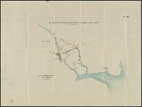
Jasin & Umba Valley boundary, no. 26, Map annexed to arrangement between Great Britain and Germany fixing the boundary at Jassin and in the bend of the Umba River, East Africa, and No. 26, Jasin and Umba Valley boundary
Description:
"Auf die Böhler'sche Karte K.V. no. 109 zu legen." and Panel title.
Publisher:
Ordnance Survey?,
Subject (Geographic):
Kenya--Boundaries--Tanzania--Maps and Tanzania--Boundaries--Kenya--Maps
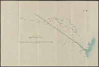
Jasin & Umba Valley boundary, no. 27, No. 27, Jasin and Umba Valley boundary, and Sketch map annexed to arrangement between Great Britain and Germany fixing the boundary at Jassin and in the bend of the Umba River, East Africa
Description:
"Aufzulegen auf Karte Int. Div. War Office no. 977." and Panel title.
Publisher:
Ordnance Survey?,
Subject (Geographic):
Kenya--Boundaries--Tanzania--Maps and Tanzania--Boundaries--Kenya--Maps
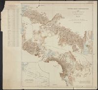
Map of the country north and south of the Anglo German boundary reduced from the surveys of the British and German sections of the Commissions during the years 1904-1906
Description:
"Note. For information concerning the construction of this map, see the paper by Captain G.E. Smith, R.E., and the note by Captain T.T. Behrens, R.E., in the 'Geographical Journal' for March and July 1907.", "Section II.", and In upper right margin: Victoria Ny
Publisher:
Royal Geographical Society,
Subject (Geographic):
Kenya--Boundaries--Tanzania--Maps and Tanzania--Boundaries--Kenya--Maps