Search
You Searched For
Search Results
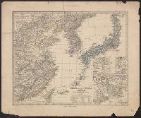
- Creator:
- Rand McNally and Company
- Published / Created:
- c1901.
- Call Number:
- 56 1901A
- Container / Volume:
- BRBL_00296
- Image Count:
- 2
- Resource Type:
- Maps, Atlases & Globes
- Alternative Title:
- Four-track series., Map of Asia, and New map of Asia and the Chinese empire as they are to-day :
- Description:
- "Printed for the New York Central's 'Four-Track Series. No. 28'"
- Publisher:
- Rand, McNally & Co. ,
- Subject (Geographic):
- China--Maps, Japan--Maps, and Korea--Maps
- Subject (Name):
- New York Central and Hudson River Railroad Company
- Subject (Topic):
- Transportation--China--Maps, Transportation--Japan--Maps, and Transportation--Korea--Maps
- Found in:
- Beinecke Rare Book and Manuscript Library > A new map of the Chinese Empire with Japan and Korea. Map of Asia. / by Rand, McNally & Co.
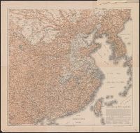
- Creator:
- United States. Hydrographic Office
- Published / Created:
- 1904
- Call Number:
- 57 1904
- Container / Volume:
- BRBL_00302
- Image Count:
- 1
- Resource Type:
- Maps, Atlases & Globes
- Alternative Title:
- Charts, etc.
- Description:
- "No. 2156."
- Publisher:
- Hydrographic Office,
- Subject (Geographic):
- China--Maps, Japan--Maps, and Korea--Maps
- Found in:
- Beinecke Rare Book and Manuscript Library > Asia, Japan and Korea : with the surrounding seas and the adjacent coastal region of China / published at Washington, D.C. Feb. 1904, at the Hydrographic Office. H.M. Hodges, Lieutenant Commander, U.S.N. Hydrographer.
- Creator:
- United States. Hydrographic Office
- Published / Created:
- 1904
- Call Number:
- 556cea 1904
- Container / Volume:
- BRBL_00293
- Image Count:
- 1
- Resource Type:
- Maps, Atlases & Globes
- Alternative Title:
- Charts, etc.
- Description:
- "No. 2156."
- Publisher:
- Hydrographic Office,
- Subject (Geographic):
- China--Maps, Japan--Maps, and Korea--Maps
- Found in:
- Beinecke Rare Book and Manuscript Library > Asia, Japan and Korea : with the surrounding seas and the adjacent coastal region of China / published at Washington, D.C. Feb. 1904, at the Hydrographic Office. H.M. Hodges, Lieutenant Commander, U.S.N. Hydrographer.
- Creator:
- Petermann, A. (August), 1822-1878
- Published / Created:
- 1877
- Call Number:
- 56 1877
- Container / Volume:
- BRBL_00296
- Image Count:
- 1
- Resource Type:
- Maps, Atlases & Globes
- Alternative Title:
- China (östlicheTheil), Korea und Japan im Massstab 1:7.500.000
- Description:
- From Stieler's Hand-Atlas.
- Publisher:
- Justus Perthes,
- Subject (Geographic):
- China--Maps, Japan--Maps, and Korea--Maps
- Subject (Name):
- Debes, E. (Ernst), 1840-1923
- Found in:
- Beinecke Rare Book and Manuscript Library > China (östl. Theil), Korea und Japan im Massstab 1:7.500.000 / von A. Petermann ; bearbeitet von Ernst Debes ; gestochen v. H. Eberhardt ; Terrain v. C. Jungmann.
- Creator:
- Hoebel, Paul
- Published / Created:
- 1910
- Call Number:
- 56 1901
- Container / Volume:
- BRBL_00296
- Image Count:
- 4
- Resource Type:
- Maps, Atlases & Globes
- Alternative Title:
- Hoebels Karte von China
- Description:
- Includes text.
- Publisher:
- Meisenbach, Riffarth & Co.,
- Subject (Geographic):
- China--Maps and Korea--Maps
- Subject (Name):
- Pilger, F
- Found in:
- Beinecke Rare Book and Manuscript Library > Hoebels Karte v. China [cartographic material] / gezeichnet und übersetzt von Paul Hoebel, Terrainzeichnung von F. Pilger.
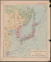
- Creator:
- Antonio Vallardi (Firm)
- Published / Created:
- [1904]
- Call Number:
- 556hc 1904
- Container / Volume:
- BRBL_00294
- Image Count:
- 1
- Resource Type:
- Maps, Atlases & Globes
- Description:
- In upper margin: Supplemento Straordinario al N. 15933 (13 febbraio 1904) dato agli abbonati della "Perseveranza".
- Publisher:
- Antonio Vallardi, editore,
- Subject (Geographic):
- Japan--Maps and Korea--Maps
- Found in:
- Beinecke Rare Book and Manuscript Library > Il conflitto Russo-Giappanese : [map of the region].
- Creator:
- Pinkerton, John, 1758-1826
- Published / Created:
- 1809
- Call Number:
- 57 1809
- Container / Volume:
- BRBL_00301
- Image Count:
- 1
- Resource Type:
- Maps, Atlases & Globes
- Description:
- "Pinkerton's modern atlas " appears above border at center of map.
- Publisher:
- Cadell & Davies,
- Subject (Geographic):
- Japan--Maps and Korea--Maps
- Subject (Name):
- Cadell & Davies, Hebert, L, Neele, Samuel John, 1758-1824, and Pinkerton, John, 1758-1826. Modern atlas
- Found in:
- Beinecke Rare Book and Manuscript Library > Japan / drawn under the direction of Mr. Pinkerton by L. Hebert ; Neele sculpt.
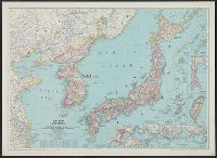
- Creator:
- National Geographic Society (U.S.). Cartographic Division
- Published / Created:
- 1945
- Call Number:
- 57 1945
- Container / Volume:
- BRBL_00303
- Image Count:
- 1
- Resource Type:
- Maps, Atlases & Globes
- Description:
- "Albers conical equal-area projection."
- Publisher:
- National Geographic Society,
- Subject (Geographic):
- Japan--Maps and Korea--Maps
- Found in:
- Beinecke Rare Book and Manuscript Library > Japan and Korea / compiled and drawn in the Cartographic Section of the National Geographic Society ; James M. Darley, chief cartographer.
- Creator:
- United States. Army Map Service
- Published / Created:
- 1945
- Call Number:
- 574gm 1945A
- Container / Volume:
- BRBL_00311
- Image Count:
- 1
- Resource Type:
- Maps, Atlases & Globes
- Alternative Title:
- Korea, Korea, scale 1:1,000,000, and Series L302
- Description:
- "141098."
- Publisher:
- Army Map Service,
- Subject (Geographic):
- Korea--Maps
- Found in:
- Beinecke Rare Book and Manuscript Library > Japan road map 1:1,000,000. sheet 4, Korea / prepared under the direction of the Chief of Engineers, U.S. Army, by the Army Map Service (GD) ... 1945.