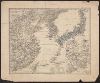
Four-track series., Map of Asia, and New map of Asia and the Chinese empire as they are to-day :
Description:
"Printed for the New York Central's 'Four-Track Series. No. 28'", From panel-title: Issued by the Passenger Department of the New York Central and Hudson River R.R. Copyright 1901 by Geo. H. Daniels General Passenger Agent.", and Recto: advertisements and schedules for trains with text and ill.
Publisher:
Rand, McNally & Co. ,
Subject (Geographic):
China--Maps, Japan--Maps, and Korea--Maps
Subject (Name):
New York Central and Hudson River Railroad Company
Subject (Topic):
Transportation--China--Maps, Transportation--Japan--Maps, and Transportation--Korea--Maps
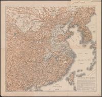
China (östlicheTheil), Korea und Japan im Massstab 1:7.500.000
Description:
From Stieler's Hand-Atlas., In upper left: Stieler's Hand Atlas, N⁰ 65., Insets: Schanghai und Umgebung -- Jedo und Umgebung -- Der Canton-Strom und seine Umgebung., Prime meridians: Greenwich, Ferro, Paris., and Relief shown by hachures.
In upper margin: Supplemento Straordinario al N. 15933 (13 febbraio 1904) dato agli abbonati della "Perseveranza"., Relief shown by shading., and Shows railroads.
"Pinkerton's modern atlas " appears above border at center of map., Covers also Korea., Number "33" on upper right hand corner., and Relief shown by hachures.
Publisher:
Cadell & Davies,
Subject (Geographic):
Japan--Maps and Korea--Maps
Subject (Name):
Cadell & Davies, Hebert, L, Neele, Samuel John, 1758-1824, and Pinkerton, John, 1758-1826. Modern atlas
National Geographic Society (U.S.). Cartographic Division
Published / Created:
1945
Call Number:
57 1945
Container / Volume:
BRBL_00303
Image Count:
1
Resource Type:
Maps, Atlases & Globes
Description:
"Albers conical equal-area projection.", Copy 2 mounted on linen., Includes glossary of geographical terms., and Insets: 1-2. Kuril Islands.--3. Pescadores.--4. Karafuto.--5-7. Ryukyu Islands.--8. Formosa.--9. Tokyo.--10. Location of Japan in the Western Pacific
National Geographic Society (U.S.). Cartographic Division
Published / Created:
1945
Call Number:
57 1945
Container / Volume:
BRBL_00303
Image Count:
1
Resource Type:
Maps, Atlases & Globes
Description:
"Albers conical equal-area projection.", Includes glossary of g, Insets: 1-2. Kuril Islands.--3. Pescadores.--4. Karafuto.--5-7. Ryukyu Islands.--8. Formosa.--9. Tokyo.--10. Location of Japan in the Western Pacific., and Relief shown by shading and spot heights.
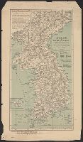
"141098.", "8-45.", "A.M.S. L302.", "Compiled from Korea Relief Map, 1:1,000,000, AAF, 1944 ...", "Type A-AMS 1.", Includes notes, glossary, "Conversion graph," and adjoining sheets index., Relief shown by shading and spot heights., and Standard map series designati
Central Japan, Northern Japan, Series (Standard map series designation system) ; L302., and Series ; L302
Description:
Imperfect: sheet 3, sheet 4 wa, Includes "glossary" and sheet index map., Includes index., Relief indicated by shading; spot heights in meters., and Sheet 1. Northern Japan -- Sheet 2. Central Japan -- Sheet 3. Southern Japan -- Sheet 4. Korea.
Islands of Japan, Japanese nobleman & fishermen., Japanese women of the higher & lower class., and Port of Simonoseke, Japan.
Description:
Imperfect: trimmed at right, with some loss of text., Inset map: Port of Nagasaki in the island of Kiou-siou. Scale approximately 1:180,000., Shows soundings., and Vignettes in top margin [by John Dunlop]: Port of Simonoseke, Japan -- Japanese nobleman & fishermen -- Japanese women of the higher & lower class.
Publisher:
A. Fullarton & Co.,
Subject (Geographic):
Amur River (China and Russia)--Maps., Japan--Maps, Korea--Maps, Manchuria (China)--Maps., and Nagasaki-shi Region (Japan)--Maps.
Subject (Name):
A. Fullarton & Co., publisher, Bartholomew, John, 1805-1861, engraver, and Dunlop, John, artist.
Institut ėtnografii imeni N.N. Miklukho-Maklai︠a︡ Институт этнографии имени Н.Н. Миклухо-Маклая
Published / Created:
1959
Call Number:
56ed 1959
Container / Volume:
BRBL_00298
Image Count:
2
Resource Type:
Maps, Atlases & Globes
Alternative Title:
Naselenie Kitai︠a︡, MNR i Korei. and Карта народов Китая, МНР и Кореи / составлена в 1958 г. Институтом этнографии имени Н.Н. Миклухо-Маклая Академии наук СССР и Научно-редакционной картосоставительской частью ГУГК ; под общим руководством П.Е. Терлецкого ; а
Description:
Accompanied by explanatory pamphlet with title: Naselenie Kitai︠a︡, MNR i Korei by S.I. Bruk., Accompanied by explanatory pamphlet with title: Население Китая, МНР и Кореи by S.I. Bruk., Legend also in Chinese., and Title from envelope in which issued.
Publisher:
Glavnoe upravlenie geodezii i kartografii MVD SSSR :, Institut ėtnografii imeni N.N. Miklukho-Maklai︠a︡ Akademii nauk SSSR,, Главное управление геодезии и картографии МВД СССР :, and Институт этнографии имени Н.Н. Миклухо-Маклая Академии наук СССР,
Subject (Geographic):
China--Maps, Korea--Maps, and Mongolia--Maps
Subject (Name):
Bruk, Solomon Ilʹich, Soviet Union. Glavnoe upravlenie geodezii i kartografii, Soviet Union. Главное управление геодезии и картографии, Terlet︠s︡kiĭ, P. E, Брук, Соломон Ильич, and Терлецкий, П. Е
Subject (Topic):
Ethnology--China--Maps, Ethnology--Korea--Maps, and Ethnology--Mongolia--Maps
United States. Office of Strategic Services. Research and Analysis Branch
Published / Created:
1945
Call Number:
574gm 1945BA
Container / Volume:
BRBL_00311
Image Count:
1
Resource Type:
Maps, Atlases & Globes
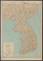
Alternative Title:
Korea roads and railroads
Description:
"No. 6171 ... 28 February 1945.", Includes glossary with Korean, Japanese, English and Chinese terms., Inset: Ullŭng-do., and Oriented with north to left.
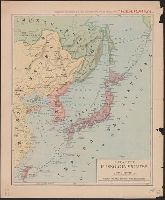
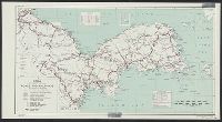
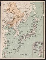
"Drawn by Chas. L. Hoopes.", Inset is continuation of main map., Inset: southern Korea, Korea Strait, northern Japan. Scale [ca. 1:3,960,000]., Relief shown by shading., and Shows boundaries between Manchuria and northern Korea, Mongolia and Siberia at the end of the Russo-Japanese War. Indicates railroads and submarine cables.
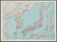
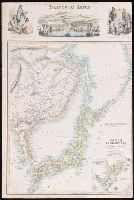
"The London Geographical Institute, M.C.H.", Includes inset maps of Taiwan (Formosa) and Karafuto (Sakhalin), same scale., and Shows Japan, Korea, and the eastern coast of China, railways, air routes, and shipping routes.
"The London Geographical Institute, M.C.H.", Includes inset maps of Taiwan (Formosa) and Karafuto (Sakhalin), same scale., and Shows Japan, Korea, and the eastern coast of China, railways, air routes, and shipping routes.