Search
You Searched For
Search Results
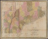
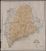
- Creator:
- Mitchell, S. Augustus (Samuel Augustus), 1792-1868
- Published / Created:
- 1847
- Call Number:
- 76 1847A
- Container / Volume:
- BRBL_00445
- Image Count:
- 1
- Resource Type:
- Maps, Atlases & Globes
- Found in:
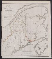
- Beinecke Rare Book and Manuscript Library > Map of Maine, New Hampshire, and Vermont : compiled from the latest authorities / published by S. Augustus Mitchell ; J.H. Young Sc. ; sold by Thomas, Cowperthwait & Co.
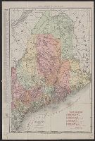
- Creator:
- Rand McNally and Company
- Published / Created:
- c1911.
- Call Number:
- 761gme 1911
- Container / Volume:
- BRBL_00449
- Image Count:
- 1
- Resource Type:
- Maps, Atlases & Globes
- Found in:
- Beinecke Rare Book and Manuscript Library > Maine / Rand McNally & Co.
- Published / Created:
- 1915
- Call Number:
- 761 R16 1915
- Container / Volume:
- BRBL_00449
- Image Count:
- 1
- Resource Type:
- Maps, Atlases & Globes
- Found in:
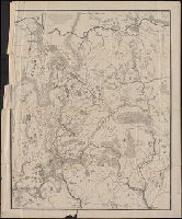
- Beinecke Rare Book and Manuscript Library > Sportsmen and tourist map : of the entire Rangeley Lakes, Dead River Region, King and Bartletts Lakes, Seven Ponds, Spider and Megantic Lakes, Chain of Ponds, Magalloway and Cupsuptic Rivers, Kennebago and Parmachenee Lakes, and giving all lakes and ponds
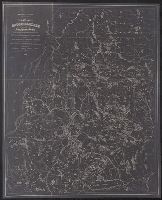
- Published / Created:
- 1860
- Call Number:
- 761gme 1860
- Container / Volume:
- BRBL_00449
- Image Count:
- 1
- Resource Type:
- Maps, Atlases & Globes
- Found in:
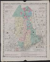
- Beinecke Rare Book and Manuscript Library > Map of the Eastern part of Maine : showing the settling land in Piscataquis and Aroostook counties with the proposed lines of rail roads to promote the sale and settlement of public lands & land owned by individuals, also rail road communication with the
- Creator:
- Maine. Board of Railroad Commissioners
- Published / Created:
- c1891.
- Call Number:
- 761gme 1891
- Container / Volume:
- BRBL_00449
- Image Count:
- 1
- Resource Type:
- Maps, Atlases & Globes
- Found in:
- Beinecke Rare Book and Manuscript Library > Map of the railroads of the state of Maine accompanying the report of the railroad commissioners, 1892 / prepared for the Board of Railroad Commissioners under the direction of William A. Allen ; H.C. Robinson, E.A. Boothby, draughtsmen.
- Published / Created:
- 19--.
- Call Number:
- 761 M79 1883
- Container / Volume:
- BRBL_00448
- Image Count:
- 1
- Resource Type:
- Maps, Atlases & Globes
- Found in:
- Beinecke Rare Book and Manuscript Library > [Map of Moosehead Lake and northern Maine, embracing the headwaters of the Penobscot, Kennebec and St. John rivers : specially adapted to the uses of sportsmen and lumbermen / compiled and published by Lucius L. Hubbard].
- Published / Created:
- 19--.
- Call Number:
- 761 R16 1880
- Container / Volume:
- BRBL_00449
- Image Count:
- 1
- Resource Type:
- Maps, Atlases & Globes
- Found in:
- Beinecke Rare Book and Manuscript Library > [Map of the Rangeley Lake District, Maine] / copied from the surveys of Ballard and Perham & co. from a scale of 2 miles to an inch by Osgood Carleton.
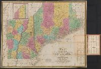
- Creator:
- Mitchell, S. Augustus (Samuel Augustus), 1792-1868
- Published / Created:
- 1831
- Call Number:
- 76 1831A
- Container / Volume:
- BRBL_00444
- Image Count:
- 1
- Resource Type:
- Maps, Atlases & Globes
- Found in:
- Beinecke Rare Book and Manuscript Library > Map of Maine, New Hampshire, and Vermont / compiled from the latest authorities.
- Published / Created:
- 1830
- Call Number:
- 761 1830
- Container / Volume:
- BRBL_00729
- Image Count:
- 1
- Resource Type:
- Maps, Atlases & Globes
- Found in:
- Beinecke Rare Book and Manuscript Library > Map of the Northern part of the state of Maine and of the adjacent British provinces, showing the portion of that state to wich Great britain lays claim, reduced from the latest surveys by S.L. Dashiell ...
- Published / Created:
- [after 1842]
- Call Number:
- BrSides Elephant Folio 2018 19
- Image Count:
- 1
- Resource Type:
- Maps, Atlases & Globes
- Found in:
- Beinecke Rare Book and Manuscript Library > [Manuscript map of the northern third of Maine].