Search
You Searched For
Search Results
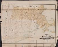
- Published / Created:
- 1884
- Call Number:
- 764gme 1884
- Container / Volume:
- BRBL_00462
- Image Count:
- 1
- Resource Type:
- Maps, Atlases & Globes
- Found in:
- Beinecke Rare Book and Manuscript Library > Map of the railroads of the state of Massachusetts : accompanying the report of the Railroad Commissioners.
- Creator:
- Massachusetts. Board of Railroad Commissioners
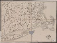
- Published / Created:
- 1874
- Call Number:
- 764gme 1874
- Container / Volume:
- BRBL_00462
- Image Count:
- 1
- Resource Type:
- Maps, Atlases & Globes
- Found in:
- Beinecke Rare Book and Manuscript Library > Map of the railroads of the state of Massachusetts : accompanying the report of the railroad commissioners. 1874.
- Published / Created:
- c1891
- Call Number:
- 764 P74 1891
- Container / Volume:
- BRBL_00459
- Image Count:
- 1
- Resource Type:
- Maps, Atlases & Globes
- Found in:
- Beinecke Rare Book and Manuscript Library > Massachusetts atlas plate no. 6 [Southern Norfolk and Plymouth counties].
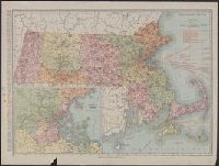
- Creator:
- Rand McNally and Company
- Published / Created:
- [1911]
- Call Number:
- 764 1911
- Container / Volume:
- BRBL_00453
- Image Count:
- 1
- Resource Type:
- Maps, Atlases & Globes
- Found in:
- Beinecke Rare Book and Manuscript Library > Massachusetts.
- Creator:
- Massachusetts. Metropolitan Park Commission
- Published / Created:
- 1908
- Call Number:
- 764 B65 1908
- Container / Volume:
- BRBL_00456
- Image Count:
- 1
- Resource Type:
- Maps, Atlases & Globes
- Found in:
- Beinecke Rare Book and Manuscript Library > Plan for proposed park and parkways : from Charles River Reservation to West Roxbury Parkway connecting the northern and southern group of metropolitan parks.
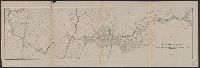
- Published / Created:
- 1877
- Call Number:
- 764 H76 1877
- Container / Volume:
- BRBL_00457
- Image Count:
- 1
- Resource Type:
- Maps, Atlases & Globes
- Found in:
- Beinecke Rare Book and Manuscript Library > Profile of Hoosac Mountain showing tunnel, 1877.
- Creator:
- Horace Thayer & Co
- Published / Created:
- 1853
- Call Number:
- 76 1853
- Container / Volume:
- BRBL_00445
- Image Count:
- 1
- Resource Type:
- Maps, Atlases & Globes
- Found in:
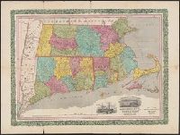
- Beinecke Rare Book and Manuscript Library > Rail-road & township map of Massachusetts, Connecticut and Rhode Island.
- Creator:
- Rand McNally and Company
- Published / Created:
- [1921]
- Call Number:
- 764 1921
- Container / Volume:
- BRBL_00453
- Image Count:
- 2
- Resource Type:
- Maps, Atlases & Globes
- Found in:
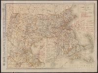
- Beinecke Rare Book and Manuscript Library > Rand McNally standard map of Massachusetts.
- Creator:
- Rand McNally and Company
- Published / Created:
- c1891.
- Call Number:
- 764 B65 1891
- Container / Volume:
- BRBL_00456
- Image Count:
- 1
- Resource Type:
- Maps, Atlases & Globes
- Found in:
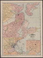
- Beinecke Rare Book and Manuscript Library > Rand, McNally & Co.'s indexed atlas of the world map of Boston.
- Published / Created:
- 1837
- Call Number:
- 764gme 1837
- Container / Volume:
- BRBL_00462
- Image Count:
- 2
- Resource Type:
- Maps, Atlases & Globes
- Found in:
- Beinecke Rare Book and Manuscript Library > Route of the Western Rail Road ... Enlarged from the Map of the State.