Search
You Searched For
Search Results
- Published / Created:
- 1802
- Call Number:
- 85 1802
- Container / Volume:
- BRBL_00637
- Image Count:
- 1
- Resource Type:
- Maps, Atlases & Globes
- Found in:
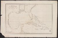
- Beinecke Rare Book and Manuscript Library > Carta esferica del Golfo de Mexico é Islas Antillas, para intelligenca de La America, construida segun las Cartas ultimante publics por la Direction Hidrogratia.
- Published / Created:
- 1825
- Call Number:
- 85cea 1825A
- Container / Volume:
- BRBL_00639
- Image Count:
- 1
- Resource Type:
- Maps, Atlases & Globes
- Found in:
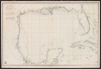
- Beinecke Rare Book and Manuscript Library > Carta esferica que comprende todas las Costas del seno Mexicano Golfo de Honduras, Islas de Cuba, Santo Domingo, Jamayca y Lucayas ... Mexico año 1825.
- Published / Created:
- 1846
- Call Number:
- 85cea 1846
- Container / Volume:
- BRBL_00639
- Image Count:
- 1
- Resource Type:
- Maps, Atlases & Globes
- Found in:
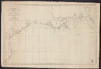
- Beinecke Rare Book and Manuscript Library > Carta de las Costas de la Escambia, Alabama y boca del Rio Misisipi, La Luisiana, Tejas ... en el Golfo de Mejico. construida en la Direccion de Hidrografia ...
- Published / Created:
- 1803
- Call Number:
- 85cea 1803
- Container / Volume:
- BRBL_00639
- Image Count:
- 1
- Resource Type:
- Maps, Atlases & Globes
- Found in:
- Beinecke Rare Book and Manuscript Library > Carta Esferica que comprende las costas del Seno Mexicano construida de ordes del Rey en el deposito hidrografico de marina ...
- Creator:
- Butterfield, Carlos
- Published / Created:
- [1859]
- Call Number:
- 75 1859
- Container / Volume:
- BRBL_00401
- Image Count:
- 1
- Resource Type:
- Maps, Atlases & Globes
- Found in:
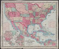
- Beinecke Rare Book and Manuscript Library > Map of the United States and Mexico / published by Johnson & Browning under the direction of Col. Carlos Butterfield.
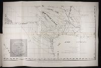
- Call Number:
- Zc20 931pi
- Collection Title:
- Pichardo’s treatise on the limits of Louisiana and Texas : an argumentative historical treatise
- Image Count:
- 1
- Found in:
- Beinecke Rare Book and Manuscript Library > Section of Pichardo's map of New Mexico and adjacent regions, drawn in 1811 to assist in the determination of the boundaries between the Spanish dominions and the United States.