Search
You Searched For
Search Results
- Published / Created:
- 1836
- Call Number:
- 811 1836
- Container / Volume:
- BRBL_00552
- Image Count:
- 1
- Resource Type:
- Maps, Atlases & Globes
- Found in:
- Beinecke Rare Book and Manuscript Library > An improved edition of a map of the survryed part of the Territory of Michigan. by John Farmer
- Published / Created:
- 1858
- Call Number:
- 811cea Sa245 1858
- Container / Volume:
- BRBL_00554
- Image Count:
- 1
- Resource Type:
- Maps, Atlases & Globes
- Found in:
- Beinecke Rare Book and Manuscript Library > Channel cut of Middle Channel, Lake George : St. Mary's River improvement showing character of bottom & extent of dredging up to September 30th 1858 / drawn by James T. Baker, surveyed under the orders of Capt. A.W. Whipple, T.E., by J.H. Forster U.S. Sub
- Published / Created:
- 1858
- Call Number:
- 811cea Sa245 1858A
- Container / Volume:
- BRBL_00554
- Image Count:
- 1
- Resource Type:
- Maps, Atlases & Globes
- Found in:
- Beinecke Rare Book and Manuscript Library > Chart of East Neebish rapids, River St. Mary : showing the improved west channel, dredged and surveyed in 1858 under the direction of Capt. A.W. Whipple, T.E. / J.H. Foster U.S. Sub. Agt., James T. Foster, draughtsman.
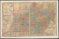
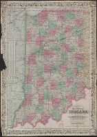
- Creator:
- Colton, J. H. (Joseph Hutchins), 1800-1893
- Published / Created:
- 1868
- Call Number:
- 805 1868
- Container / Volume:
- BRBL_00546
- Image Count:
- 1
- Resource Type:
- Maps, Atlases & Globes
- Found in:
- Beinecke Rare Book and Manuscript Library > Colton's map of the state of Indiana : compiled from the United States surveys and other authentic sources. Exhibiting sections, fractional sections, railroads, canals, etc.
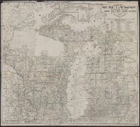
- Creator:
- Farmer, John, 1798-1859
- Published / Created:
- 1857
- Call Number:
- 754 1857
- Container / Volume:
- BRBL_00416
- Image Count:
- 1
- Resource Type:
- Maps, Atlases & Globes
- Found in:
- Beinecke Rare Book and Manuscript Library > Farmer's township map of Michigan and Wisconsin : embracing part of Iowa Illinois and Minnesota, with a chart of the lakes / prepared engraved and published by the author at Detroit.
- Creator:
- Winchell, Alexander, 1824-1891
- Published / Created:
- 1866
- Call Number:
- 811ca 1866
- Container / Volume:
- BRBL_00554
- Image Count:
- 1
- Resource Type:
- Maps, Atlases & Globes
- Found in:
- Beinecke Rare Book and Manuscript Library > Geological map of Michigan / by Alexander Winchell.
- Published / Created:
- 1915
- Call Number:
- 812ag 1915
- Container / Volume:
- BRBL_00556
- Image Count:
- 2
- Resource Type:
- Maps, Atlases & Globes
- Found in:
- Beinecke Rare Book and Manuscript Library > Hunting and fishing resorts of northern Wisconsin and Michigan : reached by the Chicago and North Western Railway.
- Creator:
- Johnson, A. J. (Alvin Jewett), 1827-1884
- Published / Created:
- [1866]
- Call Number:
- 812 1866
- Container / Volume:
- BRBL_00555
- Image Count:
- 2
- Resource Type:
- Maps, Atlases & Globes
- Found in:
- Beinecke Rare Book and Manuscript Library > Johnson's Wisconsin and Michigan.
- Creator:
- Burr, David H., 1803-1875
- Published / Created:
- [1839?]
- Call Number:
- 811 1839A
- Container / Volume:
- BRBL_00552
- Image Count:
- 4
- Resource Type:
- Maps, Atlases & Globes
- Found in:
- Beinecke Rare Book and Manuscript Library > Map of Michigan & part of Wisconsin Territory : exhibiting the post offices, post roads, canals, rail roads, &c. / by David H. Burr.
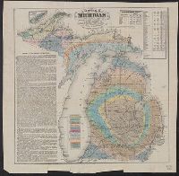
- Creator:
- Winchell, Alexander, 1824-1891
- Published / Created:
- 1873]
- Call Number:
- 811ca 1873
- Container / Volume:
- BRBL_00554
- Image Count:
- 1
- Resource Type:
- Maps, Atlases & Globes
- Found in:
- Beinecke Rare Book and Manuscript Library > Map of the state of Michigan colored to show the geological formations / by Alexander Winchell.
- Creator:
- Rand McNally and Company
- Published / Created:
- 1911
- Call Number:
- 811 1911
- Container / Volume:
- BRBL_00552
- Image Count:
- 2
- Resource Type:
- Maps, Atlases & Globes
- Found in:
- Beinecke Rare Book and Manuscript Library > Michigan, Southern Peninsula ; Michigan, Northern Peninsula.
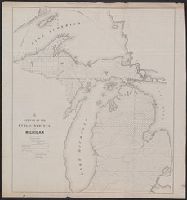
- Published / Created:
- [1831?]
- Call Number:
- 811 1831
- Container / Volume:
- BRBL_00552
- Image Count:
- 1
- Resource Type:
- Maps, Atlases & Globes
- Found in:
- Beinecke Rare Book and Manuscript Library > Michigan.
- Published / Created:
- 1853
- Call Number:
- 811 1853
- Container / Volume:
- BRBL_00552
- Image Count:
- 1
- Resource Type:
- Maps, Atlases & Globes
- Found in:
- Beinecke Rare Book and Manuscript Library > Neueste Karte von Michigan : nach den bessten Quellen bearbeitet.
- Creator:
- O.W. Gray & Son
- Published / Created:
- 1876
- Call Number:
- 811 1876
- Container / Volume:
- BRBL_00552
- Image Count:
- 1
- Resource Type:
- Maps, Atlases & Globes
- Found in:
- Beinecke Rare Book and Manuscript Library > Railroad map of Michigan / prepared for the Commissioner of Railroads by O.W. Gray & Son.
- Published / Created:
- 1880
- Call Number:
- 811 1880
- Container / Volume:
- BRBL_00552
- Image Count:
- 1
- Resource Type:
- Maps, Atlases & Globes
- Found in:
- Beinecke Rare Book and Manuscript Library > Railroad map of Michigan / prepared for the Commissioner of railroads.
- Published / Created:
- 1900
- Call Number:
- 811 1900
- Container / Volume:
- BRBL_00552
- Image Count:
- 2
- Resource Type:
- Maps, Atlases & Globes
- Found in:
- Beinecke Rare Book and Manuscript Library > Rand, McNally & Co.'s Michigan, Southern.
- Creator:
- Rand McNally and Company
- Published / Created:
- 1879
- Call Number:
- 811 1879
- Container / Volume:
- BRBL_00552
- Image Count:
- 1
- Resource Type:
- Maps, Atlases & Globes
- Found in:
- Beinecke Rare Book and Manuscript Library > Rand, McNally & Co.'s township, county and railroad map of Michigan and the entire Upper Lake Region : showing the celebrated mining districts of the Upper Peninsula / compiled from the U.S. Land Office and Lake Surveys, County Surveys, etc.
- Published / Created:
- [1847]
- Call Number:
- 811fcm 1847
- Container / Volume:
- BRBL_00554
- Image Count:
- 1
- Resource Type:
- Maps, Atlases & Globes
- Found in:
- Beinecke Rare Book and Manuscript Library > Sketch of the Public Surveys in Michigan.
- Creator:
- Noble, Charles
- Published / Created:
- 1850
- Call Number:
- 811fcm 1850
- Container / Volume:
- BRBL_00554
- Image Count:
- 1
- Resource Type:
- Maps, Atlases & Globes
- Found in:
- Beinecke Rare Book and Manuscript Library > Sketch of the public surveys in Michigan / Surveyor General's Office, Detroit, November 12th, 1850, Charles Noble, Surveyor General.
- Creator:
- Haas, P
- Published / Created:
- 1841]
- Call Number:
- 811fcm 1840
- Container / Volume:
- BRBL_00554
- Image Count:
- 1
- Resource Type:
- Maps, Atlases & Globes
- Found in:
- Beinecke Rare Book and Manuscript Library > Sketch of the public surveys in the north part of Michigan / lith. of P. Haas.