Skip to search
Skip to main content
Skip to first result
Search
You Searched For
Subject (Geographic)
Middle Atlantic States -- Maps -- Early works to 1800
New Search
Search Results
Creator:
Published / Created:
1755
Call Number:
2003 Folio 85
Image Count:
1
Found in:
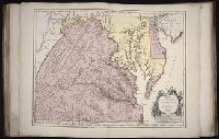
Beinecke Rare Book and Manuscript Library > Carte de la Virginie et du Maryland
Creator:
Published / Created:
[1755]
Call Number:
2003 Folio 85
Image Count:
1
Found in:
Beinecke Rare Book and Manuscript Library > A map of the most inhabited part of Virginia containing the whole province of Maryland: with part of Pensilvania, New Jersey and North Carolina
Creator:
Published / Created:
1635
Call Number:
1988 Folio 13
Collection Title:
Theatrum orbis terrarum. French
Image Count:
3
Found in:
Beinecke Rare Book and Manuscript Library > La Nouvelle Belgique & la Nouvelle Angleterre
Branch:v1.60.98 ,Deployed:2024-04-24T10:14:30-04:00