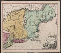
Cf. McCorkle, B.B. New England in early printed maps 1513-1800, no. 724.1., Map features New Jersey, New York and New England., Relief represented pictorially., and Sheet measures 51.5 x 60.4 cm.
Publisher:
[s.n.,
Subject (Geographic):
New England--Maps--Early works to 1800, New Jersey--Maps--Early works to 1800, and New York--Maps--Early works to 1800
Cf. McCorkle, B.B. New England in early printed maps 1513-1800, no. 724.1., Map features New Jersey, New York and New England., Relief represented pictorially., and Sheet measures 53.1 x 64.8 cm. Ms. no. on verso: 226. Cross Collection no. 182.
Publisher:
[s.n.,
Subject (Geographic):
New England--Maps--Early works to 1800, New Jersey--Maps--Early works to 1800, and New York--Maps--Early works to 1800
"Cum privilegio Sac. Caes. Maj.", Map features New Jersey, New York and New England., Relief represented pictorially., and Sheet measures 53.6 x 62.3 cm. Ms. no. on verso: 141. Title in ms. on verso. Franklin Collection no. 131 1759-2.
Publisher:
[s.n.,
Subject (Geographic):
New England--Maps--Early works to 1800, New Jersey--Maps--Early works to 1800, and New York--Maps--Early works to 1800