Search
You Searched For
Search Results
- Creator:
- Dripps, M. (Matthew)
- Published / Created:
- 1868
- Call Number:
- 771 N49 1868D
- Container / Volume:
- BRBL_00487
- Image Count:
- 21
- Resource Type:
- Maps, Atlases & Globes
- Found in:
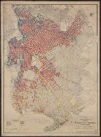
- Beinecke Rare Book and Manuscript Library > Plan of New York City from the Battery to Spuyten Duyvil Creek : showing every lot and building thereon; old farm lines, street numbers at the corners of blocks, railroads, steamboat landings, bulkhead and pier lines, etc., etc., etc. / based on the surve
- Creator:
- New York (N.Y.). Bureau of Highways
- Published / Created:
- 1913
- Call Number:
- 771 B796 1913
- Container / Volume:
- BRBL_00481
- Image Count:
- 1
- Resource Type:
- Maps, Atlases & Globes
- Found in:
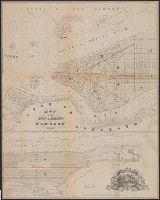
- Beinecke Rare Book and Manuscript Library > Map of the Borough of Brooklyn, City of New York [cartographic material]: showing street pavements other than cobblestone on January 1st, 1913./ Office of the President of the borough of Brooklyn, [and] Bureau of Highways.
- Published / Created:
- 1858
- Call Number:
- 771 N49 1858A
- Container / Volume:
- BRBL_00486
- Image Count:
- 1
- Resource Type:
- Maps, Atlases & Globes
- Found in:
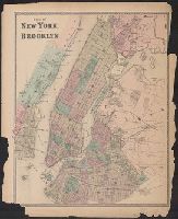
- Beinecke Rare Book and Manuscript Library > Map of the city & county of New-York.
- Creator:
- Magnus, Charles
- Published / Created:
- [1855]
- Call Number:
- 771 N49 1855
- Container / Volume:
- BRBL_00485
- Image Count:
- 1
- Resource Type:
- Maps, Atlases & Globes
- Found in:
- Beinecke Rare Book and Manuscript Library > New-York city and county map with vicinity entire, Brooklyn, Williamsburgh, Jersey City, &c. in the 79th year of the independence of the United States.
- Published / Created:
- [1867]
- Call Number:
- 771 N49 1867
- Container / Volume:
- BRBL_00487
- Image Count:
- 1
- Resource Type:
- Maps, Atlases & Globes
- Found in:
- Beinecke Rare Book and Manuscript Library > Map of New York and vicinity, [ect.]
- Published / Created:
- 1872?]
- Call Number:
- 771 N49 1868C
- Container / Volume:
- BRBL_00487
- Image Count:
- 1
- Resource Type:
- Maps, Atlases & Globes
- Found in:
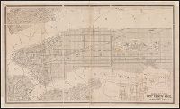
- Beinecke Rare Book and Manuscript Library > Plan of New York and Brooklyn.
- Published / Created:
- [1873?]
- Call Number:
- 771 N49 1873A
- Container / Volume:
- BRBL_00487
- Image Count:
- 1
- Resource Type:
- Maps, Atlases & Globes
- Found in:
- Beinecke Rare Book and Manuscript Library > Map of New York City. Drawn to accompany the 4th annual report of the Health Department by Wiliam Pistor, Eng / Am. Photo-Lithographic Co., N.Y.
- Creator:
- Miller, James
- Published / Created:
- [1857?]
- Call Number:
- 771 N49 1857A
- Container / Volume:
- BRBL_00486
- Image Count:
- 1
- Resource Type:
- Maps, Atlases & Globes
- Found in:
- Beinecke Rare Book and Manuscript Library > New York city map.
- Creator:
- City Directory
- Published / Created:
- [1871?]
- Call Number:
- 771 N49 1871C
- Container / Volume:
- BRBL_00487
- Image Count:
- 1
- Resource Type:
- Maps, Atlases & Globes
- Found in:
- Beinecke Rare Book and Manuscript Library > Map of the City of New York.