Search
You Searched For
Search Results
- Published / Created:
- [1909?]
- Call Number:
- 771 N49 1609
- Image Count:
- 1
- Resource Type:
- Maps, Atlases & Globes
- Found in:
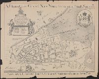
- Beinecke Rare Book and Manuscript Library > 1609 The Island of Manhattan (Mannahtin) at the time of its discovery ... L.L. Coates Engr'g Co., N.Y.
- Published / Created:
- [1909?]
- Call Number:
- 771 N49 1783
- Container / Volume:
- BRBL_00484
- Image Count:
- 1
- Resource Type:
- Maps, Atlases & Globes
- Found in:
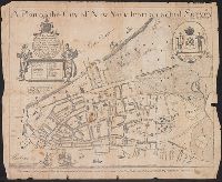
- Beinecke Rare Book and Manuscript Library > 1783 Manhattan Island at the close of the Revolution showing the American City with its Landmarks ... Fortifications ... L.L. Poates Engr'g Co., N.Y.
- Published / Created:
- [1710]
- Call Number:
- 771cea 1710
- Container / Volume:
- BRBL_00493
- Image Count:
- 1
- Resource Type:
- Maps, Atlases & Globes
- Found in:
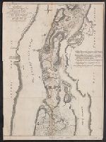
- Beinecke Rare Book and Manuscript Library > A Chart of the Sea Coasts of New Neder Land, Virginia, New England and Penn-Silvania with the city of Philadelphia from Boston to Cabo Karrit.
- Published / Created:
- 1797
- Call Number:
- 771 N49 1797
- Container / Volume:
- BRBL_00484
- Image Count:
- 1
- Resource Type:
- Maps, Atlases & Globes
- Found in:
- Beinecke Rare Book and Manuscript Library > A New & Accurate Plan of the City of New York in the State of New York in North America. Published in 1797.
- Published / Created:
- 1766
- Call Number:
- 771 N49 1766
- Container / Volume:
- BRBL_00484
- Image Count:
- 1
- Resource Type:
- Maps, Atlases & Globes
- Found in:
- Beinecke Rare Book and Manuscript Library > A plan of the City of New York and its environs ... John Montresor Engineer.
- Published / Created:
- 1766
- Call Number:
- 771 N49 1766
- Container / Volume:
- BRBL_00484
- Image Count:
- 1
- Resource Type:
- Maps, Atlases & Globes
- Found in:
- Beinecke Rare Book and Manuscript Library > A plan of the City of New York and its environs ... John Montresor Engineer.
- Published / Created:
- 1728
- Call Number:
- 771 N49 1728T
- Container / Volume:
- BRBL_00484
- Image Count:
- 1
- Resource Type:
- Maps, Atlases & Globes
- Found in:
- Beinecke Rare Book and Manuscript Library > A plan of the City of New York from an actual Survey made by James Lyne ... by Wm. Bradford.
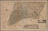
- Published / Created:
- 1728
- Call Number:
- 771 N49 1728S
- Container / Volume:
- BRBL_00484
- Image Count:
- 1
- Resource Type:
- Maps, Atlases & Globes
- Found in:
- Beinecke Rare Book and Manuscript Library > A plan of the City of New York from an actual Survey made by James Lyne ... by Wm. Bradford.
- Published / Created:
- 1728
- Call Number:
- 771 N49 1728L
- Container / Volume:
- BRBL_00484
- Image Count:
- 1
- Resource Type:
- Maps, Atlases & Globes
- Found in:
- Beinecke Rare Book and Manuscript Library > A plan of the City of New York from an actual Survey made by James Lyne ... by Wm. Bradford.
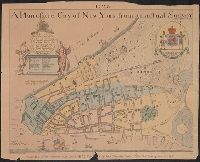
- Published / Created:
- [1728?]
- Call Number:
- 771 N49 1728A
- Container / Volume:
- BRBL_00484
- Image Count:
- 1
- Resource Type:
- Maps, Atlases & Globes
- Found in:
- Beinecke Rare Book and Manuscript Library > A plan of the City of New York from an actual Survey made by James Lyne ... by Wm. Bradford. 1728.
- Published / Created:
- 1728 [1874]
- Call Number:
- 771 N49 1728F
- Container / Volume:
- BRBL_00484
- Image Count:
- 1
- Resource Type:
- Maps, Atlases & Globes
- Found in:
- Beinecke Rare Book and Manuscript Library > A plan of the City of New York from an actual Survey made by James Lyne.
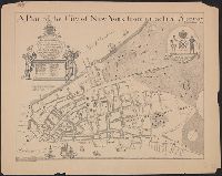
- Published / Created:
- [1728?]
- Call Number:
- 771 N49 1728
- Container / Volume:
- BRBL_00484
- Image Count:
- 1
- Resource Type:
- Maps, Atlases & Globes
- Found in:
- Beinecke Rare Book and Manuscript Library > A plan of the City of New York from an actual Survey. Made by James Lyne.
- Creator:
- Raspe, Gabriel Nicolaus, 1712-1785
- Published / Created:
- [1777]
- Call Number:
- 771 1777C
- Container / Volume:
- BRBL_00729
- Image Count:
- 1
- Resource Type:
- Maps, Atlases & Globes
- Found in:
- Beinecke Rare Book and Manuscript Library > Grundriss des nördlichen Theils der Neujorks Insel : nebst den am 16. Novbr. 1776 eroberten Fort Washington, nun das Fort Knijphausen genannt, und dem Fort Lee.
- Published / Created:
- [1793?]
- Call Number:
- 771 N49 1793
- Container / Volume:
- BRBL_00484
- Image Count:
- 1
- Resource Type:
- Maps, Atlases & Globes
- Found in:
- Beinecke Rare Book and Manuscript Library > Origin of steam navigation. A view of Collect pond and its vicinity in the city of New York in 1793 ... by John Hutchings ... Williamsburgh L.I., 1846.
- Published / Created:
- 1777
- Call Number:
- 771gmb N49 1777
- Container / Volume:
- BRBL_00494
- Image Count:
- 1
- Resource Type:
- Maps, Atlases & Globes
- Found in:
- Beinecke Rare Book and Manuscript Library > Plan de New-York [part of Manhattan] et des Environs levépar Montresor Ingenieur en 1775, A Paris.
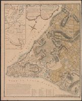
- Published / Created:
- [1767?]
- Call Number:
- 771 N49 1767A
- Container / Volume:
- BRBL_00484
- Image Count:
- 1
- Resource Type:
- Maps, Atlases & Globes
- Found in:
- Beinecke Rare Book and Manuscript Library > Plan of the City of New York ... B. Ratzer ... Thos. kitchin, Sculpt. ...
- Published / Created:
- [1797?]
- Call Number:
- 771 N49 1797A
- Container / Volume:
- BRBL_00484
- Image Count:
- 1
- Resource Type:
- Maps, Atlases & Globes
- Found in:
- Beinecke Rare Book and Manuscript Library > Plan of the city of New York.
- Published / Created:
- [1796?]
- Call Number:
- 771 N49 1796
- Container / Volume:
- BRBL_00484
- Image Count:
- 2
- Resource Type:
- Maps, Atlases & Globes
- Found in:
- Beinecke Rare Book and Manuscript Library > Plan of the city of New York. J.A. Del
- Published / Created:
- [1664?]
- Call Number:
- 771 N49 1664B
- Container / Volume:
- BRBL_00484
- Image Count:
- 1
- Resource Type:
- Maps, Atlases & Globes
- Found in:
- Beinecke Rare Book and Manuscript Library > The Nicolls Map [of Manhattan Island] 1664-1668. Presented to the New York Historical Society ... 1862.
- Call Number:
- 771ed 1614
- Container / Volume:
- BRBL_00493
- Image Count:
- 1
- Resource Type:
- Maps, Atlases & Globes
- Found in:
- Beinecke Rare Book and Manuscript Library > The original Carte Figurative of which the above is an accurate facsimile was found on the 26th June 1841 in the Loket Kas of the States General in the Royal Archives at the Haque, It may be the one referred to in Octroy of the States General dated 11th O
- Creator:
- Pownall, Thomas, 1722-1805
- Published / Created:
- 1776
- Call Number:
- Franklin 131 1776-5
- Image Count:
- 1
- Resource Type:
- Maps, Atlases & Globes
- Found in:
- Beinecke Rare Book and Manuscript Library > The provinces of New York and New Jersey [cartographic material] : with part of Pensilvania, and the Province of Quebec / drawn by Major Holland, Surveyor General, of the Northern District in America ; corrected and improved, from the original materials, by Governr. Pownall, Member of Parliament, 1776.
- Published / Created:
- 1776
- Call Number:
- 771 N49 1776
- Container / Volume:
- BRBL_00484
- Image Count:
- 1
- Resource Type:
- Maps, Atlases & Globes
- Found in:
- Beinecke Rare Book and Manuscript Library > This plan of the city of New York and its environs ... B. Ratzer ... Thos. Kitchin sculp.
- Published / Created:
- [ca. 1905]
- Call Number:
- 771 N49 1905R
- Image Count:
- 1
- Resource Type:
- Maps, Atlases & Globes
- Found in:
- Beinecke Rare Book and Manuscript Library > [New York City real estate].