Search
You Searched For
Search Results
- Creator:
- Dicquemare, M. l'abbé (Jacques-François), 1733-1789, cartographer
- Published / Created:
- June 17th, 1780.
- Call Number:
- 1982 Folio 10
- Image Count:
- 1
- Description:
- BEIN 1982 Folio 10: Armorial bookplate: Charles Abbot. No. 8 of 42 maps bound together.
- Publisher:
- Engraved & published by W. Faden
- Subject (Geographic):
- North Sea, English Channel, France, England, and Biscay, Bay of (France and Spain)
- Subject (Topic):
- Nautical charts, Coasts, and Navigation
- Found in:
- Beinecke Rare Book and Manuscript Library > A chart of the British Channel and the Bay of Biscay with a part of the North Sea, and the entrance of St. George's Channel
- Creator:
- Morden, Robert, -1703
- Published / Created:
- [ca. 1700]
- Call Number:
- 1973 Folio 10
- Image Count:
- 1
- Alternative Title:
- New map of the sea coasts of England, Scotland, and Ireland
- Description:
- BEIN 1973 Folio 10: Sheet measures 52 x 61.2 cm. Bookplate of José M. Rodriguez. No. 3 of 63 maps bound together.
- Publisher:
- Sold by Robert Morden at the Atlas in Cornhill and by Christopher Brown at the Globe in St. Paul's Church Yard
- Subject (Geographic):
- Great Britain and North Sea
- Subject (Topic):
- Coasts
- Found in:
- Beinecke Rare Book and Manuscript Library > A new mapp of the sea coasts of England, Scotland, and Ireland : with the adjacent coasts of France, Holand, Denmark & Norway, shewing the scituation and distance of the several ports, harbors, havens, creeks, sands &c.
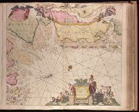
- Creator:
- Keulen, Johannes van, 1654-1715
- Published / Created:
- [ca. 1734]
- Call Number:
- 1973 Folio 18
- Image Count:
- 1
- Description:
- BEIN 1973 Folio 18: Imperfect: western sheet wanting. Backed with paper. Ms. no. "44" in upper right-hand corner. No. 42 of 87 maps bound together.
- Publisher:
- By Ioannes van Keulen, Boekverkooper en Graetboogmaaker aan de Nieubrug in de Gekroonde Loots-man
- Subject (Geographic):
- Groningen (Netherlands : Province), North Sea, and Lower Saxony (Germany)
- Subject (Topic):
- Maps and Nautical charts
- Found in:
- Beinecke Rare Book and Manuscript Library > Paskaarte vande kuste van Holland en Vriesland, Groeninger, Emder en Keydingerland, Holstyn, Ditmarsche en 't Eydersted met de Riviere Eylande Droogte en Diepten die geleege zijn tussen Olant en Egmont op Zee / [cartographic material]