Search
You Searched For
Search Results
- Published / Created:
- [1882].
- Call Number:
- 7325cea L93 1882
- Container / Volume:
- BRBL_00377
- Image Count:
- 1
- Resource Type:
- Maps, Atlases & Globes
- Found in:
- Beinecke Rare Book and Manuscript Library > Golfe de St. Laurent. Ile du Cap Breton : Port de Louisbourg. Copie du plan leve en 1857-1858 / par le Commandant ORLEBAR et autres Officiers de la Marine Royale Anglaise.
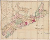
- Creator:
- A. & W. Mackinlay (Firm)
- Published / Created:
- 1865
- Call Number:
- 732 1865
- Container / Volume:
- BRBL_00376A
- Image Count:
- 1
- Resource Type:
- Maps, Atlases & Globes
- Found in:
- Beinecke Rare Book and Manuscript Library > Mackinlay's map of the province of Nova Scotia, including the island of Cape Breton : compiled from actual & recent surveys / drawn by W.A. Hendry ; engraved by G. Philip & Son, Liverpool.
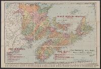
- Creator:
- Rand McNally and Company
- Published / Created:
- 1909
- Call Number:
- 733gme 1909A
- Container / Volume:
- BRBL_00379
- Image Count:
- 1
- Resource Type:
- Maps, Atlases & Globes
- Found in:
- Beinecke Rare Book and Manuscript Library > New Brunswick, Nova Scotia, and Prince Edward Island : The Maritime Provinces of Canada.
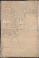
- Published / Created:
- 1865
- Call Number:
- 732cea H13 1853
- Container / Volume:
- BRBL_00378
- Image Count:
- 1
- Resource Type:
- Maps, Atlases & Globes
- Found in:
- Beinecke Rare Book and Manuscript Library > North America. Nova Scotia : South East Coast. Mars Head to Shut In Island / Surveyed by Captn. Bayfield R.N., Commr. J. Orlebar, Lieut. J. Hancock, , Mr. W. Forbes Master. and Mr. T Des Brisay Mastr. Assist. R.N. 1853.