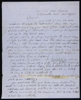
The letters to John Flett, special sub-Indian agent at Wapato Lake, request information about the Indians in his area and their attitude toward the hostile Indians, and give instructions on gathering the Indians in encampments. There is a letter from ...
Description:
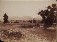
General Joel Palmer, first superintendent of Indian affairs for Oregon Territory.
Subject (Geographic):
Oregon
Subject (Name):
Blanchard, P. D., Flett, John, 1815-1892., Jennings, Berryman., and Palmer, Joel, 1810-1881.
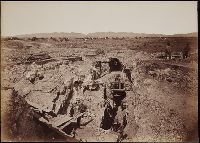
Photographs created from mammoth plate negatives primarily by photographers Carleton E. Watkins and William Henry Jackson of various locations in the American West, primarily in the states of California, Colorado, and Oregon, as well as Arizona, Monta...
Description:
A mammoth plate is a photographic negative plate, 18 by 21 inches (53.5 x 45.7 cm.) or larger, from which photographic prints are made through contact printing.
Subject (Geographic):
Wyoming, Montana, West (U.S.), Arizona, Arkansas River, Austin Bluffs (Colo.), Black Canyon of the Gunnison (Colo.), Blue Lakes (Calif.), Bridal Veil Falls (Utah), California, Cathedral Rocks (Calif.), Cathedral Spires (El Paso County, Colo.), Cathedral Spires (Jefferson County, Colo.), Clear Creek Canyon (Colo.), Clear Creek County (Colo.), Cochise Stronghold (Ariz.), Colorado, Columbia River, Costilla County (Colo.), Curecanti Needle (Colo.), Dalles (Or.), Dragoon Mountains (Ariz.), Drumlummon Mine (Mont.), Eagle Creek (Or.), Echo (Utah), El Capitan (Calif.), El Paso County (Colo.), Fountain Creek (Colo.), Fremont County (Colo.), Garden of the Gods (Colorado Springs, Colo.), Garfield County (Colo.), Gate Rock (El Paso County, Colo.), Giant Geyser (Wyo.), Glenwood Springs (Colo.), Grotto Geyser (Wyo.), Gunnison County (Colo.), Gunnison River (Colo.), Half Dome (Calif.), Jefferson County (Colo.), Jerome County (Idaho), Lake Vineyard (San Gabriel, Calif.), Marysville (Lewis and Clark County, Mont.), Mokelumne River (Calif.), Monument Park (El Paso County, Colo.), Multnomah County (Or.), Multnomah Creek (Or.), Multnomah Falls (Or.), North Cheyenne Canyon (Colo.), North Cheyenne Creek (Colo.), North Fork American River (Calif.), Old Faithful Geyser (Wyo.), Oregon, Palisades Falls, Pikes Peak (Colo.), Platte Canyon (Colo.), Port Ludlow (Wash.), Port Madison (Bainbridge Island, Wash.), Provo Canyon (Utah), Provo River (Utah), Pulpit Rock (Utah), Pulpit Terrace (Wyo.), Rainbow Falls (Colo.), Rio Arriba County (N.M.), Rio de los Pinos (Colo. and N.M.), Round Top Mountain (Calif.), Royal Gorge (Colo.), San Gabriel (Calif.), Sentinel Rock (Calif.), Seven Falls (Colo.), Sierra Blanca (Colo.), Snake River (Wyo.-Wash.), Soda Springs (Calif.), South Cheyenne Canyon (Colo.), South Cheyenne Creek (Colo.), South Platte River (Colo. and Neb.), Spokane (Wash.), Spokane River (Idaho and Wash.), Teller County (Colo.), Toltec Gorge (N.M.), Tombstone (Ariz.), Tombstone Region (Ariz.), Twin Creek (Colo.), Twin Falls (Idaho : Waterfalls), Utah, Ute Pass (Teller County, Colo.), Washington (State), Yampah Hot Springs (Colo.), Yellowstone National Park, Yosemite National Park (Calif.), and Yosemite Valley (Calif.)
Subject (Name):
Haynes, F. Jay 1853-1921. (Frank Jay),, Jackson, William Henry, 1843-1942., Meeker, Ezra, 1830-1928., Watkins, Carleton E., 1829-1916., Colorado Central Railroad Company, Denver and Rio Grande Railroad Company, Denver, South Park, and Pacific Railroad Company, Mission San Gabriel Arcangel (San Gabriel, Calif.), and Tough Nut Mine
Subject (Topic):
Geysers, Landscape photography, Mineral industries, and Railroads
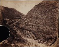
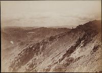
Two versions of a viewbook, each with a different binding, that consist of photographs along the Columbia River, as well as images of Idaho, Oregon, and Washington, created by Isaac Grundy Davidson and compiled by printer George H. Himes, both from Po...
Description:
The complete title of the volume is “Oregon and the Pacific Northwest. Glimpses of pretty spots along the valley of the Columbia River from Northern Montana to the Pacific Ocean. Scenery along the line of the Northern Pacific Railroad, showing the n...
Subject (Geographic):
Northwest, Pacific, Astoria (Or.), Beacon Rock (Wash.), Bradford Island (Or.), Bridal Veil Falls (Or.), Cabinet (Idaho), Cape Disappointment State Park (Wash.), Clark Fork (Idaho : Town), Clark Fork (Mont. and Idaho), Coeur d'Alene Lake (Idaho), Columbia River, Fort Sherman (Idaho), Idaho, Latourell Falls (Or.), Meacham Creek (Or.), Meacham Creek Canyon (Or.), Multnomah Falls (Or.), Oregon, Portland (Or.), Puget Sound (Wash.), Puyallup River (Wash.), Rainier, Mount (Wash.), Riparia (Wash.), Seattle (Wash.), Snake River (Wyo.-Wash.), Spokane Falls (Wash. : Waterfall), Umatilla River (Or.), and Washington (State)
Subject (Name):
Davidson, I. G. 1845-1922. (Isaac Grundy),, Himes, George H., 1844-1940., Rockwell, Cleveland, 1837-1907., Northern Pacific Railway Company, Oregon Furniture Manufacturing Company., and Oregon Railway and Navigation Company
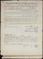
Collection includes receipts, bills, forms, IOUs, a subpoena, deeds, maps, claims, and a draft of a bill belonging to several prominent Oregon men, including several governors. George Abernethy's signature appears on a bill and a receipt dated 1843 an...
Description:
George Abernethy was a prominent Oregon businessman and first provisional governor of Oregon. La Fayette Grover was clerk of the U.S. District Court of Salem, and later governor of Oregon. John P. Gaines was governor of the Oregon Territory, 1850-1853...
Subject (Geographic):
Multnomah County (Or.), Oregon, and Portland (Or.)
Subject (Name):
Abernethy, George, 1807-1877., Gaines, John Pollard, 1795-1857., Grover, La Fayette, 1823-1911., Lownsdale, Daniel H., Smith, Noyes., and Stark, Benjamin, 1820-1898.
Subject (Topic):
Tututni Indians, Population, and Politics and government
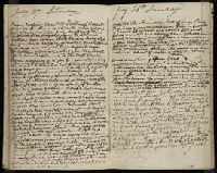
The letters from Jesse Applegate to his brother Lisbon Applegate (1803-1875) discuss family affairs, life in Oregon, land transactions, literature, politics, the Provisional Government, and his exploration of a new route from Fort Hall to the Willamet...
Description:
Jesse Applegate joined the 1843 emigration to Oregon from Missouri, led the 1845 party that opened the southern road or "Applegate Trail" into Oregon, and was a member of the 1845 committee establishing the Provisional Government of Oregon.
Subject (Geographic):
Oregon., Oregon, Umpqua River Valley (Or.), and West (U.S.)
Subject (Name):
Applegate, Jesse, 1811-1888., Applegate, Lisbon, 1803-1875., Farrar, William H., McKinlay, Archibald, 1811-1891., Preston, Jno. B. (John B.), and Allan and McKinlay.
Subject (Topic):
Frontier and pioneer life, Mines and mineral resources, Description and travel, and Politics and government
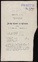
The collection consists of bills, deeds, contracts, receipts, statements of account, correspondence, copies of court actions, Indian War claims, and licenses reflecting the activities of Oregon pioneers. The printed Indian War claims are: John Swindin...
Description:
John T. Apperson was a lieutenant in the Army at Ft. Walla Walla and Ft. Dalles, Oregon in 1863-1864. Augustine Magloire Alexander Blanchet was Bishop of Nesqually, Multnomah County. Amory Holbrook was U. S. Attorney for the Oregon Territory.
Subject (Geographic):
Oregon., Nesqually (Or.), Oregon, and Yamhill County (Or.)
Subject (Name):
Apperson, John T., 1834-1873., Blanchet, Augustine Magloire Alexander, 1797-1887., Chadwick, Stephen Fowler, 1825-1895., Crosby, Nathaniel, Jr., Hammer, Seth R., Holbrook, Amory, 1820-1866., Lownsdale, Daniel H., Redfield, John W., Selwood, J. R. W., Stanton, Hardy C., Swindin, John., and Winter, William, 1836-1917.
Subject (Topic):
Indians of North America, Claims, Wars, Rogue River Indian War, 1855-1856, Tututni Indians, and Politics and government
In 1850 Frush traveled from Missouri to Oregon by way of St. Joseph, Blue River, the North Platte, and Fort Laramie, where he met his brother John and Kit Carson. They continued by South Pass, Bear River, Soda Springs, Fort Hall, Fort Boise, the Dalle...
Description:
Frush, of Newark, Missouri, traveled to Oregon in 1850, organized the Pacific Telegraph Company in 1855, and was buried in Lone Fir Cemetery, Portland, Oregon.
Subject (Geographic):
Oregon., Oregon, and West (U.S.)
Subject (Name):
Frush, John H. and Frush, Wm. H. (William H.)
Subject (Topic):
Frontier and pioneer life, Overland journeys to the Pacific, and Description and travel