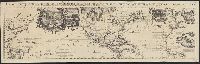
In top margin of sheet 1: Le tout pour l'intelligence des dissertations suivantes., Includes portraits of explorers, illustrations of indigenous peoples, wildlife, flora, historical notes, and ecclesiastical plot ownerships in Havana and Veracruz., and Shows sa
Publisher:
s.n.,
Subject (Geographic):
North America--Maps--Early works to 1800, Pacific Ocean--Maps--Early works to 1800, and South America--Maps--Early works to 1800
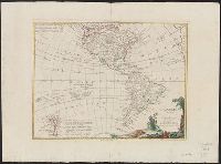
Includes text and ill., Possibly from Zatta's Atlante novissimo [1788]., Relief shown by hachures., Sheet measures 42 x 57 cm. Verso: "14" in ink ms. Franklin Collection., and Shows also the Pacific Ocean to New Zealand.
Publisher:
Presso Antonio Zatta ... ,
Subject (Geographic):
America--Maps--Early works to 1800 and Pacific Ocean--Maps--Early works to 1800
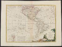
Includes text and ill., Possibly from Zatta's Atlante novissimo [1788]., Relief shown by hachures., Sheet measures 37.5 x 49.5 cm. Verso: Stamped "Yale Horace Brown 1900S". dgvmp2008., and Shows also the Pacific Ocean to New Zealand.
Publisher:
Presso Antonio Zatta ... ,
Subject (Geographic):
America--Maps--Early works to 1800 and Pacific Ocean--Maps--Early works to 1800
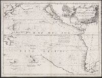
"Dedicato all' Illmo. et Eccmo. Signor. il Signor Cavalier Gvlio Givstinian Sauio Grande"., Map Collection acquisition record: *128., Shows California as an island., Shows the "Viaggio di Giac. le Maire negli Anni 1615, 1616, e 1617"., and Text in Italian with so
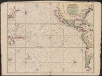
Pascaerte vande Zvyd-Zee tussche California, en Ilhas de Ladrones
Description:
Chart of the Pacific Ocean showing the coastlines of Tasmania, Carpentaria, New Guinea, Japan, California, and Pacific Islands., Mounted on linen. Cross Collection no., and Scale is given in English, French, Dutch, and Spanish miles.
Publisher:
By Pieter Goos, op't Waater inde Vergulde Zeespiegel,
Subject (Geographic):
Pacific Ocean--Maps--Early works to 1800
Subject (Name):
Goos, Pieter, approximately 1616-1675. Zee-atlas ofte water-wereld