Skip to search
Skip to main content
Skip to first result
Search
You Searched For
Subject (Geographic)
Pennsylvania--Maps--Early works to 1800
New Search
Search Results
Published / Created:
1870
Call Number:
774 1870H
Container / Volume:
BRBL_00730
Image Count:
4
Resource Type:
Maps, Atlases & Globes
Found in:
Beinecke Rare Book and Manuscript Library > A map of the province of Pennsilvania ... / by Thomas Holme ...
Published / Created:
1778
Call Number:
774hc T76 1778
Container / Volume:
BRBL_00502
Image Count:
1
Resource Type:
Maps, Atlases & Globes
Found in:
Beinecke Rare Book and Manuscript Library > British Camp at Trudruffrin from the 18th to the 21th of September 1777 with the Attack made by Major General Gray against the Rebels near White Horse tavern on the 20th of September. Drawn by an Officer on the Spot.
Published / Created:
1784
Call Number:
774hc G22 1777
Container / Volume:
BRBL_00502
Image Count:
1
Resource Type:
Maps, Atlases & Globes
Found in:
Beinecke Rare Book and Manuscript Library > Sketch of the surprise of German Town. by the American forces commanded by General Washington. October 4th 1777; by J. Hills,lt.23d Regt. & Asst. Eng.
Creator:
Published / Created:
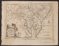
[1757]
Call Number:
777 1758
Container / Volume:
BRBL_00690
Image Count:
1
Resource Type:
Maps, Atlases & Globes
Found in:
Beinecke Rare Book and Manuscript Library > A map of Maryland with the Delaware counties and the southern part of New Jersey &c / [cartographic material] / by T. Kitchin geogr.
Creator:
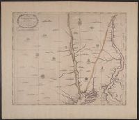
Published / Created:
1792]
Call Number:
774 1792B
Container / Volume:
BRBL_00498
Image Count:
1
Resource Type:
Maps, Atlases & Globes
Found in:
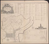
Beinecke Rare Book and Manuscript Library > A map of Pennsylvania & the parts connected therewith, relating to the roads and inland navigation, especially as proposed to be improved the the late proceedings of Assembly / [cartographic material] / (copied from his larger map) by Reading Howell ; J.
Creator:
Published / Created:
1797
Call Number:
774 1797
Container / Volume:
BRBL_00730
Image Count:
1
Resource Type:
Maps, Atlases & Globes
Found in:
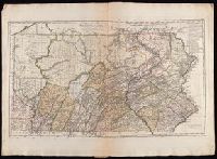
Beinecke Rare Book and Manuscript Library > Pennsylvania / entworfen von D.F. Sotzman[n].
Creator:
Published / Created:
1759
Call Number:
774 1759
Container / Volume:
BRBL_00497
Image Count:
3
Resource Type:
Maps, Atlases & Globes
Found in:
Beinecke Rare Book and Manuscript Library > To the honourable Thomas Penn and Richard Penn...this map of the improved part of the province of Pennsylvania is humbly dedicated / by Nicholas Scull ; engraved by Ja. Turner.
Published / Created:
[1681]
Call Number:
774 1681
Container / Volume:
BRBL_00497
Image Count:
3
Resource Type:
Maps, Atlases & Globes
Found in:
Beinecke Rare Book and Manuscript Library > A Map of Some of the South and east bounds of Pennsylvania in America ... Sold by John Thornton ... and by John Seller ... London.
Creator:
Published / Created:
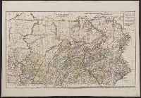
1797
Call Number:
1977 Folio 177
Image Count:
2
Resource Type:
Maps, Atlases & Globes
Found in:
Beinecke Rare Book and Manuscript Library > Pennsylvania / entworfen von D.F. Sotzman[n].
Branch:v1.60.98 ,Deployed:2024-04-24T10:14:36-04:00